படிமம்:Europe before Operation Barbarossa, 1941 (in German).png

இந்த முன்னோட்டத்தின் அளவு: 575 × 599 படப்புள்ளிகள் . மற்ற பிரிதிறன்கள்: 230 × 240 படப்புள்ளிகள் | 461 × 480 படப்புள்ளிகள் | 958 × 998 படப்புள்ளிகள் .
மூலக்கோப்பு (958 × 998 படவணுக்கள், கோப்பின் அளவு: 142 KB, MIME வகை: image/png)
| இது விக்கிமீடியா பொதுக்கோப்பகத்தில் இருக்கும் ஒரு கோப்பாகும். இக்கோப்பைக் குறித்து அங்கே காணப்படும் படிம விளக்கப் பக்கத்தை இங்கே கீழே காணலாம்.
|
சுருக்கம்
| விளக்கம் |
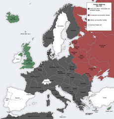
English: Map showing the Nazi, Finnish and Soviet-controlled borders of Europe by the end of May/beginning of June 1941, by the conclusion of the Nazi invasion of the Balkans and before Operation Barbarossa.
This PNG image, with captions in German, is derived from a frame from the GIF animation File:Second world war europe animation large de.gif at Wikimedia Commons. |
| நாள் | 7 ஏப்பிரல் 2010 (original upload date) |
| மூலம் | Transferred from en.wikipedia to Commons. |
| ஆசிரியர் |
The original uploader was MaGioZal at ஆங்கிலம் விக்கிப்பீடியா.. Later version(s) were uploaded by DIREKTOR at en.wikipedia. |
| ஒத்தக்கோப்பு |
|
.png)
.png)

|
This military map image could be re-created using vector graphics as an SVG file. This has several advantages; see Commons:Media for cleanup for more information. If an SVG form of this image is available, please upload it and afterwards replace this template with
{{vector version available|new image name}}.
It is recommended to name the SVG file “Europe before Operation Barbarossa, 1941 (in German).svg”—then the template Vector version available (or Vva) does not need the new image name parameter. |
அனுமதி

|
GNU Free Documentation License விதிமுறைகளின் கீழ் இந்த ஆவணத்தை நகலெடுக்க, விநியோகிக்க மற்றும்/அல்லது மாற்றுவதற்கு அனுமதி வழங்கப்பட்டுள்ளது, Free Software Foundation;ஆல் வெளியிடப்பட்ட பதிப்பு 1.2 அல்லது அதற்குப் பிந்தைய பதிப்பு, மாற்றமில்லாத பிரிவுகள், முன் அட்டை உரைகள் மற்றும் பின் அட்டை உரைகள் இல்லாமல் வெளியிடப்பட்டது. GNU Free Documentation License என்ற தலைப்பில் உரிமத்தின் நகல் சேர்க்கப்பட்டுள்ளது. |
| இந்த கோப்பு Creative Commons Attribution-Share Alike 3.0 Unported உரிமத்தின் கீழ் உள்ளது. | ||
| ||
| This licensing tag was added to this file as part of the GFDL licensing update. |
Original upload log
The original description page was here. All following user names refer to en.wikipedia.
- 2012-05-22 17:09 DIREKTOR 958×998× (200029 bytes) Colours
- 2010-04-07 01:43 MaGioZal 960×1000× (149500 bytes) Map showing the Nazi (darker blue) and Soviet-controlled (green) borders of Europe by the end of May/beginning of June [[1941]], after the [[Balkans Campaign|Nazi invasion of the Balkans]] and before [[Operation Barbarossa]]. This [[PNG image]], with cap
கோப்பின் வரலாறு
குறித்த நேரத்தில் இருந்த படிமத்தைப் பார்க்க அந்நேரத்தின் மீது சொடுக்கவும்.
| நாள்/நேரம் | நகம் அளவு சிறுபடம் | அளவுகள் | பயனர் | கருத்து | |
|---|---|---|---|---|---|
| தற்போதைய | 18:13, 7 செப்டெம்பர் 2012 | | 958 × 998 (142 KB) | Illythr | Removed the "changes in the last frame" coloring, as there's only one frame here and the legend was misleading. |
| 02:09, 16 ஆகத்து 2012 |  | 958 × 998 (195 KB) | OgreBot | (BOT): Reverting to most recent version before archival | |
| 02:09, 16 ஆகத்து 2012 |  | 960 × 1,000 (146 KB) | OgreBot | (BOT): Uploading old version of file from en.wikipedia; originally uploaded on 2010-04-07 01:43:08 by MaGioZal | |
| 20:04, 22 சூன் 2012 |  | 958 × 998 (195 KB) | Friedlibend und tapfer | {{Information |Description={{en|Map showing the Nazi and Soviet-controlled borders of Europe by the end of May/beginning of June 1941, by the conclusion of the Nazi invasion of the Balkans and before [[:en:Operatio... |
கோப்பு பயன்பாடு
பின்வரும் பக்க இணைப்புகள் இப் படிமத்துக்கு இணைக்கபட்டுள்ளது(ளன):
கோப்பின் முழுமையான பயன்பாடு
கீழ்கண்ட மற்ற விக்கிகள் இந்த கோப்பை பயன்படுத்துகின்றன:
- af.wikipedia.org-திட்டத்தில் இதன் பயன்பாடு
- ar.wikipedia.org-திட்டத்தில் இதன் பயன்பாடு
- ast.wikipedia.org-திட்டத்தில் இதன் பயன்பாடு
- azb.wikipedia.org-திட்டத்தில் இதன் பயன்பாடு
- az.wikipedia.org-திட்டத்தில் இதன் பயன்பாடு
- bg.wikipedia.org-திட்டத்தில் இதன் பயன்பாடு
- bn.wikipedia.org-திட்டத்தில் இதன் பயன்பாடு
- br.wikipedia.org-திட்டத்தில் இதன் பயன்பாடு
- ca.wikipedia.org-திட்டத்தில் இதன் பயன்பாடு
- cs.wikipedia.org-திட்டத்தில் இதன் பயன்பாடு
- en.wikipedia.org-திட்டத்தில் இதன் பயன்பாடு
- Continuation War
- Molotov–Ribbentrop Pact
- Operation Barbarossa
- Eastern Front (World War II)
- Balkans campaign (World War II)
- Interim Peace
- User:Dead Mary/sandbox6
- User:Dead Mary/sandbox7
- Presidency of Franklin D. Roosevelt, third and fourth terms
- Foreign policy of the Franklin D. Roosevelt administration
- User:Falcaorib/Europe
- User:Falcaorib/Germany and Prussia
- eo.wikipedia.org-திட்டத்தில் இதன் பயன்பாடு
- es.wikipedia.org-திட்டத்தில் இதன் பயன்பாடு
- fi.wikipedia.org-திட்டத்தில் இதன் பயன்பாடு
- hy.wikipedia.org-திட்டத்தில் இதன் பயன்பாடு
- lt.wikipedia.org-திட்டத்தில் இதன் பயன்பாடு
- lv.wikipedia.org-திட்டத்தில் இதன் பயன்பாடு
- nl.wikipedia.org-திட்டத்தில் இதன் பயன்பாடு
- pnb.wikipedia.org-திட்டத்தில் இதன் பயன்பாடு
- pt.wikipedia.org-திட்டத்தில் இதன் பயன்பாடு
- ru.wikipedia.org-திட்டத்தில் இதன் பயன்பாடு
- th.wikipedia.org-திட்டத்தில் இதன் பயன்பாடு
- ur.wikipedia.org-திட்டத்தில் இதன் பயன்பாடு
- zh.wikipedia.org-திட்டத்தில் இதன் பயன்பாடு
.png)