படிமம்:Sri Lanka geopolitics, 1520s.png
இந்த முன்னோட்டத்தின் அளவு: 444 × 599 படப்புள்ளிகள் . மற்ற பிரிதிறன்கள்: 178 × 240 படப்புள்ளிகள் | 356 × 480 படப்புள்ளிகள் | 700 × 944 படப்புள்ளிகள் .
மூலக்கோப்பு (700 × 944 படவணுக்கள், கோப்பின் அளவு: 703 KB, MIME வகை: image/png)
| இது விக்கிமீடியா பொதுக்கோப்பகத்தில் இருக்கும் ஒரு கோப்பாகும். இக்கோப்பைக் குறித்து அங்கே காணப்படும் படிம விளக்கப் பக்கத்தை இங்கே கீழே காணலாம்.
|
சுருக்கம்
| விளக்கம் |
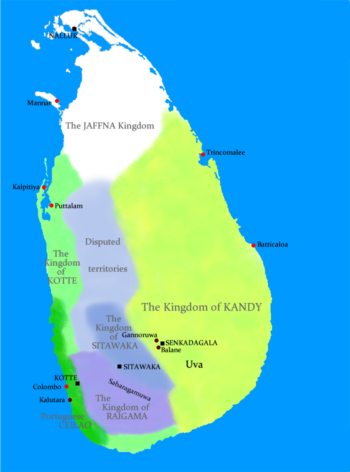
Geopolitical situation in Sri Lanka in the 1520s This map has serious errors - Colombo is marked wrong and according to the map, Anuradhapura is shown as part of Jaffna Kingdom. No References are given either. |
| நாள் | 21 ஆகத்து 2009 (original upload date) |
| மூலம் | No machine-readable source provided. Own work assumed (based on copyright claims). |
| ஆசிரியர் | No machine-readable author provided. Docsubster assumed (based on copyright claims). |
அனுமதி
| I, the copyright holder of this work, release this work into the public domain. This applies worldwide. சில நாடுகளில் இது சாத்தியமில்லாது போகலாம். அவ்வாறாயின் : I grant anyone the right to use this work for any purpose, without any conditions, unless such conditions are required by law. |
கோப்பின் வரலாறு
குறித்த நேரத்தில் இருந்த படிமத்தைப் பார்க்க அந்நேரத்தின் மீது சொடுக்கவும்.
| நாள்/நேரம் | நகம் அளவு சிறுபடம் | அளவுகள் | பயனர் | கருத்து | |
|---|---|---|---|---|---|
| தற்போதைய | 13:54, 21 ஆகத்து 2009 | | 700 × 944 (703 KB) | Docsubster | Geopolitical situation in Sri Lanka in the 1520s |
கோப்பு பயன்பாடு
பின்வரும் பக்க இணைப்புகள் இப் படிமத்துக்கு இணைக்கபட்டுள்ளது(ளன):
கோப்பின் முழுமையான பயன்பாடு
கீழ்கண்ட மற்ற விக்கிகள் இந்த கோப்பை பயன்படுத்துகின்றன:
- ar.wikipedia.org-திட்டத்தில் இதன் பயன்பாடு
- de.wikipedia.org-திட்டத்தில் இதன் பயன்பாடு
- en.wikipedia.org-திட்டத்தில் இதன் பயன்பாடு
- id.wikipedia.org-திட்டத்தில் இதன் பயன்பாடு
- io.wikipedia.org-திட்டத்தில் இதன் பயன்பாடு
- it.wikipedia.org-திட்டத்தில் இதன் பயன்பாடு
- ne.wikipedia.org-திட்டத்தில் இதன் பயன்பாடு
- ru.wikipedia.org-திட்டத்தில் இதன் பயன்பாடு
- uk.wikipedia.org-திட்டத்தில் இதன் பயன்பாடு