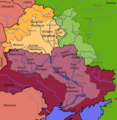
படிமம்:Dnipro Basin River Town International.png

இந்த முன்னோட்டத்தின் அளவு: 584 × 600 படப்புள்ளிகள் . மற்ற பிரிதிறன்கள்: 234 × 240 படப்புள்ளிகள் | 467 × 480 படப்புள்ளிகள் | 748 × 768 படப்புள்ளிகள் | 997 × 1,024 படப்புள்ளிகள் | 1,316 × 1,352 படப்புள்ளிகள் .
மூலக்கோப்பு (1,316 × 1,352 படவணுக்கள், கோப்பின் அளவு: 1.07 MB, MIME வகை: image/png)
கோப்பின் வரலாறு
குறித்த நேரத்தில் இருந்த படிமத்தைப் பார்க்க அந்நேரத்தின் மீது சொடுக்கவும்.
| நாள்/நேரம் | நகம் அளவு சிறுபடம் | அளவுகள் | பயனர் | கருத்து | |
|---|---|---|---|---|---|
| தற்போதைய | 15:54, 30 சூலை 2023 |  | 1,316 × 1,352 (1.07 MB) | DinoSoupCanada | Kakhovka Reservoir mostly dried up; some small small remainders on the coastline |
| 13:31, 9 சூன் 2023 |  | 750 × 772 (334 KB) | DinoSoupCanada | River expansion after destruction of Kakhovka Dam | |
| 08:37, 7 மார்ச்சு 2007 |  | 750 × 772 (227 KB) | Dcoetzee | Removed watermark, pngcrushed | |
| 13:13, 1 மார்ச்சு 2007 |  | 750 × 772 (278 KB) | Numerius Negidius | Basin of the Dnipro river, based on Image:Dnepr Basin River Town blank.png by User:КаіСорен == Licensing == {{self2|GFDL|cc-by-2.5}} {{watermark}} | |
| 12:17, 1 மார்ச்சு 2007 |  | 750 × 772 (278 KB) | Numerius Negidius | Basin of the Dnipro river, based on Image:Dnepr Basin River Town blank.png by User:КаіСорен == Licensing == {{self2|GFDL|cc-by-2.5}} {{watermark}} | |
| 12:11, 1 மார்ச்சு 2007 |  | 750 × 772 (278 KB) | Numerius Negidius | Basin of the Dnipro river, based on Image:Dnepr Basin River Town blank.png by User:КаіСорен == Licensing == {{self2|GFDL|cc-by-2.5}} {{watermark}} |
கோப்பு பயன்பாடு
பின்வரும் பக்க இணைப்புகள் இப் படிமத்துக்கு இணைக்கபட்டுள்ளது(ளன):
கோப்பின் முழுமையான பயன்பாடு
கீழ்கண்ட மற்ற விக்கிகள் இந்த கோப்பை பயன்படுத்துகின்றன:
- af.wikipedia.org-திட்டத்தில் இதன் பயன்பாடு
- ar.wikipedia.org-திட்டத்தில் இதன் பயன்பாடு
- arz.wikipedia.org-திட்டத்தில் இதன் பயன்பாடு
- azb.wikipedia.org-திட்டத்தில் இதன் பயன்பாடு
- be.wikipedia.org-திட்டத்தில் இதன் பயன்பாடு
- bh.wikipedia.org-திட்டத்தில் இதன் பயன்பாடு
- bn.wikipedia.org-திட்டத்தில் இதன் பயன்பாடு
- ca.wikipedia.org-திட்டத்தில் இதன் பயன்பாடு
- da.wikipedia.org-திட்டத்தில் இதன் பயன்பாடு
- de.wikipedia.org-திட்டத்தில் இதன் பயன்பாடு
- el.wiktionary.org-திட்டத்தில் இதன் பயன்பாடு
- en.wikipedia.org-திட்டத்தில் இதன் பயன்பாடு
- Dnieper
- Berezina
- Pripyat (river)
- Desna (river)
- Irpin (river)
- Ros (river)
- Trubizh
- Konka (river, Zaporizhzhia Oblast)
- Stuhna
- Dnieper Hydroelectric Station
- Vorskla
- Dnieper Balts
- Samara (Dnieper)
- Kremenchuk Reservoir
- Kyiv Reservoir
- Kakhovka Reservoir
- Dnieper reservoir cascade
- Kamianske Reservoir
- Kaniv Reservoir
- Dnieper Reservoir
- Template:Dnieper River
- Sula (Dnieper)
- Teteriv
- Psel (river)
- Inhulets
- Tiasmyn
- Drut (river)
- Bazavluk
- Territorial evolution of the Ottoman Empire
- Zolotonoshka (river)
- Kaniv Hydroelectric Power Plant
- Sozh
- Kyiv Hydroelectric Power Plant
- Kyiv Pumped Storage Power Plant
- Middle Dnieper Hydroelectric Station
- Kakhovka Dam
சிறப்பு பக்கம்-மொத்த பயன்பாடு - இதன் மூலம் இந்த கோப்பின் மொத்த பயன்பாட்டை அறிய முடியும்


