படிமம்:EU27-2008 as a single entity in the world.svg

Size of this PNG preview of this SVG file: 800 × 443 படப்புள்ளிகள். மற்ற பிரிதிறன்கள்: 320 × 177 படப்புள்ளிகள் | 640 × 354 படப்புள்ளிகள் | 1,024 × 567 படப்புள்ளிகள் | 1,280 × 709 படப்புள்ளிகள் | 2,560 × 1,417 படப்புள்ளிகள் | 999 × 553 படப்புள்ளிகள் .
மூலக்கோப்பு (SVG கோப்பு, பெயரளவில் 999 × 553 பிக்சல்கள், கோப்பு அளவு: 561 KB)
| இது விக்கிமீடியா பொதுக்கோப்பகத்தில் இருக்கும் ஒரு கோப்பாகும். இக்கோப்பைக் குறித்து அங்கே காணப்படும் படிம விளக்கப் பக்கத்தை இங்கே கீழே காணலாம்.
|
சுருக்கம்
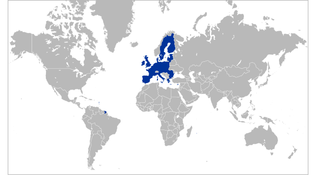
| விளக்கம் | Locator map for territory claimed by the European Union (EU 27) |
| நாள் | |
| மூலம் | Own work based on: Location European Union.svg by Ssolbergj |
| ஆசிரியர் | Kolja21 |
| ஒத்தக்கோப்பு |
|
| SVG genesis |


அனுமதி
இந்த ஆக்கத்தின் காப்புரிமையாளரான நான் இதனைப் பின்வரும் உரிமத்தின் கீழ் வெளியிடுகின்றேன்:
This file is licensed under the Creative Commons Attribution 3.0 Unported license.
- நீங்கள் சுதந்திரமாக:
- பகிர்ந்து கொள்ள – வேலையை நகலெடுக்க, விநியோகிக்க மற்றும் அனுப்ப
- மீண்டும் கலக்க – வேலைக்கு பழகிக்கொள்ள.
- கீழ்க்காணும் விதிகளுக்கு ஏற்ப,
- பண்புக்கூறுகள் – நீங்கள் பொருத்தமான உரிமையை வழங்க வேண்டும், உரிமத்திற்கான இணைப்பை வழங்க வேண்டும் மற்றும் மாற்றங்கள் செய்யப்பட்டிருந்தால் குறிப்பிட வேண்டும். நீங்கள் ஏற்புடைய எந்த முறையிலும் அவ்வாறு செய்யலாம், ஆனால் எந்த வகையிலும் உரிமதாரர் உங்களை அல்லது உங்கள் பயன்பாட்டிற்கு ஒப்புதல் அளிக்கும் படி பரிந்துரைக்க கூடாது.
Original upload log
This image is a derivative work of the following images:
- Location European Union.svg licensed with GFDL-en
- 2008-10-18T11:51:01Z Ssolbergj 999x553 (586765 Bytes) What does that mean?
- 2008-10-18T09:07:46Z SeNeKa 940x415 (1552215 Bytes) More correctly
- 2008-10-03T21:24:30Z Ssolbergj 999x553 (586765 Bytes) UNLESS YOU READ THE EDIT HISTORY AND WRITE EDIT SUMMARIES, REVERTING = VANDALISM
- 2008-10-02T11:39:09Z SeNeKa 940x415 (1552215 Bytes) Reverted to version as of 04:36, 23 September 2008
- 2008-09-25T10:50:14Z Ssolbergj 999x553 (586765 Bytes) Revert. Please read the edit history.
- 2008-09-23T04:36:51Z Bože pravde 940x415 (1552215 Bytes) Reverted to version as of 12:16, 17 September 2008
- 2008-09-19T21:16:27Z Ssolbergj 999x553 (586765 Bytes) Please read the edit history.
- 2008-09-17T12:16:21Z SeNeKa 940x415 (1552215 Bytes) remake
- 2008-05-21T14:38:23Z Ssolbergj 999x553 (586765 Bytes) {{Information |Description= |Source= |Date= |Author= |Permission= |other_versions= }}
- 2008-05-21T14:36:24Z Ssolbergj 999x628 (586765 Bytes) {{Information |Description= |Source= |Date= |Author= |Permission= |other_versions= }}
- 2008-05-21T14:31:41Z Ssolbergj 999x634 (586754 Bytes) {{Information |Description= |Source= |Date= |Author= |Permission= |other_versions= }}
- 2008-05-19T12:55:50Z Ssolbergj 250x170 (573479 Bytes) Reverted to version as of 17:04, 26 February 2008
- 2008-05-19T12:54:16Z Ssolbergj 1052x695 (586656 Bytes) {{Information |Description= |Source= |Date= |Author= |Permission= |other_versions= }}
- 2008-02-26T17:04:41Z Ssolbergj 250x170 (573479 Bytes) I wrote an edit summary, and so should you. The [[:en:Robinson projection|Robinson projection]] does squeeze Europe. The [[:en:Mercator projection|Mercator projection]] is more appropriate for the European Union.
- 2008-02-24T17:15:15Z Barryob 940x477 (2399134 Bytes) Reverted to version as of 23:57, 12 June 2007
- 2008-02-18T01:47:55Z Ssolbergj 250x170 (573479 Bytes) {{Information |Description= |Source= |Date= |Author= |Permission= |other_versions= }}
- 2008-02-18T01:32:08Z Ssolbergj 1021x674 (574168 Bytes) {{Information |Description= |Source= |Date= |Author= |Permission= |other_versions= }}
- 2008-02-18T01:12:36Z Ssolbergj 1021x674 (574196 Bytes) A map projection that doesn't distort the northern hemisphere so much.
- 2007-06-12T23:57:21Z Guilherme Paula 940x477 (2399134 Bytes) == Summary == {{Information |Description=Locator map for the [[en:European Union|European Union]] in 2007 |Source=English Wikipedia |Date=2 June 2007 |Author=[[en:User:Ssolbergj]] |Permission=}} == Licensing == {{GF
Uploaded with derivativeFX
கோப்பின் வரலாறு
குறித்த நேரத்தில் இருந்த படிமத்தைப் பார்க்க அந்நேரத்தின் மீது சொடுக்கவும்.
| நாள்/நேரம் | நகம் அளவு சிறுபடம் | அளவுகள் | பயனர் | கருத்து | |
|---|---|---|---|---|---|
| தற்போதைய | 03:32, 7 பெப்பிரவரி 2009 | | 999 × 553 (561 KB) | Kolja21 | == Summary == {{Information |Description=Locator map for the European Union (EU 27) |Source=*File:Location_European_Union.svg |Date=2009-02-07 03:30 (UTC) |Author=*File:Location_European_Union.svg: [[:en:user:Ssolbergj|S |
கோப்பு பயன்பாடு
இப் படிமத்துக்கு இணைக்கப்பட்டுள்ள பக்கங்கள் எதுவும் இல்லை.