படிமம்:English administrative divisions by type 2009.svg

Size of this PNG preview of this SVG file: 494 × 600 படப்புள்ளிகள். மற்ற பிரிதிறன்கள்: 198 × 240 படப்புள்ளிகள் | 395 × 480 படப்புள்ளிகள் | 633 × 768 படப்புள்ளிகள் | 843 × 1,024 படப்புள்ளிகள் | 1,687 × 2,048 படப்புள்ளிகள் | 1,108 × 1,345 படப்புள்ளிகள் .
மூலக்கோப்பு (SVG கோப்பு, பெயரளவில் 1,108 × 1,345 பிக்சல்கள், கோப்பு அளவு: 504 KB)
| இது விக்கிமீடியா பொதுக்கோப்பகத்தில் இருக்கும் ஒரு கோப்பாகும். இக்கோப்பைக் குறித்து அங்கே காணப்படும் படிம விளக்கப் பக்கத்தை இங்கே கீழே காணலாம்.
|
சுருக்கம்
| விளக்கம் |
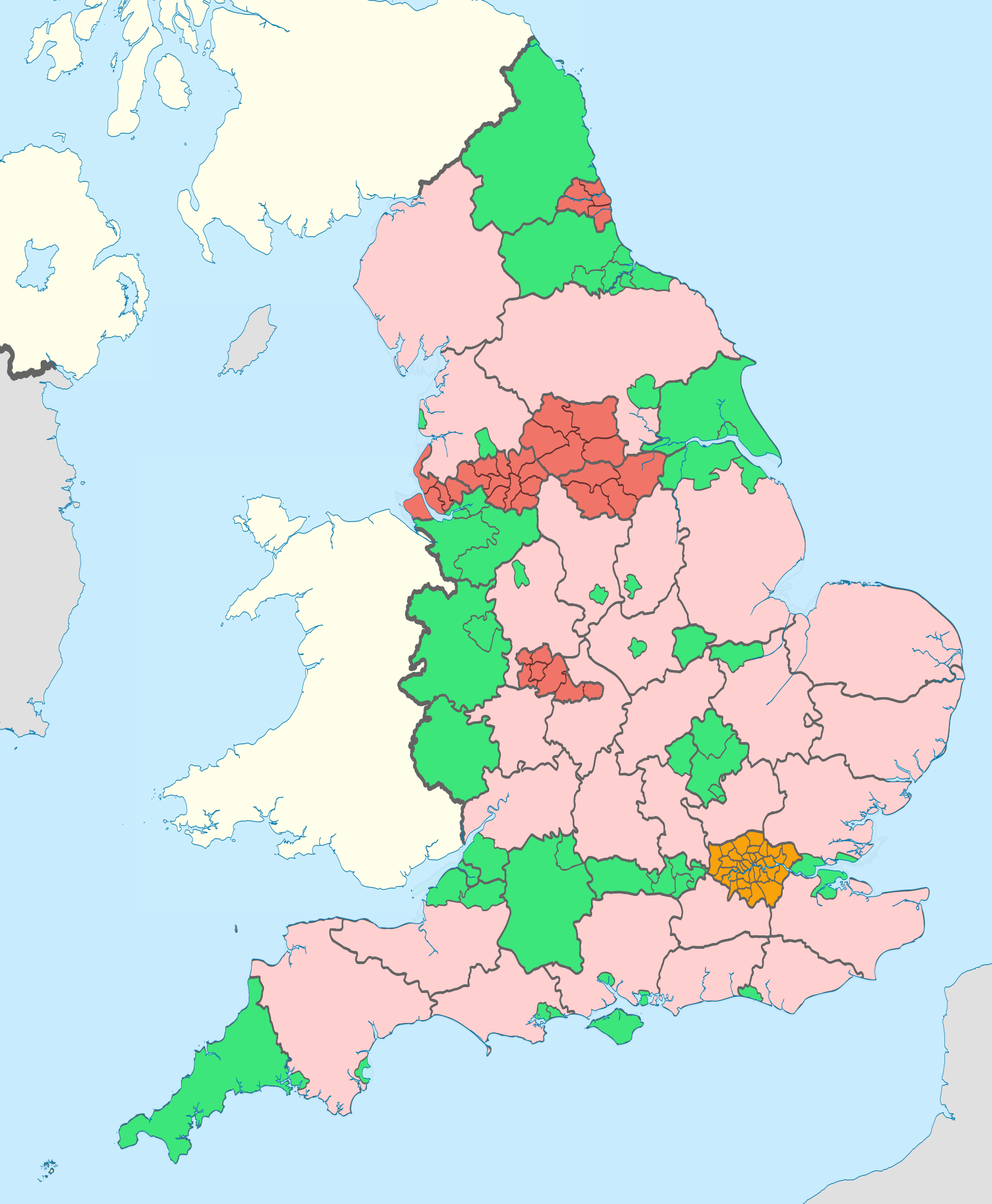
English: Map showing the all top-tier administrative subdivisions of England (shire counties, metropolitan boroughs, London boroughs and unitary authorities) from 2009 to 31 March 2019.
The thicker black lines are the ceremonial county boundaries. Equirectangular map projection on WGS 84 datum, with N/S stretched 170% Geographic limits:
|
| நாள் | (UTC) |
| மூலம் |
This file was derived from: English administrative divisions 2010.svg:  |
| ஆசிரியர் |
|
| ஒத்தக்கோப்பு |
|
| இது ஒரு திருத்தப்பட்ட படிமமாகும், அதாவது இதன் மூல வடிவத்திலிருந்து கணினி மூலம் இதில் மாற்றங்கள் செய்யப்பட்டுள்ளது. திருத்தங்கள்: recoloured with ceremonial county boundaries thickened. மூலக்கோப்பை இங்கு காணலாம்: English administrative divisions 2010.svg. திருத்தங்களைச் செய்தவர் Dr Greg.
|
அனுமதி
இந்த ஆக்கத்தின் காப்புரிமையாளரான நான் இதனைப் பின்வரும் உரிமத்தின் கீழ் வெளியிடுகின்றேன்:
இந்த கோப்பு Creative Commons Attribution-Share Alike 3.0 Unported உரிமத்தின் கீழ் உள்ளது.
பண்புக்கூறுகள்: Nilfanion and Dr Greg
- நீங்கள் சுதந்திரமாக:
- பகிர்ந்து கொள்ள – வேலையை நகலெடுக்க, விநியோகிக்க மற்றும் அனுப்ப
- மீண்டும் கலக்க – வேலைக்கு பழகிக்கொள்ள.
- கீழ்க்காணும் விதிகளுக்கு ஏற்ப,
- பண்புக்கூறுகள் – நீங்கள் பொருத்தமான உரிமையை வழங்க வேண்டும், உரிமத்திற்கான இணைப்பை வழங்க வேண்டும் மற்றும் மாற்றங்கள் செய்யப்பட்டிருந்தால் குறிப்பிட வேண்டும். நீங்கள் ஏற்புடைய எந்த முறையிலும் அவ்வாறு செய்யலாம், ஆனால் எந்த வகையிலும் உரிமதாரர் உங்களை அல்லது உங்கள் பயன்பாட்டிற்கு ஒப்புதல் அளிக்கும் படி பரிந்துரைக்க கூடாது.
- அதே மாதிரி பகிர் – நீங்கள் ரீமிக்ஸ் செய்தாலோ, உருமாற்றம் செய்தாலோ அல்லது பொருளை உருவாக்கினாலோ, உங்கள் பங்களிப்புகளை அல்லது இணக்கமான உரிமம் கீழ் அசலாக விநியோகிக்க வேண்டும்.

|
GNU Free Documentation License விதிமுறைகளின் கீழ் இந்த ஆவணத்தை நகலெடுக்க, விநியோகிக்க மற்றும்/அல்லது மாற்றுவதற்கு அனுமதி வழங்கப்பட்டுள்ளது, Free Software Foundation;ஆல் வெளியிடப்பட்ட பதிப்பு 1.2 அல்லது அதற்குப் பிந்தைய பதிப்பு, மாற்றமில்லாத பிரிவுகள், முன் அட்டை உரைகள் மற்றும் பின் அட்டை உரைகள் இல்லாமல் வெளியிடப்பட்டது. GNU Free Documentation License என்ற தலைப்பில் உரிமத்தின் நகல் சேர்க்கப்பட்டுள்ளது. |
நீர் உமக்கு விருப்பமான உரிமத்தை தேர்ந்தெடுக்கலாம்.
Original upload log
This image is a derivative work of the following images:
- File:English_administrative_divisions_2010.svg licensed with Cc-by-sa-3.0, GFDL
- 2010-11-23T22:02:28Z Nilfanion 1108x1345 (374390 Bytes) England only
- 2010-11-23T22:00:33Z Nilfanion 1108x1345 (410564 Bytes) {{Information |Description=Map showing the all top-tier administrative subdivisions of England (shire counties, metropolitan counties, London boroughs and Unitary Authorities) in 2010 Equirectangular map projection on WGS 84
Uploaded with derivativeFX
கோப்பின் வரலாறு
குறித்த நேரத்தில் இருந்த படிமத்தைப் பார்க்க அந்நேரத்தின் மீது சொடுக்கவும்.
| நாள்/நேரம் | நகம் அளவு சிறுபடம் | அளவுகள் | பயனர் | கருத்து | |
|---|---|---|---|---|---|
| தற்போதைய | 12:12, 6 மே 2012 | | 1,108 × 1,345 (504 KB) | Dr Greg | paler boundary lines |
| 20:13, 24 மார்ச்சு 2012 |  | 1,108 × 1,345 (504 KB) | Dr Greg | bugfix: Kirklees borough accidentally blurred | |
| 02:14, 21 மார்ச்சு 2012 |  | 1,108 × 1,345 (504 KB) | Dr Greg | adjustments to colour scheme for better contrast | |
| 22:05, 20 மார்ச்சு 2012 |  | 1,108 × 1,345 (504 KB) | Dr Greg | == {{int:filedesc}} == {{Information |Description={{en|Map showing the all top-tier administrative subdivisions of England (shire counties, metropolitan counties, London boroughs and Unitary Authorities) from 2009 (still valid in 2012). *{{color||{{0|... |
கோப்பு பயன்பாடு
பின்வரும் பக்க இணைப்புகள் இப் படிமத்துக்கு இணைக்கபட்டுள்ளது(ளன):
கோப்பின் முழுமையான பயன்பாடு
கீழ்கண்ட மற்ற விக்கிகள் இந்த கோப்பை பயன்படுத்துகின்றன:
- es.wikipedia.org-திட்டத்தில் இதன் பயன்பாடு
- fr.wikipedia.org-திட்டத்தில் இதன் பயன்பாடு
- pt.wikipedia.org-திட்டத்தில் இதன் பயன்பாடு
- simple.wikipedia.org-திட்டத்தில் இதன் பயன்பாடு