படிமம்:Former Yugoslavia 2008.PNG

இந்த முன்னோட்டத்தின் அளவு: 800 × 527 படப்புள்ளிகள் . மற்ற பிரிதிறன்கள்: 320 × 211 படப்புள்ளிகள் | 640 × 421 படப்புள்ளிகள் | 1,024 × 674 படப்புள்ளிகள் | 1,280 × 842 படப்புள்ளிகள் | 1,887 × 1,242 படப்புள்ளிகள் .
மூலக்கோப்பு (1,887 × 1,242 படவணுக்கள், கோப்பின் அளவு: 114 KB, MIME வகை: image/png)
| இது விக்கிமீடியா பொதுக்கோப்பகத்தில் இருக்கும் ஒரு கோப்பாகும். இக்கோப்பைக் குறித்து அங்கே காணப்படும் படிம விளக்கப் பக்கத்தை இங்கே கீழே காணலாம்.
|

|
This map image could be re-created using vector graphics as an SVG file. This has several advantages; see Commons:Media for cleanup for more information. If an SVG form of this image is available, please upload it and afterwards replace this template with
{{vector version available|new image name}}.
It is recommended to name the SVG file “Former Yugoslavia 2008.svg”—then the template Vector version available (or Vva) does not need the new image name parameter. |
சுருக்கம்
| விளக்கம் |
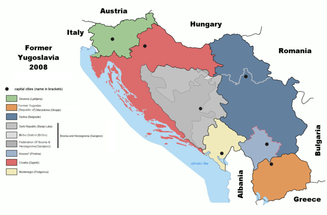
English: Map of former Yugoslavia including Kosovo independence.
Deutsch: Karte des früheren Jugoslawiens einschließlich der Unabhängigkeit des Kosovo. |
| நாள் | |
| மூலம் | derived from File:Former Yugoslavia 2006.png by Dudemanfellabra at en.wikipedia |
| ஆசிரியர் | Ijanderson977 |
| அனுமதி (இக்கோப்பை மீண்டும் பயன்படுத்துதல்) |
Released under the GNU Free Documentation License. |
| ஒத்தக்கோப்பு |
|


Transferred from en:wikipedia to Commons by User:Tieum512 using CommonsHelper.
More versions on en.wikipedia see Original upload log below.
அனுமதி

|
GNU Free Documentation License விதிமுறைகளின் கீழ் இந்த ஆவணத்தை நகலெடுக்க, விநியோகிக்க மற்றும்/அல்லது மாற்றுவதற்கு அனுமதி வழங்கப்பட்டுள்ளது, Free Software Foundation;ஆல் வெளியிடப்பட்ட பதிப்பு 1.2 அல்லது அதற்குப் பிந்தைய பதிப்பு, மாற்றமில்லாத பிரிவுகள், முன் அட்டை உரைகள் மற்றும் பின் அட்டை உரைகள் இல்லாமல் வெளியிடப்பட்டது. GNU Free Documentation License என்ற தலைப்பில் உரிமத்தின் நகல் சேர்க்கப்பட்டுள்ளது. |
| இந்த கோப்பு Creative Commons Attribution-Share Alike 3.0 Unported உரிமத்தின் கீழ் உள்ளது. | ||
| ||
| This licensing tag was added to this file as part of the GFDL licensing update. |
Original upload log
The original description page was here. All following user names refer to en.wikipedia.
- 2009-02-19 05:22 Српска Крајина 1887×1192× (131504 bytes)
- 2008-07-06 20:01 Ijanderson977 1887×1192× (130802 bytes) Corrected spelling from Albanian to English.
- 2008-07-04 00:35 Hoshie 1887×1192× (122315 bytes) Give Kosovo own color due to the change in status.
- 2008-03-18 23:43 Dudemanfellabra 1887×1192× (83000 bytes) Map of former Yugoslavia edited to include Kosovo independence. March 2008 Author: Floyd Maseda (Dudemanfellabra). Original image: [http://en.wikipedia.org/wiki/Image:Former_Yugoslavia_2006.png] June 2006 Author: Paweł Goleniowski (swPawel)
கோப்பின் வரலாறு
குறித்த நேரத்தில் இருந்த படிமத்தைப் பார்க்க அந்நேரத்தின் மீது சொடுக்கவும்.
| நாள்/நேரம் | நகம் அளவு சிறுபடம் | அளவுகள் | பயனர் | கருத்து | |
|---|---|---|---|---|---|
| தற்போதைய | 19:12, 26 அக்டோபர் 2022 | | 1,887 × 1,242 (114 KB) | Ghostantinos | fix |
| 21:06, 26 ஆகத்து 2021 |  | 1,887 × 1,242 (105 KB) | Santasa99 | more npov | |
| 13:53, 27 சூலை 2019 |  | 1,887 × 1,242 (95 KB) | Drax90 | New updated version | |
| 19:05, 22 பெப்பிரவரி 2019 |  | 1,887 × 1,192 (136 KB) | Koreanovsky | Reverted to version as of 10:29, 21 February 2019 (UTC) | |
| 12:06, 21 பெப்பிரவரி 2019 |  | 1,887 × 1,242 (95 KB) | Drax90 | New color scheme | |
| 10:29, 21 பெப்பிரவரி 2019 |  | 1,887 × 1,192 (136 KB) | UglyGoat | Reverted to version as of 17:08, 4 February 2019 (UTC) | |
| 17:44, 12 பெப்பிரவரி 2019 |  | 1,887 × 1,242 (95 KB) | Drax90 | Fixed version of the map | |
| 17:08, 4 பெப்பிரவரி 2019 |  | 1,887 × 1,192 (136 KB) | Koreanovsky | There is no official border between Herzeg-Bosnia and FBiH; Reverted to version as of 23:01, 18 December 2011 (UTC) | |
| 16:52, 19 திசம்பர் 2018 |  | 1,887 × 1,242 (97 KB) | Drax90 | Latest version with new colors | |
| 18:44, 24 நவம்பர் 2018 |  | 1,887 × 1,242 (149 KB) | Drax90 | Updated version |
கோப்பு பயன்பாடு
பின்வரும் பக்க இணைப்புகள் இப் படிமத்துக்கு இணைக்கபட்டுள்ளது(ளன):
கோப்பின் முழுமையான பயன்பாடு
கீழ்கண்ட மற்ற விக்கிகள் இந்த கோப்பை பயன்படுத்துகின்றன:
- ar.wikipedia.org-திட்டத்தில் இதன் பயன்பாடு
- bg.wikipedia.org-திட்டத்தில் இதன் பயன்பாடு
- ca.wikipedia.org-திட்டத்தில் இதன் பயன்பாடு
- cs.wikipedia.org-திட்டத்தில் இதன் பயன்பாடு
- de.wikipedia.org-திட்டத்தில் இதன் பயன்பாடு
- de.wikibooks.org-திட்டத்தில் இதன் பயன்பாடு
- el.wikipedia.org-திட்டத்தில் இதன் பயன்பாடு
- en.wikipedia.org-திட்டத்தில் இதன் பயன்பாடு
- es.wikipedia.org-திட்டத்தில் இதன் பயன்பாடு
- eu.wikipedia.org-திட்டத்தில் இதன் பயன்பாடு
- fr.wikipedia.org-திட்டத்தில் இதன் பயன்பாடு
- gd.wikipedia.org-திட்டத்தில் இதன் பயன்பாடு
- he.wikipedia.org-திட்டத்தில் இதன் பயன்பாடு
- hyw.wikipedia.org-திட்டத்தில் இதன் பயன்பாடு
- it.wikipedia.org-திட்டத்தில் இதன் பயன்பாடு
- ja.wikipedia.org-திட்டத்தில் இதன் பயன்பாடு
- kn.wikipedia.org-திட்டத்தில் இதன் பயன்பாடு
- ko.wikipedia.org-திட்டத்தில் இதன் பயன்பாடு
- lfn.wikipedia.org-திட்டத்தில் இதன் பயன்பாடு
- mk.wikipedia.org-திட்டத்தில் இதன் பயன்பாடு
- mr.wikipedia.org-திட்டத்தில் இதன் பயன்பாடு
- nl.wikipedia.org-திட்டத்தில் இதன் பயன்பாடு
- pnb.wikipedia.org-திட்டத்தில் இதன் பயன்பாடு
- pt.wikipedia.org-திட்டத்தில் இதன் பயன்பாடு
- rm.wikipedia.org-திட்டத்தில் இதன் பயன்பாடு
- ro.wikipedia.org-திட்டத்தில் இதன் பயன்பாடு
- ru.wikipedia.org-திட்டத்தில் இதன் பயன்பாடு
- sh.wikipedia.org-திட்டத்தில் இதன் பயன்பாடு
- sl.wikipedia.org-திட்டத்தில் இதன் பயன்பாடு
- sr.wikipedia.org-திட்டத்தில் இதன் பயன்பாடு
- te.wikipedia.org-திட்டத்தில் இதன் பயன்பாடு
- th.wikipedia.org-திட்டத்தில் இதன் பயன்பாடு
- tr.wikipedia.org-திட்டத்தில் இதன் பயன்பாடு
- ur.wikipedia.org-திட்டத்தில் இதன் பயன்பாடு
சிறப்பு பக்கம்-மொத்த பயன்பாடு - இதன் மூலம் இந்த கோப்பின் மொத்த பயன்பாட்டை அறிய முடியும்