படிமம்:Galapagos-satellite-esislandnames.jpg
இதைவிட அளவில் பெரிய படிமம் இல்லை.
Galapagos-satellite-esislandnames.jpg (674 × 525 படவணுக்கள், கோப்பின் அளவு: 48 KB, MIME வகை: image/jpeg)
| இது விக்கிமீடியா பொதுக்கோப்பகத்தில் இருக்கும் ஒரு கோப்பாகும். இக்கோப்பைக் குறித்து அங்கே காணப்படும் படிம விளக்கப் பக்கத்தை இங்கே கீழே காணலாம்.
|
சுருக்கம்
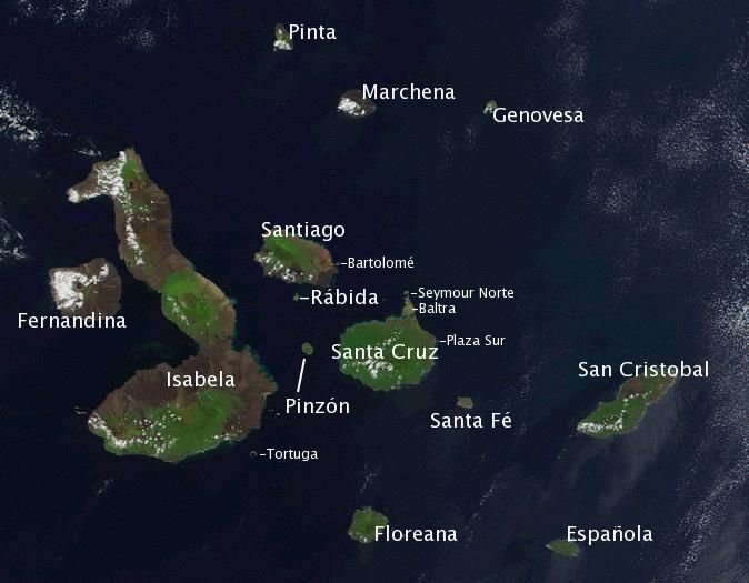
| விளக்கம் | Satellite photo of the Galapagos islands overlayed with the Spanish names of the visible main islands. | ||||||||||
| மூலம் | Based on the public domain NASA satellite photo Image:Galapagos-satellite-2002.jpg. Island names on labels are from the Wikipedia article w:en:Galápagos Islands and placed to the best of the author's knowledge. | ||||||||||
| ஆசிரியர் | labeled by Storpilot | ||||||||||
| அனுமதி (இக்கோப்பை மீண்டும் பயன்படுத்துதல்) |
|
||||||||||
| ஒத்தக்கோப்பு |
 |

அனுமதி
| I, the copyright holder of this work, release this work into the public domain. This applies worldwide. சில நாடுகளில் இது சாத்தியமில்லாது போகலாம். அவ்வாறாயின் : I grant anyone the right to use this work for any purpose, without any conditions, unless such conditions are required by law. |
கோப்பின் வரலாறு
குறித்த நேரத்தில் இருந்த படிமத்தைப் பார்க்க அந்நேரத்தின் மீது சொடுக்கவும்.
| நாள்/நேரம் | நகம் அளவு சிறுபடம் | அளவுகள் | பயனர் | கருத்து | |
|---|---|---|---|---|---|
| தற்போதைய | 15:57, 19 சனவரி 2006 | | 674 × 525 (48 KB) | Storpilot | Description: Satellite photo of the Galapagos islands overlayed with the Spanish names of the visible main islands. Source: Based on the public domain NASA satellite photo Image:Galapagos-EO.jpg. Island names on labels are from the Wikipedia article |
கோப்பு பயன்பாடு
பின்வரும் பக்க இணைப்புகள் இப் படிமத்துக்கு இணைக்கபட்டுள்ளது(ளன):
கோப்பின் முழுமையான பயன்பாடு
கீழ்கண்ட மற்ற விக்கிகள் இந்த கோப்பை பயன்படுத்துகின்றன:
- ar.wikipedia.org-திட்டத்தில் இதன் பயன்பாடு
- ban.wikipedia.org-திட்டத்தில் இதன் பயன்பாடு
- ba.wikipedia.org-திட்டத்தில் இதன் பயன்பாடு
- bg.wikipedia.org-திட்டத்தில் இதன் பயன்பாடு
- bs.wikipedia.org-திட்டத்தில் இதன் பயன்பாடு
- ca.wikipedia.org-திட்டத்தில் இதன் பயன்பாடு
- ceb.wikipedia.org-திட்டத்தில் இதன் பயன்பாடு
- cy.wikipedia.org-திட்டத்தில் இதன் பயன்பாடு
- da.wikipedia.org-திட்டத்தில் இதன் பயன்பாடு
- el.wikipedia.org-திட்டத்தில் இதன் பயன்பாடு
- en.wikipedia.org-திட்டத்தில் இதன் பயன்பாடு
- en.wikiversity.org-திட்டத்தில் இதன் பயன்பாடு
- en.wiktionary.org-திட்டத்தில் இதன் பயன்பாடு
- es.wikipedia.org-திட்டத்தில் இதன் பயன்பாடு
- et.wikipedia.org-திட்டத்தில் இதன் பயன்பாடு
- eu.wikipedia.org-திட்டத்தில் இதன் பயன்பாடு
- fa.wikipedia.org-திட்டத்தில் இதன் பயன்பாடு
- fi.wikipedia.org-திட்டத்தில் இதன் பயன்பாடு
சிறப்பு பக்கம்-மொத்த பயன்பாடு - இதன் மூலம் இந்த கோப்பின் மொத்த பயன்பாட்டை அறிய முடியும்