படிமம்:Ghaznavid Empire 975 - 1187 (AD).PNG
இதைவிட அளவில் பெரிய படிமம் இல்லை.
Ghaznavid_Empire_975_-_1187_(AD).PNG (620 × 428 படவணுக்கள், கோப்பின் அளவு: 20 KB, MIME வகை: image/png)
| இது விக்கிமீடியா பொதுக்கோப்பகத்தில் இருக்கும் ஒரு கோப்பாகும். இக்கோப்பைக் குறித்து அங்கே காணப்படும் படிம விளக்கப் பக்கத்தை இங்கே கீழே காணலாம்.
|
.PNG)
சுருக்கம்
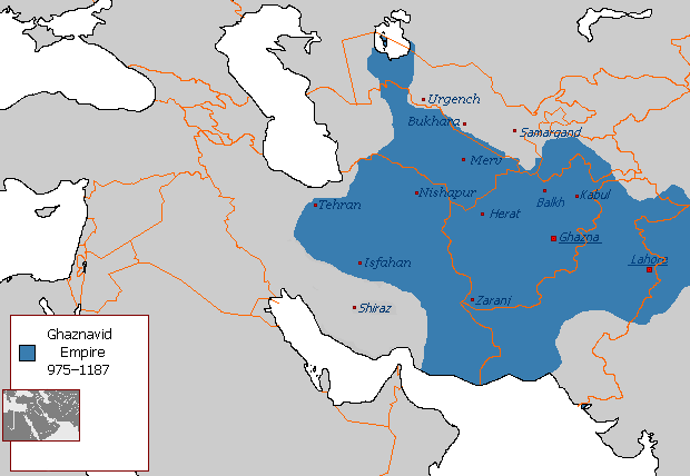
| விளக்கம் |
Polski: Państwo Ghaznawidów
English: Ghaznavid Empire |
| நாள் | |
| மூலம் | சொந்த முயற்சி |
| ஆசிரியர் | Arab League |
| ஒத்தக்கோப்பு | Arabic |
-ar.PNG)
அனுமதி
| This work has been released into the public domain by its author, Arab League at ஆங்கிலம் விக்கிப்பீடியா. This applies worldwide. சில நாடுகளில் இது சாத்தியமில்லாது போகலாம். அவ்வாறாயின் : Arab League grants anyone the right to use this work for any purpose, without any conditions, unless such conditions are required by law. |
கோப்பின் வரலாறு
குறித்த நேரத்தில் இருந்த படிமத்தைப் பார்க்க அந்நேரத்தின் மீது சொடுக்கவும்.
.PNG&dir=prev)
.PNG&offset=20130607145450)
.PNG&offset=&limit=20)
.PNG&offset=&limit=50)
.PNG&offset=&limit=100)
.PNG&offset=&limit=250)
.PNG&offset=&limit=500)
| நாள்/நேரம் | நகம் அளவு சிறுபடம் | அளவுகள் | பயனர் | கருத்து | |
|---|---|---|---|---|---|
| தற்போதைய | 04:54, 7 சூலை 2015 | | 620 × 428 (20 KB) | HistoryofIran | Of course Iranica doesn't, it states which areas they ruled at their extent, stop making reverts without discussing.. |
| 01:05, 4 சூலை 2015 |  | 619 × 428 (21 KB) | Persia10101 | More accurate map after some research | |
| 01:05, 4 சூலை 2015 |  | 619 × 428 (21 KB) | Persia10101 | More accurate map after some research | |
| 00:58, 4 சூலை 2015 |  | 620 × 428 (26 KB) | Persia10101 | Iranica doesnt show a map. reverting to the more commonly agreed map | |
| 00:57, 4 சூலை 2015 |  | 620 × 428 (26 KB) | Persia10101 | Reverted to version as of 08:05, 14 August 2011 | |
| 12:08, 9 மே 2014 |  | 620 × 428 (20 KB) | HistoryofIran | Further fixed the map, i will be adding vassals later. | |
| 23:47, 28 சனவரி 2014 |  | 620 × 428 (20 KB) | HistoryofIran | Fars and Kerman remained under Buyid rule until the Seljuqs came. | |
| 15:01, 7 சூன் 2013 |  | 620 × 428 (20 KB) | HistoryofIran | Fixed the map, according to Iranica the map was like this at it's greatest extent. | |
| 14:58, 7 சூன் 2013 |  | 620 × 428 (20 KB) | HistoryofIran | Fixed the map, according to Iranica the map was like this at it's greatest extent. | |
| 14:54, 7 சூன் 2013 |  | 620 × 428 (20 KB) | HistoryofIran | Fixed the map, according to Iranica the map was like this at it's greatest extent. |
கோப்பு பயன்பாடு
பின்வரும் 4 பக்கங்கள் இணைப்பு இப் படிமத்துக்கு இணைக்கபட்டுள்ளது(ளன):
கோப்பின் முழுமையான பயன்பாடு
கீழ்கண்ட மற்ற விக்கிகள் இந்த கோப்பை பயன்படுத்துகின்றன:
- arz.wikipedia.org-திட்டத்தில் இதன் பயன்பாடு
- ast.wikipedia.org-திட்டத்தில் இதன் பயன்பாடு
- av.wikipedia.org-திட்டத்தில் இதன் பயன்பாடு
- azb.wikipedia.org-திட்டத்தில் இதன் பயன்பாடு
- az.wikipedia.org-திட்டத்தில் இதன் பயன்பாடு
- ba.wikipedia.org-திட்டத்தில் இதன் பயன்பாடு
- be.wikipedia.org-திட்டத்தில் இதன் பயன்பாடு
- bg.wikipedia.org-திட்டத்தில் இதன் பயன்பாடு
- bn.wikipedia.org-திட்டத்தில் இதன் பயன்பாடு
- ca.wikipedia.org-திட்டத்தில் இதன் பயன்பாடு
- ceb.wikipedia.org-திட்டத்தில் இதன் பயன்பாடு
- ckb.wikipedia.org-திட்டத்தில் இதன் பயன்பாடு
- da.wikipedia.org-திட்டத்தில் இதன் பயன்பாடு
- de.wikipedia.org-திட்டத்தில் இதன் பயன்பாடு
- el.wikipedia.org-திட்டத்தில் இதன் பயன்பாடு
- en.wikipedia.org-திட்டத்தில் இதன் பயன்பாடு
- Muslim conquests of Afghanistan
- History of Afghanistan
- Turkic peoples
- Greater Iran
- Jasrota
- User:Arab Hafez/Map
- Portal:Afghanistan
- Shia Islam in the Indian subcontinent
- User:Ottava Rima/Persian Empire
- User:Sobreira/Religion
- Muslim conquest of Khorasan
- Nurpur kingdom
- User:Northamerica1000/Portals of the world
- User:Kansas Bear/Ghaznavids
- User:Kypioys sx/sandbox
- User:Kansas Bear/Saffarid dynasty
- eo.wikipedia.org-திட்டத்தில் இதன் பயன்பாடு
- es.wikipedia.org-திட்டத்தில் இதன் பயன்பாடு
சிறப்பு பக்கம்-மொத்த பயன்பாடு - இதன் மூலம் இந்த கோப்பின் மொத்த பயன்பாட்டை அறிய முடியும்
.PNG)
.PNG)