படிமம்:India1837to1857.jpg

இந்த முன்னோட்டத்தின் அளவு: 771 × 600 படப்புள்ளிகள் . மற்ற பிரிதிறன்கள்: 309 × 240 படப்புள்ளிகள் | 617 × 480 படப்புள்ளிகள் | 988 × 768 படப்புள்ளிகள் | 1,232 × 958 படப்புள்ளிகள் .
மூலக்கோப்பு (1,232 × 958 படவணுக்கள், கோப்பின் அளவு: 323 KB, MIME வகை: image/jpeg)
| இது விக்கிமீடியா பொதுக்கோப்பகத்தில் இருக்கும் ஒரு கோப்பாகும். இக்கோப்பைக் குறித்து அங்கே காணப்படும் படிம விளக்கப் பக்கத்தை இங்கே கீழே காணலாம்.
|
| விளக்கம் |
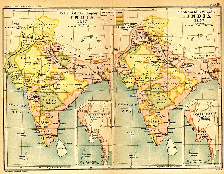
English: Image of map of India under the British East India Company, comparing 1837 with 1857 |
|||||
| நாள் | ||||||
| மூலம் | Imperial Gazetteer of India, Secretary of State for India in Council, OUP, 1907. Scanned from personal copy Fowler&fowler, 2007 | |||||
| ஆசிரியர் | Edinburgh Geographical Institute. | |||||
| அனுமதி (இக்கோப்பை மீண்டும் பயன்படுத்துதல்) |
|

கோப்பின் வரலாறு
குறித்த நேரத்தில் இருந்த படிமத்தைப் பார்க்க அந்நேரத்தின் மீது சொடுக்கவும்.
| நாள்/நேரம் | நகம் அளவு சிறுபடம் | அளவுகள் | பயனர் | கருத்து | |
|---|---|---|---|---|---|
| தற்போதைய | 16:07, 30 ஏப்பிரல் 2013 | | 1,232 × 958 (323 KB) | Gz deleted | {{Information |Description=Indian map |Source=en wiki |Date=unknown |Author=unknown |Permission={{GFDL-user-w|||User:Fowler&fowler}} |other_versions= }} |
கோப்பு பயன்பாடு
பின்வரும் பக்க இணைப்புகள் இப் படிமத்துக்கு இணைக்கபட்டுள்ளது(ளன):
கோப்பின் முழுமையான பயன்பாடு
கீழ்கண்ட மற்ற விக்கிகள் இந்த கோப்பை பயன்படுத்துகின்றன:
- ar.wikipedia.org-திட்டத்தில் இதன் பயன்பாடு
- azb.wikipedia.org-திட்டத்தில் இதன் பயன்பாடு
- cs.wikipedia.org-திட்டத்தில் இதன் பயன்பாடு
- el.wikipedia.org-திட்டத்தில் இதன் பயன்பாடு
- en.wikipedia.org-திட்டத்தில் இதன் பயன்பாடு
- fr.wikipedia.org-திட்டத்தில் இதன் பயன்பாடு
- incubator.wikimedia.org-திட்டத்தில் இதன் பயன்பாடு
- pnb.wikipedia.org-திட்டத்தில் இதன் பயன்பாடு
- pt.wikipedia.org-திட்டத்தில் இதன் பயன்பாடு
- sl.wikipedia.org-திட்டத்தில் இதன் பயன்பாடு
- te.wikipedia.org-திட்டத்தில் இதன் பயன்பாடு
- th.wikipedia.org-திட்டத்தில் இதன் பயன்பாடு
- ur.wikipedia.org-திட்டத்தில் இதன் பயன்பாடு