படிமம்:Internet map in February 82.jpg
இந்த முன்னோட்டத்தின் அளவு: 456 × 599 படப்புள்ளிகள் . மற்ற பிரிதிறன்கள்: 183 × 240 படப்புள்ளிகள் | 365 × 480 படப்புள்ளிகள் | 832 × 1,093 படப்புள்ளிகள் .
மூலக்கோப்பு (832 × 1,093 படவணுக்கள், கோப்பின் அளவு: 144 KB, MIME வகை: image/jpeg)
| இது விக்கிமீடியா பொதுக்கோப்பகத்தில் இருக்கும் ஒரு கோப்பாகும். இக்கோப்பைக் குறித்து அங்கே காணப்படும் படிம விளக்கப் பக்கத்தை இங்கே கீழே காணலாம்.
|
சுருக்கம்
| விளக்கம் |
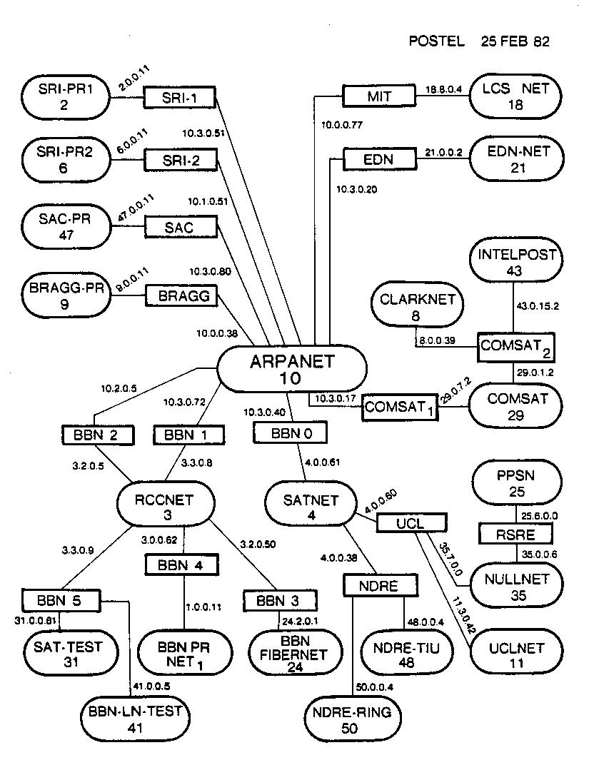
English: Contemporary map of the entire Internet in semi-production phase (many hosts attached to the ARPANET were still using NCP at this point) in February 1982. The ovals are sites/networks (some sites included more than one physical network), the rectangles are individual routers. No individual hosts are shown. Drawn by Jon Postel of the Information Sciences Institute, under a DARPA research contract as part of Internet development.
Deutsch: Eine Zeitgenössische Entwurfsansicht des gesamten Internets im Februar 1982. Die Ovale bezeichnen Sites/Netzwerke (einige bestehen dabei aus mehreren Physikalischen Netzwerken), die Rechtecke stellen individuelle Router dar, einzelne Hosts werden nicht dargestellt. Gezeichnet von Jon Postel vom Information Sciences Institute, unter dem DARPA research contract als Teil der Internet Entwicklung.
Español: Mapa contemporáneo de Internet en fase de semi-producción (varios hosts unidos a ARPANET cuando aún se usaba el NCP) en Febrero de 1982. Los óvalos son sitios/conexiones (algunos sitios incluían más de una conexión física), los rectángulos son routers individuales. No se muestran los hosts individuales. Dibujado por Jon Postel del Instituto de Ciencias de la Computación, bajo un contrato de investigación como parte del desarrollo de Internet.
Français : Vue schématique d’Internet, alors en phase de semi-production, datant de février 1982. A cette époque, NCP était encore largement utilisé par les systèmes connectés à ARPANET. Les ovales représentent des sites ou réseaux (certains sites étant constitués de plusieurs réseaux physiques) alors que les rectangles identifient les routeurs. Les ordinateurs hôtes ne sont pas représentés. Dessiné par Jon Postel, en poste à l’Institut des sciences informatiques (Information Sciences Institute, au sein de l’Université de Californie du Sud), contribuant au développement d’Internet dans le cadre d’un contrat de recherche de la DARPA.
Italiano: Rappresentazione della rete internet nel febbraio 1982. Gli ovali rappresentano siti/reti (alcune costituite da più reti fisiche) mentre i rettangoli sono i singoli router. I singoli host non sono rappresentati. Disegno realizzato da Jon Postel nell'ambito di un programma di ricerca della DARPA sullo sviluppo di internet.
Magyar: Egy korabeli térkép a teljes akkori internetről; a kerek dobozkák a különbözű helyi hálózatokat jelölik, míg szögletesek az ezek közti útválasztókat. |
| நாள் |
English: Uploaded to English Wikipedia on 30th August 2005 by Jnc, from English Wikipedia — uploaded to Commons on 17th February 2006 by Nethac DIU, from Spanish Wikipedia. Renamed on Saturday 29 July 2006.
Deutsch: Hochgeladen in das Englische Wikipedia am 30. August 2005 von Jnc, vom Englischen Wikipedia — Bei Commons hochgeladen am 17. Februar 2006 von Nethac DIU, aus dem Spanischen Wikipedia. Umbenannt am Samstag den 29. Juli 2006.
Español: Subido a la Wikipedia inglesa en 30 de Agosto de 2005 por Jnc, de la Wikipedia Inglesa; subida a Commons el 17 de Febrero de 2006 por Nethac DIU, de la Wikipedia Española. Renombrada el sábado 29 de julio de 2006
Français : Ajouté à la version anglaise de Wikipedia le 30 août 2005 par Jnc (Wikipedia en anglais). Ajouté aux Commons le 17 février 2006 par Nethac DIU (Wikipedia en espagnol). Renommé le 29 juillet 2006. |
| மூலம் |
English: Information Sciences Institute
Français : Institut des sciences informatiques (Information Sciences Institute, établissement de l’Université de Californie du Sud) |
| ஆசிரியர் | Jon Postel |
| அனுமதி (இக்கோப்பை மீண்டும் பயன்படுத்துதல்) |
PD-USGov-Military |
| ஒத்தக்கோப்பு |
  |
Template loop detected: Template:Autotranslate <includeonly></includeonly>
அனுமதி
This image is a work of a U.S. military or Department of Defense employee, taken or made as part of that person's official duties. As a work of the U.S. federal government, the image is in the public domain in the United States.
|
 |
கோப்பின் வரலாறு
குறித்த நேரத்தில் இருந்த படிமத்தைப் பார்க்க அந்நேரத்தின் மீது சொடுக்கவும்.
| நாள்/நேரம் | நகம் அளவு சிறுபடம் | அளவுகள் | பயனர் | கருத்து | |
|---|---|---|---|---|---|
| தற்போதைய | 10:08, 29 சூலை 2006 | | 832 × 1,093 (144 KB) | Nethac DIU | ==Summary== {{Information |Description = {{en|Contemporary map of the entire Internet in semi-production phase (many hosts attached to the ARPANET were still using NCP at this point) in February 1982. The ovals |
கோப்பு பயன்பாடு
பின்வரும் பக்க இணைப்புகள் இப் படிமத்துக்கு இணைக்கபட்டுள்ளது(ளன):
கோப்பின் முழுமையான பயன்பாடு
கீழ்கண்ட மற்ற விக்கிகள் இந்த கோப்பை பயன்படுத்துகின்றன:
- he.wikipedia.org-திட்டத்தில் இதன் பயன்பாடு
- pt.wikipedia.org-திட்டத்தில் இதன் பயன்பாடு