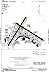
படிமம்:LGA Airport Diagram.svg

Size of this PNG preview of this SVG file: 378 × 552 படப்புள்ளிகள். மற்ற பிரிதிறன்கள்: 164 × 240 படப்புள்ளிகள் | 329 × 480 படப்புள்ளிகள் | 526 × 768 படப்புள்ளிகள் | 701 × 1,024 படப்புள்ளிகள் | 1,402 × 2,048 படப்புள்ளிகள் .
மூலக்கோப்பு (SVG கோப்பு, பெயரளவில் 378 × 552 பிக்சல்கள், கோப்பு அளவு: 781 KB)
| இது விக்கிமீடியா பொதுக்கோப்பகத்தில் இருக்கும் ஒரு கோப்பாகும். இக்கோப்பைக் குறித்து அங்கே காணப்படும் படிம விளக்கப் பக்கத்தை இங்கே கீழே காணலாம்.
|
சுருக்கம்
| விளக்கம் |
English: FAA Airport Diagram of LaGuardia Airport |
| நாள் | |
| மூலம் |
FAA Airport Diagrams; note that these change every 28 days. Taken from PDF on FAA site and converted to SVG using en:Wikipedia:How to draw SVG circuits using Xcircuit. |
| ஆசிரியர் | Produced by the National Aeronautical Charting Office (NACO), a department of the United States en:Federal Aviation Administration. |
| Camera location | | View this and other nearby images on: OpenStreetMap |
|---|
W3C-validity not checked.
அனுமதி
This image or file is a work of a Federal Aviation Administration employee, taken or made as part of that person's official duties. As a work of the U.S. federal government, the image is in the public domain in the United States.
|
 |
கோப்பின் வரலாறு
குறித்த நேரத்தில் இருந்த படிமத்தைப் பார்க்க அந்நேரத்தின் மீது சொடுக்கவும்.
| நாள்/நேரம் | நகம் அளவு சிறுபடம் | அளவுகள் | பயனர் | கருத்து | |
|---|---|---|---|---|---|
| தற்போதைய | 03:29, 2 மே 2013 | | 378 × 552 (781 KB) | Grendelkhan | SVG version of FAA's PDF diagram. |
கோப்பு பயன்பாடு
பின்வரும் பக்க இணைப்புகள் இப் படிமத்துக்கு இணைக்கபட்டுள்ளது(ளன):
கோப்பின் முழுமையான பயன்பாடு
கீழ்கண்ட மற்ற விக்கிகள் இந்த கோப்பை பயன்படுத்துகின்றன:
- mr.wikipedia.org-திட்டத்தில் இதன் பயன்பாடு
- new.wikipedia.org-திட்டத்தில் இதன் பயன்பாடு