படிமம்:LocationDominica.png
இதைவிட அளவில் பெரிய படிமம் இல்லை.
LocationDominica.png (290 × 133 படவணுக்கள், கோப்பின் அளவு: 4 KB, MIME வகை: image/png)
| இது விக்கிமீடியா பொதுக்கோப்பகத்தில் இருக்கும் ஒரு கோப்பாகும். இக்கோப்பைக் குறித்து அங்கே காணப்படும் படிம விளக்கப் பக்கத்தை இங்கே கீழே காணலாம்.
|
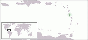
Location map for the Caribbean island-nation of Dominica.
Originally created for English Wikipedia by Vardion.
| |
This work has been released into the public domain by its author, Vardion, at the ஆங்கிலம் விக்கிப்பீடியா project. This applies worldwide. In case this is not legally possible: |
Template loop detected: Template:Autotranslate <includeonly></includeonly>.
கோப்பின் வரலாறு
குறித்த நேரத்தில் இருந்த படிமத்தைப் பார்க்க அந்நேரத்தின் மீது சொடுக்கவும்.
| நாள்/நேரம் | நகம் அளவு சிறுபடம் | அளவுகள் | பயனர் | கருத்து | |
|---|---|---|---|---|---|
| தற்போதைய | 17:58, 26 மார்ச்சு 2006 | | 290 × 133 (4 KB) | Stanmar | |
| 17:54, 26 மார்ச்சு 2006 |  | 290 × 133 (4 KB) | Stanmar | ||
| 02:31, 20 திசம்பர் 2004 |  | 250 × 115 (9 KB) | EugeneZelenko | Location map for the Dominica.<br/>Originally created for English Wikipedia by Vardion.<br/>{{PD}}<br/>Category:Country locator maps |
கோப்பு பயன்பாடு
பின்வரும் பக்க இணைப்புகள் இப் படிமத்துக்கு இணைக்கபட்டுள்ளது(ளன):
கோப்பின் முழுமையான பயன்பாடு
கீழ்கண்ட மற்ற விக்கிகள் இந்த கோப்பை பயன்படுத்துகின்றன:
- ar.wikipedia.org-திட்டத்தில் இதன் பயன்பாடு
- arz.wikipedia.org-திட்டத்தில் இதன் பயன்பாடு
- azb.wikipedia.org-திட்டத்தில் இதன் பயன்பாடு
- ba.wikipedia.org-திட்டத்தில் இதன் பயன்பாடு
- be-tarask.wikipedia.org-திட்டத்தில் இதன் பயன்பாடு
- be.wikipedia.org-திட்டத்தில் இதன் பயன்பாடு
- bg.wikipedia.org-திட்டத்தில் இதன் பயன்பாடு
- bn.wikipedia.org-திட்டத்தில் இதன் பயன்பாடு
- bo.wikipedia.org-திட்டத்தில் இதன் பயன்பாடு
- bpy.wikipedia.org-திட்டத்தில் இதன் பயன்பாடு
- bs.wikipedia.org-திட்டத்தில் இதன் பயன்பாடு
- ceb.wikipedia.org-திட்டத்தில் இதன் பயன்பாடு
- ckb.wikipedia.org-திட்டத்தில் இதன் பயன்பாடு
- da.wikipedia.org-திட்டத்தில் இதன் பயன்பாடு
- de.wiktionary.org-திட்டத்தில் இதன் பயன்பாடு
- dsb.wikipedia.org-திட்டத்தில் இதன் பயன்பாடு
- ee.wikipedia.org-திட்டத்தில் இதன் பயன்பாடு
- el.wiktionary.org-திட்டத்தில் இதன் பயன்பாடு
- en.wikipedia.org-திட்டத்தில் இதன் பயன்பாடு
- Geography of Dominica
- User:DanielZM/test
- User:TheGrappler/North America directory
- LGBT rights in Dominica
- Outline of Dominica
- Index of Dominica-related articles
- United Nations Security Council Resolution 442
- Anolis oculatus
- Dominican ground lizard
- List of amphibians and reptiles of Dominica
- List of non-marine molluscs of Dominica
- en.wikivoyage.org-திட்டத்தில் இதன் பயன்பாடு
- eo.wikipedia.org-திட்டத்தில் இதன் பயன்பாடு
- eo.wiktionary.org-திட்டத்தில் இதன் பயன்பாடு
- es.wikipedia.org-திட்டத்தில் இதன் பயன்பாடு
- es.wikinews.org-திட்டத்தில் இதன் பயன்பாடு
- eu.wikipedia.org-திட்டத்தில் இதன் பயன்பாடு
- eu.wiktionary.org-திட்டத்தில் இதன் பயன்பாடு
- ext.wikipedia.org-திட்டத்தில் இதன் பயன்பாடு
- fa.wikipedia.org-திட்டத்தில் இதன் பயன்பாடு
- fiu-vro.wikipedia.org-திட்டத்தில் இதன் பயன்பாடு
சிறப்பு பக்கம்-மொத்த பயன்பாடு - இதன் மூலம் இந்த கோப்பின் மொத்த பயன்பாட்டை அறிய முடியும்