படிமம்:Location map Peninsula Malaysia.png

மூலக்கோப்பு (539 × 656 படவணுக்கள், கோப்பின் அளவு: 449 KB, MIME வகை: image/png)
| இது விக்கிமீடியா பொதுக்கோப்பகத்தில் இருக்கும் ஒரு கோப்பாகும். இக்கோப்பைக் குறித்து அங்கே காணப்படும் படிம விளக்கப் பக்கத்தை இங்கே கீழே காணலாம்.
|

|
This locator map image could be re-created using vector graphics as an SVG file. This has several advantages; see Commons:Media for cleanup for more information. If an SVG form of this image is available, please upload it and afterwards replace this template with
{{vector version available|new image name}}.
It is recommended to name the SVG file “Location map Peninsula Malaysia.svg”—then the template Vector version available (or Vva) does not need the new image name parameter. |
சுருக்கம்
| விளக்கம் |
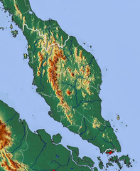
Relief map of Peninsula Malaysia Geographic limits of the map:
|
| நாள் | |
| மூலம் | http://www.maps-for-free.com/ |
| ஆசிரியர் | Modified by Dr. Blofeld |
| அனுமதி (இக்கோப்பை மீண்டும் பயன்படுத்துதல்) |
http://www.maps-for-free.com/html/about.html |
அனுமதி
இந்த ஸ்கிரீன்ஷாட் பதிப்புரிமை-தகுதி காப்புரிமை பெற்றது மென்பொருள்ளை பகுதிகள் அல்லது காட்சிகள் கொண்டிருக்கும் இல்லை, அல்லது ஆசிரியர் ஒரு இலவச உரிமம் கீழ் வெளியிட்டார் (இந்த அறிவிப்பின் கீழே எது குறிப்பிடப்பட வேண்டும்), மேலும் பின்வருமாறு, விக்கிமீடியா காமன்ஸின் உரிம வழிகாட்டுதல்கள். குறிப்பிட்ட உரிமத்தின்படி நீங்கள் அதை சுதந்திரமாகப் பயன்படுத்தலாம். இலவச மென்பொருள் உரிமம்:

|
This work is free software; you can redistribute it and/or modify it under the terms of the GNU General Public License as published by the Free Software Foundation; either version 2 of the License, or any later version. This work is distributed in the hope that it will be useful, but without any warranty; without even the implied warranty of merchantability or fitness for a particular purpose. See version 2 and version 3 of the GNU General Public License for more details. |
குறிப்பு: ஸ்கிரீன்ஷாட் நிரலின் ஒரு பகுதியாக இல்லாத உரை அல்லது கிராபிக்ஸ் போன்ற நிரல் குறியீட்டின் நேரடி விளைவாக இல்லாத எந்த வேலையையும் காட்டினால், அந்த வேலைக்கான உரிமம்
அனுமதி
- நீங்கள் சுதந்திரமாக:
- பகிர்ந்து கொள்ள – வேலையை நகலெடுக்க, விநியோகிக்க மற்றும் அனுப்ப
- மீண்டும் கலக்க – வேலைக்கு பழகிக்கொள்ள.
- கீழ்க்காணும் விதிகளுக்கு ஏற்ப,
- பண்புக்கூறுகள் – நீங்கள் பொருத்தமான உரிமையை வழங்க வேண்டும், உரிமத்திற்கான இணைப்பை வழங்க வேண்டும் மற்றும் மாற்றங்கள் செய்யப்பட்டிருந்தால் குறிப்பிட வேண்டும். நீங்கள் ஏற்புடைய எந்த முறையிலும் அவ்வாறு செய்யலாம், ஆனால் எந்த வகையிலும் உரிமதாரர் உங்களை அல்லது உங்கள் பயன்பாட்டிற்கு ஒப்புதல் அளிக்கும் படி பரிந்துரைக்க கூடாது.
கோப்பின் வரலாறு
குறித்த நேரத்தில் இருந்த படிமத்தைப் பார்க்க அந்நேரத்தின் மீது சொடுக்கவும்.
| நாள்/நேரம் | நகம் அளவு சிறுபடம் | அளவுகள் | பயனர் | கருத்து | |
|---|---|---|---|---|---|
| தற்போதைய | 11:58, 6 மார்ச்சு 2011 | | 539 × 656 (449 KB) | Blofeld Dr. | {{Information |Description ={{en|1=y}} |Source =y |Author =y |Date =y |Permission = |other_versions = }} |
கோப்பு பயன்பாடு
பின்வரும் பக்க இணைப்புகள் இப் படிமத்துக்கு இணைக்கபட்டுள்ளது(ளன):
கோப்பின் முழுமையான பயன்பாடு
கீழ்கண்ட மற்ற விக்கிகள் இந்த கோப்பை பயன்படுத்துகின்றன:
- bg.wikipedia.org-திட்டத்தில் இதன் பயன்பாடு
- bn.wikipedia.org-திட்டத்தில் இதன் பயன்பாடு
- da.wikipedia.org-திட்டத்தில் இதன் பயன்பாடு
- el.wikipedia.org-திட்டத்தில் இதன் பயன்பாடு
- en.wikipedia.org-திட்டத்தில் இதன் பயன்பாடு
- es.wikipedia.org-திட்டத்தில் இதன் பயன்பாடு
- fa.wikipedia.org-திட்டத்தில் இதன் பயன்பாடு
- fi.wikipedia.org-திட்டத்தில் இதன் பயன்பாடு
- haw.wikipedia.org-திட்டத்தில் இதன் பயன்பாடு
- id.wikipedia.org-திட்டத்தில் இதன் பயன்பாடு
- it.wikipedia.org-திட்டத்தில் இதன் பயன்பாடு
- ja.wikipedia.org-திட்டத்தில் இதன் பயன்பாடு
- jv.wikipedia.org-திட்டத்தில் இதன் பயன்பாடு
- ka.wikipedia.org-திட்டத்தில் இதன் பயன்பாடு
- ko.wikipedia.org-திட்டத்தில் இதன் பயன்பாடு
- pa.wikipedia.org-திட்டத்தில் இதன் பயன்பாடு
- pl.wikipedia.org-திட்டத்தில் இதன் பயன்பாடு
- sr.wikipedia.org-திட்டத்தில் இதன் பயன்பாடு
- th.wikipedia.org-திட்டத்தில் இதன் பயன்பாடு
- uk.wikipedia.org-திட்டத்தில் இதன் பயன்பாடு
- vep.wikipedia.org-திட்டத்தில் இதன் பயன்பாடு
- zh-yue.wikipedia.org-திட்டத்தில் இதன் பயன்பாடு
- zh.wikipedia.org-திட்டத்தில் இதன் பயன்பாடு