படிமம்:Location of Lugansk People's Republic.png
இந்த முன்னோட்டத்தின் அளவு: 800 × 586 படப்புள்ளிகள் . மற்ற பிரிதிறன்கள்: 320 × 234 படப்புள்ளிகள் | 640 × 469 படப்புள்ளிகள் | 1,024 × 750 படப்புள்ளிகள் | 1,280 × 938 படப்புள்ளிகள் | 1,694 × 1,241 படப்புள்ளிகள் .
மூலக்கோப்பு (1,694 × 1,241 படவணுக்கள், கோப்பின் அளவு: 956 KB, MIME வகை: image/png)
| இது விக்கிமீடியா பொதுக்கோப்பகத்தில் இருக்கும் ஒரு கோப்பாகும். இக்கோப்பைக் குறித்து அங்கே காணப்படும் படிம விளக்கப் பக்கத்தை இங்கே கீழே காணலாம்.
|

|
This locator map image could be re-created using vector graphics as an SVG file. This has several advantages; see Commons:Media for cleanup for more information. If an SVG form of this image is available, please upload it and afterwards replace this template with
{{vector version available|new image name}}.
It is recommended to name the SVG file “Location of Lugansk People's Republic.svg”—then the template Vector version available (or Vva) does not need the new image name parameter. |
சுருக்கம்
| விளக்கம் |
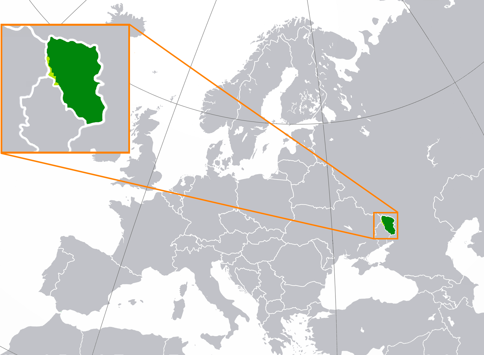
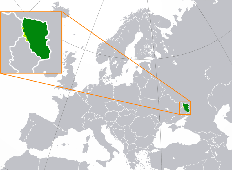
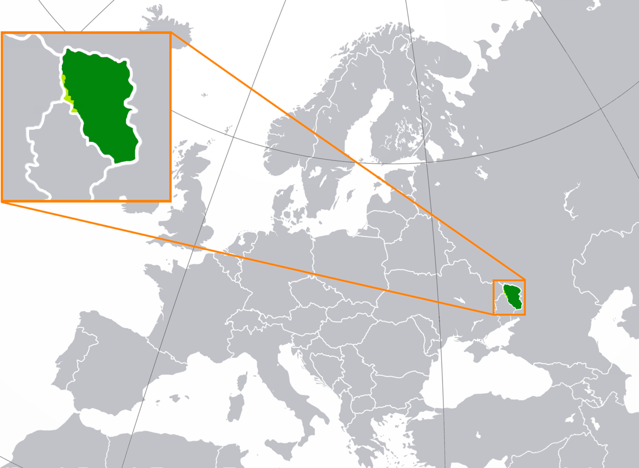
Русский: Луганская Народная Республика на карте Европы
English: territory controlled by the self-proclaimed Lugansk People's Republic (dark green) inside of the Luhansk Oblast (light green)
Français : Territoire contrôlé par la République populaire de Lougansk (vert foncé) à l'intérieur de l'oblast de Louhansk (vert clair)
Deutsch: Kontrollierte Gebiete der nicht anerkannten de:Volksrepublik Lugansk (dunkelgrün) innerhalb der de:Oblast Luhansk (hellgrün) |
| நாள் | |
| மூலம் | சொந்த முயற்சி |
| ஆசிரியர் | Nicolay Sidorov |
| ஒத்தக்கோப்பு | Derivative works of this file: Location of Lugansk People's Republic (before 2022 invasion).png |
.png)

|
This file may be updated to reflect new information. If you wish to use a specific version of the file without new updates being mirrored, please upload the required version as a separate file. |
அனுமதி
இந்த ஆக்கத்தின் காப்புரிமையாளரான நான் இதனைப் பின்வரும் உரிமத்தின் கீழ் வெளியிடுகின்றேன்:
இந்த கோப்பு Creative Commons Attribution-Share Alike 3.0 Unported உரிமத்தின் கீழ் உள்ளது.
- நீங்கள் சுதந்திரமாக:
- பகிர்ந்து கொள்ள – வேலையை நகலெடுக்க, விநியோகிக்க மற்றும் அனுப்ப
- மீண்டும் கலக்க – வேலைக்கு பழகிக்கொள்ள.
- கீழ்க்காணும் விதிகளுக்கு ஏற்ப,
- பண்புக்கூறுகள் – நீங்கள் பொருத்தமான உரிமையை வழங்க வேண்டும், உரிமத்திற்கான இணைப்பை வழங்க வேண்டும் மற்றும் மாற்றங்கள் செய்யப்பட்டிருந்தால் குறிப்பிட வேண்டும். நீங்கள் ஏற்புடைய எந்த முறையிலும் அவ்வாறு செய்யலாம், ஆனால் எந்த வகையிலும் உரிமதாரர் உங்களை அல்லது உங்கள் பயன்பாட்டிற்கு ஒப்புதல் அளிக்கும் படி பரிந்துரைக்க கூடாது.
- அதே மாதிரி பகிர் – நீங்கள் ரீமிக்ஸ் செய்தாலோ, உருமாற்றம் செய்தாலோ அல்லது பொருளை உருவாக்கினாலோ, உங்கள் பங்களிப்புகளை அல்லது இணக்கமான உரிமம் கீழ் அசலாக விநியோகிக்க வேண்டும்.
கோப்பின் வரலாறு
குறித்த நேரத்தில் இருந்த படிமத்தைப் பார்க்க அந்நேரத்தின் மீது சொடுக்கவும்.
| நாள்/நேரம் | நகம் அளவு சிறுபடம் | அளவுகள் | பயனர் | கருத்து | |
|---|---|---|---|---|---|
| தற்போதைய | 03:06, 28 சனவரி 2023 | | 1,694 × 1,241 (956 KB) | DinoSoupCanada | ...still needs to be updated once in a while |
| 11:45, 28 நவம்பர் 2022 |  | 1,694 × 1,241 (796 KB) | Durranistan | change map per [https://commons.wikimedia.org/wiki/File:War_for_donbass_24-6-2022.svg war in Donbas] | |
| 19:36, 13 நவம்பர் 2022 |  | 1,694 × 1,241 (765 KB) | DinoSoupCanada | Since the article is repurposed as a disputed subject of Russia, then it's fine to edit again. | |
| 13:35, 10 அக்டோபர் 2022 |  | 1,694 × 1,241 (733 KB) | DinoSoupCanada | Reverted to version as of 01:16, 1 October 2022 (UTC) | |
| 22:02, 6 அக்டோபர் 2022 |  | 1,694 × 1,241 (765 KB) | DinoSoupCanada | Update | |
| 01:16, 1 அக்டோபர் 2022 |  | 1,694 × 1,241 (733 KB) | Nahabino | Update per ISW | |
| 00:20, 29 செப்டெம்பர் 2022 |  | 1,694 × 1,241 (733 KB) | Nahabino | better contour | |
| 09:23, 26 செப்டெம்பர் 2022 |  | 1,694 × 1,241 (762 KB) | Durranistan | update per File:Rebel occupied Luhansk Oblast'.png | |
| 00:57, 20 செப்டெம்பர் 2022 |  | 1,694 × 1,241 (669 KB) | Nahabino | Little cleaning | |
| 21:44, 31 சூலை 2022 |  | 1,694 × 1,241 (698 KB) | Chipmunkdavis | Reverted to version as of 05:53, 5 July 2022 (UTC) This file is originally a location map (see also the file name). |
கோப்பு பயன்பாடு
பின்வரும் பக்க இணைப்புகள் இப் படிமத்துக்கு இணைக்கபட்டுள்ளது(ளன):
கோப்பின் முழுமையான பயன்பாடு
கீழ்கண்ட மற்ற விக்கிகள் இந்த கோப்பை பயன்படுத்துகின்றன:
- af.wikipedia.org-திட்டத்தில் இதன் பயன்பாடு
- azb.wikipedia.org-திட்டத்தில் இதன் பயன்பாடு
- be.wikipedia.org-திட்டத்தில் இதன் பயன்பாடு
- bg.wikipedia.org-திட்டத்தில் இதன் பயன்பாடு
- bh.wikipedia.org-திட்டத்தில் இதன் பயன்பாடு
- bn.wikipedia.org-திட்டத்தில் இதன் பயன்பாடு
- br.wikipedia.org-திட்டத்தில் இதன் பயன்பாடு
- bs.wikipedia.org-திட்டத்தில் இதன் பயன்பாடு
- ckb.wikipedia.org-திட்டத்தில் இதன் பயன்பாடு
- cs.wikipedia.org-திட்டத்தில் இதன் பயன்பாடு
- cv.wikipedia.org-திட்டத்தில் இதன் பயன்பாடு
- el.wikipedia.org-திட்டத்தில் இதன் பயன்பாடு
- en.wikipedia.org-திட்டத்தில் இதன் பயன்பாடு
- eo.wikipedia.org-திட்டத்தில் இதன் பயன்பாடு
- es.wikipedia.org-திட்டத்தில் இதன் பயன்பாடு
- et.wikipedia.org-திட்டத்தில் இதன் பயன்பாடு
- ext.wikipedia.org-திட்டத்தில் இதன் பயன்பாடு
- fa.wikipedia.org-திட்டத்தில் இதன் பயன்பாடு
- fr.wikipedia.org-திட்டத்தில் இதன் பயன்பாடு
- he.wikipedia.org-திட்டத்தில் இதன் பயன்பாடு
- hi.wikipedia.org-திட்டத்தில் இதன் பயன்பாடு
- hr.wikipedia.org-திட்டத்தில் இதன் பயன்பாடு
- hsb.wikipedia.org-திட்டத்தில் இதன் பயன்பாடு
- hu.wikipedia.org-திட்டத்தில் இதன் பயன்பாடு
- id.wikipedia.org-திட்டத்தில் இதன் பயன்பாடு
- ie.wikipedia.org-திட்டத்தில் இதன் பயன்பாடு
- is.wikipedia.org-திட்டத்தில் இதன் பயன்பாடு
- it.wikipedia.org-திட்டத்தில் இதன் பயன்பாடு
- ja.wikipedia.org-திட்டத்தில் இதன் பயன்பாடு
- ka.wikipedia.org-திட்டத்தில் இதன் பயன்பாடு
- kk.wikipedia.org-திட்டத்தில் இதன் பயன்பாடு
- ko.wikipedia.org-திட்டத்தில் இதன் பயன்பாடு
- kv.wikipedia.org-திட்டத்தில் இதன் பயன்பாடு
- lez.wikipedia.org-திட்டத்தில் இதன் பயன்பாடு
- lij.wikipedia.org-திட்டத்தில் இதன் பயன்பாடு
- lt.wikipedia.org-திட்டத்தில் இதன் பயன்பாடு
- lv.wikipedia.org-திட்டத்தில் இதன் பயன்பாடு
- mk.wikipedia.org-திட்டத்தில் இதன் பயன்பாடு
- ml.wikipedia.org-திட்டத்தில் இதன் பயன்பாடு
- ms.wikipedia.org-திட்டத்தில் இதன் பயன்பாடு
- nl.wikipedia.org-திட்டத்தில் இதன் பயன்பாடு
- pl.wikipedia.org-திட்டத்தில் இதன் பயன்பாடு
- pl.wiktionary.org-திட்டத்தில் இதன் பயன்பாடு
சிறப்பு பக்கம்-மொத்த பயன்பாடு - இதன் மூலம் இந்த கோப்பின் மொத்த பயன்பாட்டை அறிய முடியும்