படிமம்:Menelik II conquests map on world sphere.svg

Size of this PNG preview of this SVG file: 550 × 550 படப்புள்ளிகள். மற்ற பிரிதிறன்கள்: 240 × 240 படப்புள்ளிகள் | 480 × 480 படப்புள்ளிகள் | 768 × 768 படப்புள்ளிகள் | 1,024 × 1,024 படப்புள்ளிகள் | 2,048 × 2,048 படப்புள்ளிகள் .
மூலக்கோப்பு (SVG கோப்பு, பெயரளவில் 550 × 550 பிக்சல்கள், கோப்பு அளவு: 134 KB)
| இது விக்கிமீடியா பொதுக்கோப்பகத்தில் இருக்கும் ஒரு கோப்பாகும். இக்கோப்பைக் குறித்து அங்கே காணப்படும் படிம விளக்கப் பக்கத்தை இங்கே கீழே காணலாம்.
|
| விளக்கம் |
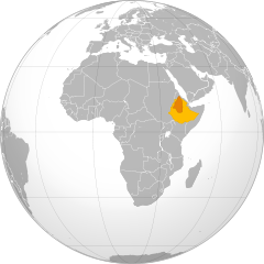
English: Ethiopian Empire's territorial expansion during Menelik II reign. Ethiopian Empire before conquests Ethiopian Empire after conquests Français : Expansion territoriale de l'empire éthiopien durant le règne de Menelik II Empire éthiopien avant les conquêtes Empire éthiopien après les conquêtes |
| நாள் | (UTC) |
| மூலம் | |
| ஆசிரியர் |
|
.svg)
.jpg)
Français : Cette carte a été créée par Pethrus d'après les sources mentionnés ci-dessus. Il s'agit d'un travail d'amateur, même s'il a été réalisé avec soin ; il peut comporter des inexactitudes ou des erreurs. Cette carte a donc un rôle d'illustration et non de référence. N'hésitez pas à me signaler toute erreur que vous constateriez ou à effectuer vous-même la correction. English: This map was drawn by Pethrus from sources mentionned above. Even if it was done with care, this is an amateur work ; there might be some inaccuracies or errors. As such, it should not be considered authoritative. Please contact me if you notice any mistake, and feel free to correct it yourself.
|

|
GNU Free Documentation License விதிமுறைகளின் கீழ் இந்த ஆவணத்தை நகலெடுக்க, விநியோகிக்க மற்றும்/அல்லது மாற்றுவதற்கு அனுமதி வழங்கப்பட்டுள்ளது, Free Software Foundation;ஆல் வெளியிடப்பட்ட பதிப்பு 1.2 அல்லது அதற்குப் பிந்தைய பதிப்பு, மாற்றமில்லாத பிரிவுகள், முன் அட்டை உரைகள் மற்றும் பின் அட்டை உரைகள் இல்லாமல் வெளியிடப்பட்டது. GNU Free Documentation License என்ற தலைப்பில் உரிமத்தின் நகல் சேர்க்கப்பட்டுள்ளது. |
இந்த கோப்பு Creative Commons Attribution-Share Alike 3.0 Unported உரிமத்தின் கீழ் உள்ளது.
- நீங்கள் சுதந்திரமாக:
- பகிர்ந்து கொள்ள – வேலையை நகலெடுக்க, விநியோகிக்க மற்றும் அனுப்ப
- மீண்டும் கலக்க – வேலைக்கு பழகிக்கொள்ள.
- கீழ்க்காணும் விதிகளுக்கு ஏற்ப,
- பண்புக்கூறுகள் – நீங்கள் பொருத்தமான உரிமையை வழங்க வேண்டும், உரிமத்திற்கான இணைப்பை வழங்க வேண்டும் மற்றும் மாற்றங்கள் செய்யப்பட்டிருந்தால் குறிப்பிட வேண்டும். நீங்கள் ஏற்புடைய எந்த முறையிலும் அவ்வாறு செய்யலாம், ஆனால் எந்த வகையிலும் உரிமதாரர் உங்களை அல்லது உங்கள் பயன்பாட்டிற்கு ஒப்புதல் அளிக்கும் படி பரிந்துரைக்க கூடாது.
- அதே மாதிரி பகிர் – நீங்கள் ரீமிக்ஸ் செய்தாலோ, உருமாற்றம் செய்தாலோ அல்லது பொருளை உருவாக்கினாலோ, உங்கள் பங்களிப்புகளை அல்லது இணக்கமான உரிமம் கீழ் அசலாக விநியோகிக்க வேண்டும்.
Original upload log
This image is a derivative work of the following images:
- File:Africa_(orthographic_projection).svg licensed with Cc-by-sa-3.0, GFDL
- 2009-12-26T12:16:07Z Sémhur 550x550 (134838 Bytes) + border Eritrea - Etiophia
- 2009-12-05T05:13:01Z Keepscases 550x550 (327726 Bytes) borders
- 2009-06-25T11:35:40Z Martin23230 541x541 (333490 Bytes) {{Information |Description={{en|1=Orthographic map of Africa}} |Source=Own work by uploader |Author=[[User:Martin23230|Martin23230]] |Date=2009-06-25 |Permission= |other_versions= }} [[Category:Orthographic projections]] [[
- File:Menelik_II_conquests_map.svg licensed with GFDL
- 2010-03-15T15:36:06Z Pethrus 772x705 (831590 Bytes) Borders fixes, background topographic image fix
- 2010-03-15T14:02:09Z Pethrus 772x705 (17951 Bytes) {{Information |Description={{en|Ethiopian Empire's territorial expansion during Menelik II reign. {{legend|#deca60|Ethiopian Empire before conquests}}{{legend|#f5b46f|Ethiopian Empire after conquests}}}} {{fr|1=Expansion ter
Uploaded with derivativeFX
கோப்பின் வரலாறு
குறித்த நேரத்தில் இருந்த படிமத்தைப் பார்க்க அந்நேரத்தின் மீது சொடுக்கவும்.
| நாள்/நேரம் | நகம் அளவு சிறுபடம் | அளவுகள் | பயனர் | கருத்து | |
|---|---|---|---|---|---|
| தற்போதைய | 17:28, 15 மார்ச்சு 2010 | | 550 × 550 (134 KB) | Pethrus | {{Information |Description={{en|Ethiopian Empire's territorial expansion during Menelik II reign. {{legend|#deca60|Ethiopian Empire before conquests}}{{legend|#c95e08|Ethiopian Empire after conquests}}}} {{fr|1=Expansion territoriale de l'empire éthiopi |
கோப்பு பயன்பாடு
பின்வரும் பக்க இணைப்புகள் இப் படிமத்துக்கு இணைக்கபட்டுள்ளது(ளன):
கோப்பின் முழுமையான பயன்பாடு
கீழ்கண்ட மற்ற விக்கிகள் இந்த கோப்பை பயன்படுத்துகின்றன:
- af.wikipedia.org-திட்டத்தில் இதன் பயன்பாடு
- az.wikipedia.org-திட்டத்தில் இதன் பயன்பாடு
- bg.wikipedia.org-திட்டத்தில் இதன் பயன்பாடு
- cv.wikipedia.org-திட்டத்தில் இதன் பயன்பாடு
- de.wikipedia.org-திட்டத்தில் இதன் பயன்பாடு
- en.wikipedia.org-திட்டத்தில் இதன் பயன்பாடு
- fr.wikipedia.org-திட்டத்தில் இதன் பயன்பாடு
- gl.wikipedia.org-திட்டத்தில் இதன் பயன்பாடு
- he.wikipedia.org-திட்டத்தில் இதன் பயன்பாடு
- hy.wikipedia.org-திட்டத்தில் இதன் பயன்பாடு
- id.wikipedia.org-திட்டத்தில் இதன் பயன்பாடு
- ko.wikipedia.org-திட்டத்தில் இதன் பயன்பாடு
- om.wikipedia.org-திட்டத்தில் இதன் பயன்பாடு
- sc.wikipedia.org-திட்டத்தில் இதன் பயன்பாடு
- sd.wikipedia.org-திட்டத்தில் இதன் பயன்பாடு
- simple.wikipedia.org-திட்டத்தில் இதன் பயன்பாடு
- sr.wikipedia.org-திட்டத்தில் இதன் பயன்பாடு
- th.wikipedia.org-திட்டத்தில் இதன் பயன்பாடு
- tr.wikipedia.org-திட்டத்தில் இதன் பயன்பாடு
- uk.wikipedia.org-திட்டத்தில் இதன் பயன்பாடு
- ur.wikipedia.org-திட்டத்தில் இதன் பயன்பாடு
- www.wikidata.org-திட்டத்தில் இதன் பயன்பாடு
- xmf.wikipedia.org-திட்டத்தில் இதன் பயன்பாடு