படிமம்:Mohammad adil-Rashidun-empire-at-its-peak-close.PNG
இந்த முன்னோட்டத்தின் அளவு: 800 × 388 படப்புள்ளிகள் . மற்ற பிரிதிறன்கள்: 320 × 155 படப்புள்ளிகள் | 640 × 310 படப்புள்ளிகள் | 1,196 × 580 படப்புள்ளிகள் .
மூலக்கோப்பு (1,196 × 580 படவணுக்கள், கோப்பின் அளவு: 58 KB, MIME வகை: image/png)
| இது விக்கிமீடியா பொதுக்கோப்பகத்தில் இருக்கும் ஒரு கோப்பாகும். இக்கோப்பைக் குறித்து அங்கே காணப்படும் படிம விளக்கப் பக்கத்தை இங்கே கீழே காணலாம்.
|

|
This map image could be re-created using vector graphics as an SVG file. This has several advantages; see Commons:Media for cleanup for more information. If an SVG form of this image is available, please upload it and afterwards replace this template with
{{vector version available|new image name}}.
It is recommended to name the SVG file “Mohammad adil-Rashidun-empire-at-its-peak-close.svg”—then the template Vector version available (or Vva) does not need the new image name parameter. |
சுருக்கம்
| விளக்கம் |
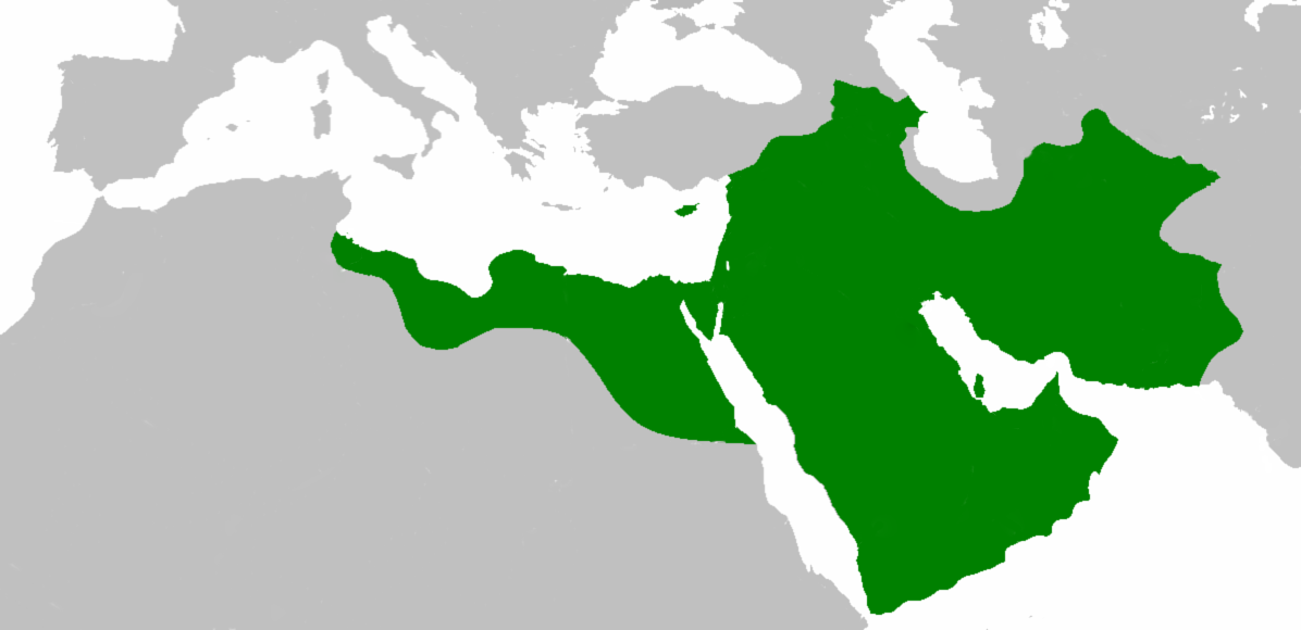
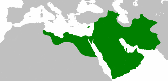
العربية: اتساع الدولة الإسلامية في عهد الخليفة عثمان بن عفان English: Empire of the Rashidun Caliphate at its peak. |
|||
| நாள் | 21 சூலை 2007 (original upload date) | |||
| மூலம் | Transferred from en.wikipedia to Commons. | |||
| ஆசிரியர் | Mohammad adil at ஆங்கிலம் விக்கிப்பீடியா | |||
| ஒத்தக்கோப்பு |
|

அனுமதி
இந்த ஆக்கத்தின் காப்புரிமையாளரான Mohammad adil from en.wikipedia.org எனும் நான் இதனைப் பின்வரும் உரிமத்தின் கீழ் வெளியிடுகின்றேன்:
| இந்த கோப்பு Creative Commons Attribution-Share Alike 3.0 Unported உரிமத்தின் கீழ் உள்ளது. Subject to disclaimers. | ||
| பண்புக்கூறுகள்: Mohammad adil from en.wikipedia.org | ||
| ||
| This licensing tag was added to this file as part of the GFDL licensing update. |

|
GNU Free Documentation License விதிமுறைகளின் கீழ் இந்த ஆவணத்தை நகலெடுக்க, விநியோகிக்க மற்றும்/அல்லது மாற்றுவதற்கு அனுமதி வழங்கப்பட்டுள்ளது, Free Software Foundation;ஆல் வெளியிடப்பட்ட பதிப்பு 1.2 அல்லது அதற்குப் பிந்தைய பதிப்பு, மாற்றமில்லாத பிரிவுகள், முன் அட்டை உரைகள் மற்றும் பின் அட்டை உரைகள் இல்லாமல் வெளியிடப்பட்டது. GNU Free Documentation License என்ற தலைப்பில் உரிமத்தின் நகல் சேர்க்கப்பட்டுள்ளது. Subject to disclaimers. |
Original upload log
The original description page was here. All following user names refer to en.wikipedia.
- 2010-04-25 09:06 Cplakidas 1196×580× (50435 bytes) whoops
- 2010-04-25 08:59 Cplakidas 1196×580× (50513 bytes) corrections: Crete, Rhodes, Sicily, Cilicia, W. Armenia & Iberia were raided and invaded, but not permanently occupied until much later. In Africa, the Exarchate of Carthage still controlled most of Tunisia, and no Arabs had yet reached Spain.
- 2009-05-01 06:26 Mohammad adil 1196×580× (46594 bytes) {{GFDL-self-with-disclaimers}}
- 2009-01-26 14:13 Mohammad adil 1196×580× (95308 bytes)
- 2008-03-28 21:12 Mohammad adil 1400×680× (48613 bytes) {{GFDL-self-with-disclaimers}}
- 2008-03-28 21:08 Mohammad adil 1400×680× (48472 bytes) {{GFDL-self-with-disclaimers}}
- 2007-07-21 19:15 Mohammad adil 1400×690× (47455 bytes) {{GFDL-self-with-disclaimers}}
கோப்பின் வரலாறு
குறித்த நேரத்தில் இருந்த படிமத்தைப் பார்க்க அந்நேரத்தின் மீது சொடுக்கவும்.
| நாள்/நேரம் | நகம் அளவு சிறுபடம் | அளவுகள் | பயனர் | கருத்து | |
|---|---|---|---|---|---|
| தற்போதைய | 19:59, 10 திசம்பர் 2018 | | 1,196 × 580 (58 KB) | عبد الله | Reverted to version as of 19:41, 10 December 2018 (UTC) |
| 19:57, 10 திசம்பர் 2018 |  | 1,196 × 580 (58 KB) | عبد الله | إزالة خطوط مزعجة | |
| 19:41, 10 திசம்பர் 2018 |  | 1,196 × 580 (58 KB) | عبد الله | إزالة خطوط مضايقة | |
| 04:29, 12 திசம்பர் 2017 |  | 1,196 × 580 (37 KB) | Swazzo | Reverted to version as of 23:30, 2 May 2014 (UTC) unnecessary | |
| 11:25, 9 திசம்பர் 2017 |  | 1,196 × 580 (44 KB) | Mehrdad 12 | [[]][[Media:]]]] | |
| 23:30, 2 மே 2014 |  | 1,196 × 580 (37 KB) | HistoryofIran | Corrected map; regions such as Ghur was not under Rashidun control. | |
| 09:27, 19 அக்டோபர் 2012 |  | 1,196 × 580 (45 KB) | Cplakidas | correction: the Muslims had not yet established themselves beyond the Caucasus, Derbent and its environs were conquered in the 8th century | |
| 08:51, 25 சூலை 2012 |  | 1,196 × 580 (46 KB) | محک | see also:File:Age of Caliphs.png and:[http://en.wikipedia.org/wiki/Mazandaran#Post_Islamic_history] and:tapuria history book (Ibn Esfandiyar) | |
| 09:07, 17 சூன் 2012 |  | 1,196 × 580 (49 KB) | OgreBot | (BOT): Reverting to most recent version before archival | |
| 09:06, 17 சூன் 2012 |  | 1,196 × 580 (49 KB) | OgreBot | (BOT): Uploading old version of file from en.wikipedia; originally uploaded on 2010-04-25 09:06:38 by Cplakidas |
கோப்பு பயன்பாடு
பின்வரும் 2 பக்கங்கள் இணைப்பு இப் படிமத்துக்கு இணைக்கபட்டுள்ளது(ளன):
கோப்பின் முழுமையான பயன்பாடு
கீழ்கண்ட மற்ற விக்கிகள் இந்த கோப்பை பயன்படுத்துகின்றன:
- ace.wikipedia.org-திட்டத்தில் இதன் பயன்பாடு
- af.wikipedia.org-திட்டத்தில் இதன் பயன்பாடு
- ar.wikipedia.org-திட்டத்தில் இதன் பயன்பாடு
- عثمان بن عفان
- الخلفاء الراشدون
- زيد بن ثابت
- معركة أجنادين
- الحسن بن علي
- الحسين بن علي
- بلال بن رباح
- سقيفة بني ساعدة
- حروب الردة
- الفسطاط
- خالد بن الوليد
- أبو هريرة
- أبو الأسود الدؤلي
- مارية القبطية
- عمرو بن العاص
- سلمان الفارسي
- أسيد بن حضير
- سعد بن أبي وقاص
- عائشة بنت أبي بكر
- أم حبيبة
- سودة بنت زمعة
- أم سلمة
- الزبير بن العوام
- سعيد بن زيد
- سعد بن عبادة
- عبد الله بن عمر بن الخطاب
- أبان بن سعيد بن العاص
- أبو أيوب الأنصاري
- فتنة مقتل عثمان
- القوقاز
- عبد الله بن الزبير
- أبان بن عثمان بن عفان
- أنس بن مالك
- يزيد بن أبي سفيان
- معركة اليرموك
- معركة ذات الصواري
- طلحة بن عبيد الله
- المغيرة بن شعبة
- عبد الله بن سبأ
- زينب بنت جحش
- زينب بنت خزيمة
- جويرية بنت الحارث
- صفية بنت حيي بن أخطب
- ميمونة بنت الحارث
- أبو سفيان بن حرب
- أبو ذر الغفاري
- عبد الله بن عباس
சிறப்பு பக்கம்-மொத்த பயன்பாடு - இதன் மூலம் இந்த கோப்பின் மொத்த பயன்பாட்டை அறிய முடியும்