படிமம்:Odisha locator map.svg

மூலக்கோப்பு (SVG கோப்பு, பெயரளவில் 2,269 × 2,241 பிக்சல்கள், கோப்பு அளவு: 211 KB)
| இது விக்கிமீடியா பொதுக்கோப்பகத்தில் இருக்கும் ஒரு கோப்பாகும். இக்கோப்பைக் குறித்து அங்கே காணப்படும் படிம விளக்கப் பக்கத்தை இங்கே கீழே காணலாம்.
|
| தலைப்பு |
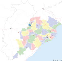
Orissa locator map |
||
| Description |
Locator map for the Indian state of w:Orissa. Equirectangular projection - Geographic limits of the map: top=24.27, bottom=17.691 |
||
| நாள் | |||
| மூலம் |
சொந்த முயற்சி |
||
| படைப்பாளி |
|
||
| அனுமதி (இக்கோப்பை மீண்டும் பயன்படுத்துதல்) |
இந்த ஆக்கத்தின் காப்புரிமையாளரான நான் இதனைப் பின்வரும் உரிமத்தின் கீழ் வெளியிடுகின்றேன்: இந்த கோப்பு Creative Commons Attribution-Share Alike 3.0 Unported உரிமத்தின் கீழ் உள்ளது.
|
||
| Geotemporal data | |||
| Date depicted | second half of 20 century உம் 21 century | ||
| Georeferencing | If inappropriate please set warp_status = skip to hide. | ||
| Archival data | |||
| குறிப்புகள் | Part of WikiProject India Maps | ||
கோப்பின் வரலாறு
குறித்த நேரத்தில் இருந்த படிமத்தைப் பார்க்க அந்நேரத்தின் மீது சொடுக்கவும்.
| நாள்/நேரம் | நகம் அளவு சிறுபடம் | அளவுகள் | பயனர் | கருத்து | |
|---|---|---|---|---|---|
| தற்போதைய | 17:28, 6 செப்டெம்பர் 2008 | | 2,269 × 2,241 (211 KB) | Planemad | |
| 13:28, 21 பெப்பிரவரி 2008 |  | 647 × 564 (132 KB) | Mkeranat~commonswiki | {{Information |Description=Locator map for the state of [w:Orissa] updated to show white borders for districts |Source=self-made, based on India locator map by [w:User:Planemad] |Date=Feb 2008 |Author= Mkeranat |Permission= |other_versions= }} | |
| 21:32, 14 பெப்பிரவரி 2008 |  | 647 × 564 (130 KB) | Mkeranat~commonswiki | {{Information |Description=Locator map for the state of [w:Orissa] |Source=self-made, based on India locator map by [w:User:Planemad] |Date=Feb 2008 |Author= Mkeranat |Permission= |other_versions= }} |
கோப்பு பயன்பாடு
பின்வரும் 5 பக்கங்கள் இணைப்பு இப் படிமத்துக்கு இணைக்கபட்டுள்ளது(ளன):
கோப்பின் முழுமையான பயன்பாடு
கீழ்கண்ட மற்ற விக்கிகள் இந்த கோப்பை பயன்படுத்துகின்றன:
- ar.wikipedia.org-திட்டத்தில் இதன் பயன்பாடு
- as.wikipedia.org-திட்டத்தில் இதன் பயன்பாடு
- awa.wikipedia.org-திட்டத்தில் இதன் பயன்பாடு
- ba.wikipedia.org-திட்டத்தில் இதன் பயன்பாடு
- ceb.wikipedia.org-திட்டத்தில் இதன் பயன்பாடு
- de.wikipedia.org-திட்டத்தில் இதன் பயன்பாடு
- en.wikipedia.org-திட்டத்தில் இதன் பயன்பாடு
- es.wikipedia.org-திட்டத்தில் இதன் பயன்பாடு
- fa.wikipedia.org-திட்டத்தில் இதன் பயன்பாடு
- gu.wikipedia.org-திட்டத்தில் இதன் பயன்பாடு
- hi.wikipedia.org-திட்டத்தில் இதன் பயன்பாடு
- नलबण पक्षी अभयारण्य
- साँचा:ओड़िशा के लोकसभा निर्वाचन क्षेत्र
- आस्का लोक सभा निर्वाचन क्षेत्र
- भुवनेश्वर लोक सभा निर्वाचन क्षेत्र
- बलांगिर लोक सभा निर्वाचन क्षेत्र
- कटक लोक सभा निर्वाचन क्षेत्र
- ढेंकानाल लोक सभा निर्वाचन क्षेत्र
- जगतसिंहपुर लोक सभा निर्वाचन क्षेत्र
- जाजपुर लोक सभा निर्वाचन क्षेत्र
- कलाहांडी लोक सभा निर्वाचन क्षेत्र
- कंधमाल लोक सभा निर्वाचन क्षेत्र
சிறப்பு பக்கம்-மொத்த பயன்பாடு - இதன் மூலம் இந்த கோப்பின் மொத்த பயன்பாட்டை அறிய முடியும்