படிமம்:Orbits around earth scale diagram.svg

Size of this PNG preview of this SVG file: 600 × 600 படப்புள்ளிகள். மற்ற பிரிதிறன்கள்: 240 × 240 படப்புள்ளிகள் | 480 × 480 படப்புள்ளிகள் | 768 × 768 படப்புள்ளிகள் | 1,024 × 1,024 படப்புள்ளிகள் | 2,048 × 2,048 படப்புள்ளிகள் | 4,300 × 4,300 படப்புள்ளிகள் .
மூலக்கோப்பு (SVG கோப்பு, பெயரளவில் 4,300 × 4,300 பிக்சல்கள், கோப்பு அளவு: 5 KB)
| இது விக்கிமீடியா பொதுக்கோப்பகத்தில் இருக்கும் ஒரு கோப்பாகும். இக்கோப்பைக் குறித்து அங்கே காணப்படும் படிம விளக்கப் பக்கத்தை இங்கே கீழே காணலாம்.
|
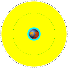
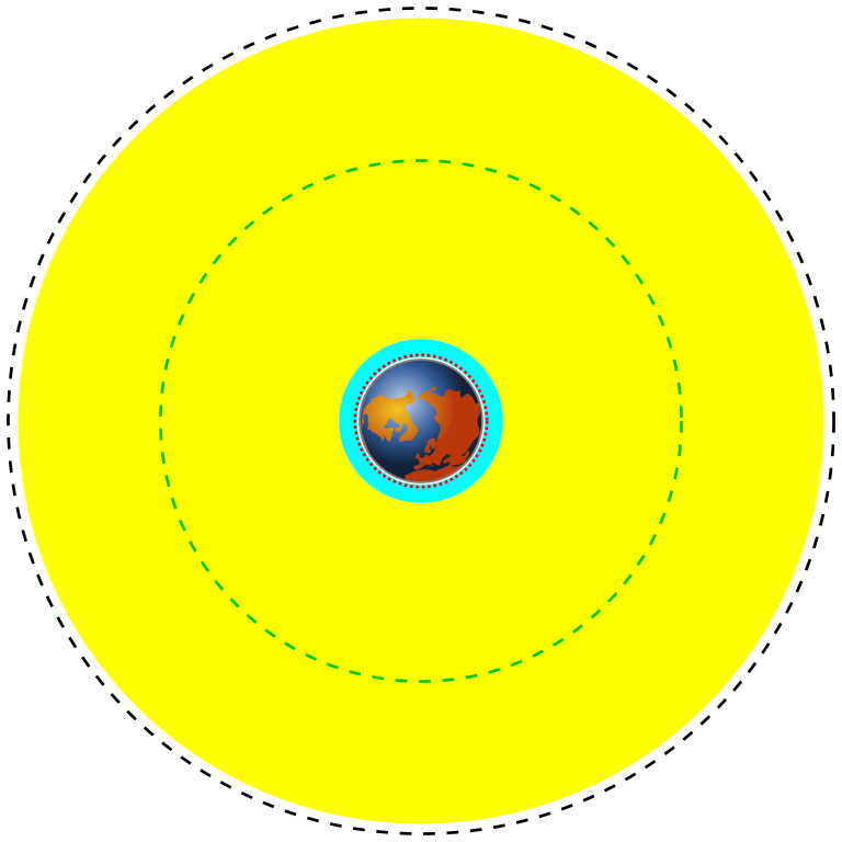
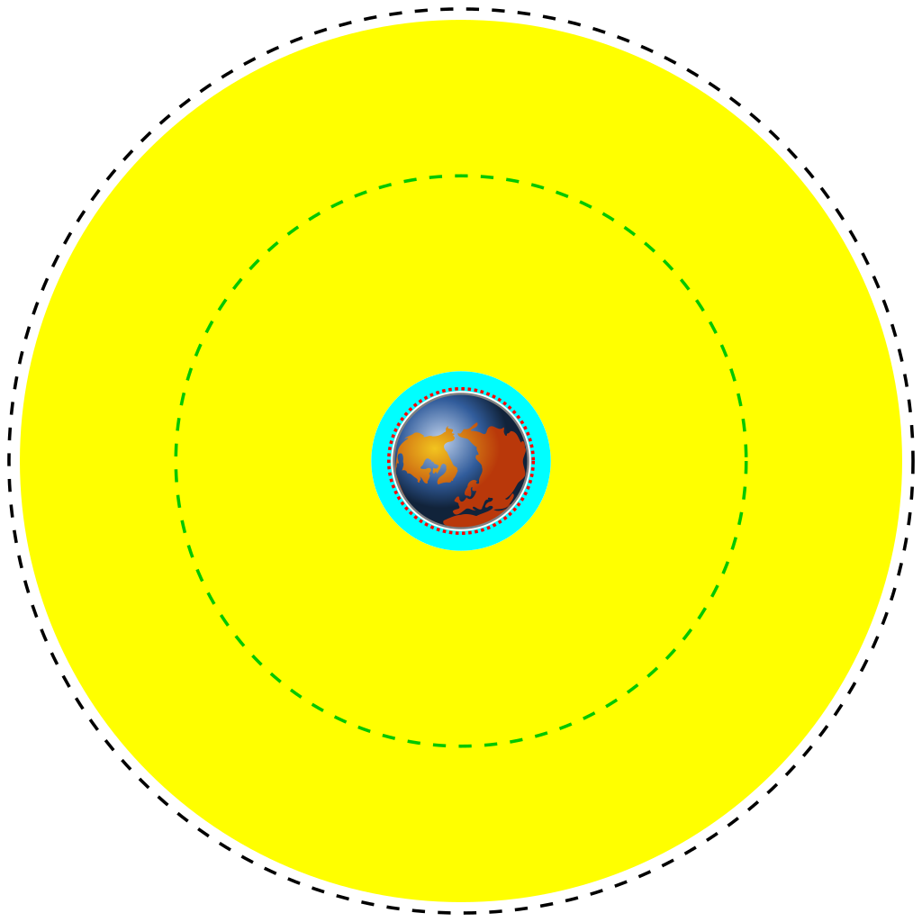
| English | Deutsch | Français | Marker | Distance above earth (km) | Distance from center of earth (km) |
|---|---|---|---|---|---|
| Earth | Erde | Terre | Blue/brown image | 0 | 6370 |
| Low Earth Orbit (LEO) | Low Earth Orbit | Orbite terrestre basse | Cyan area | 160 to 2,000 | 6,530 to 8,370 |
| Medium Earth Orbit (MEO) | Medium Earth Orbit | Orbite moyenne de la terre | Yellow area | 2,000 to 34,780 | 8,370 to 41,150 |
| International Space Station (ISS) | Internationale Raumstation | Station spatiale internationale | Red dotted line | 370 | 6,741 |
| Global Positioning System (GPS) satellites | Globales Positionsbestimmungssystem | Système de positionnement mondial | Green dash-dot line | 20,230 | 26,600 |
| Geostationary Orbit (GEO) | Geostationäre Umlaufbahn | Orbite géostationnaire | Black dashed line | 35,794 | 42,164 |
| விளக்கம் |
English: A scale diagram showing earth and various orbits above it.
Deutsch: Skalendiagramm der Erde und verschiedener Umlaufbahnen.
Français : Diagramme échelle montrant la terre et des orbites. |
||
| நாள் | |||
| மூலம் | Created by Commons user Mike1024, Earth based on File:Worldmap northern.svg | ||
| ஆசிரியர் | Image of earth: Gringer. Scale orbits: Mike1024 | ||
| அனுமதி (இக்கோப்பை மீண்டும் பயன்படுத்துதல்) |
This image is based on a public domain image (File:Worldmap northern.svg) and is released into the public domain.
|
12121
கோப்பின் வரலாறு
குறித்த நேரத்தில் இருந்த படிமத்தைப் பார்க்க அந்நேரத்தின் மீது சொடுக்கவும்.
| நாள்/நேரம் | நகம் அளவு சிறுபடம் | அளவுகள் | பயனர் | கருத்து | |
|---|---|---|---|---|---|
| தற்போதைய | 19:06, 30 மார்ச்சு 2014 | | 4,300 × 4,300 (5 KB) | XZise | fixed rotation of Earth (is now looking from above) |
| 15:27, 30 மார்ச்சு 2014 |  | 4,300 × 4,300 (3 KB) | XZise | manually rewritten from scratch thus dramatically reduced file size | |
| 23:19, 16 சனவரி 2008 |  | 3,009 × 3,009 (19 KB) | Mike1024 | {| class="wikitable" style="text-align:center" |- ! English !! Deutsch !! Français !! Marker !! Distance above earth (km) |!!Distance from center of earth (km) |- ! Earth !! Erde !! Terre | Blue/brown image || 0 | |
கோப்பு பயன்பாடு
பின்வரும் 3 பக்கங்கள் இணைப்பு இப் படிமத்துக்கு இணைக்கபட்டுள்ளது(ளன):
கோப்பின் முழுமையான பயன்பாடு
கீழ்கண்ட மற்ற விக்கிகள் இந்த கோப்பை பயன்படுத்துகின்றன:
- ar.wikipedia.org-திட்டத்தில் இதன் பயன்பாடு
- ast.wikipedia.org-திட்டத்தில் இதன் பயன்பாடு
- bn.wikipedia.org-திட்டத்தில் இதன் பயன்பாடு
- ca.wikipedia.org-திட்டத்தில் இதன் பயன்பாடு
- cs.wikipedia.org-திட்டத்தில் இதன் பயன்பாடு
- da.wikipedia.org-திட்டத்தில் இதன் பயன்பாடு
- de.wikipedia.org-திட்டத்தில் இதன் பயன்பாடு
- el.wikipedia.org-திட்டத்தில் இதன் பயன்பாடு
- en.wikipedia.org-திட்டத்தில் இதன் பயன்பாடு
- en.wikiversity.org-திட்டத்தில் இதன் பயன்பாடு
- eo.wikipedia.org-திட்டத்தில் இதன் பயன்பாடு
- es.wikipedia.org-திட்டத்தில் இதன் பயன்பாடு
- et.wikipedia.org-திட்டத்தில் இதன் பயன்பாடு
- eu.wikipedia.org-திட்டத்தில் இதன் பயன்பாடு
- fa.wikipedia.org-திட்டத்தில் இதன் பயன்பாடு
- fi.wikipedia.org-திட்டத்தில் இதன் பயன்பாடு
- fr.wikipedia.org-திட்டத்தில் இதன் பயன்பாடு
- gu.wikipedia.org-திட்டத்தில் இதன் பயன்பாடு
- he.wikipedia.org-திட்டத்தில் இதன் பயன்பாடு
- hi.wikipedia.org-திட்டத்தில் இதன் பயன்பாடு
- hr.wikipedia.org-திட்டத்தில் இதன் பயன்பாடு
சிறப்பு பக்கம்-மொத்த பயன்பாடு - இதன் மூலம் இந்த கோப்பின் மொத்த பயன்பாட்டை அறிய முடியும்