படிமம்:Rothney Castle Shimla.jpg
மூலக்கோப்பு (7,590 × 6,160 படவணுக்கள், கோப்பின் அளவு: 19.32 MB, MIME வகை: image/jpeg)
| இது விக்கிமீடியா பொதுக்கோப்பகத்தில் இருக்கும் ஒரு கோப்பாகும். இக்கோப்பைக் குறித்து அங்கே காணப்படும் படிம விளக்கப் பக்கத்தை இங்கே கீழே காணலாம்.
|
| Description |
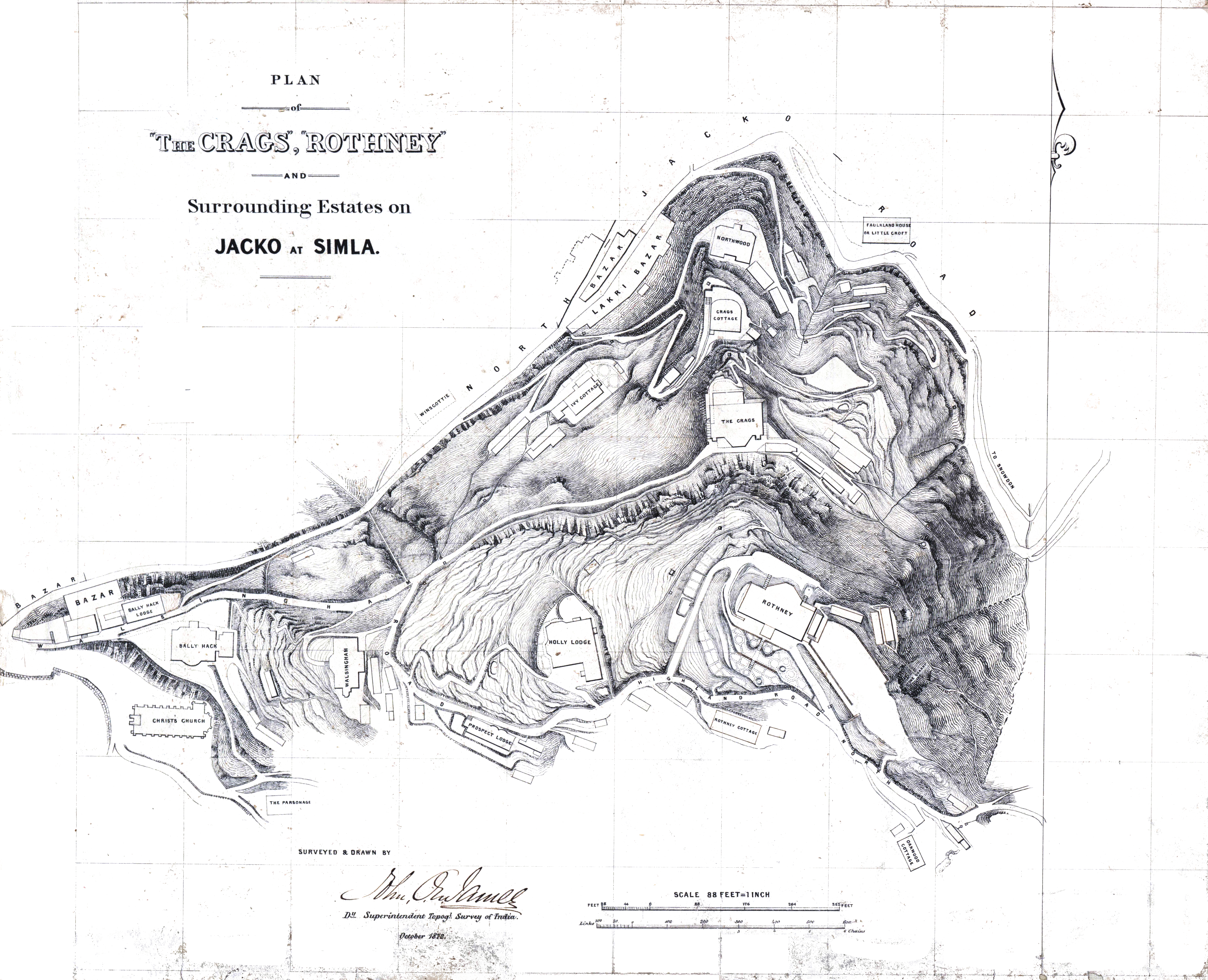
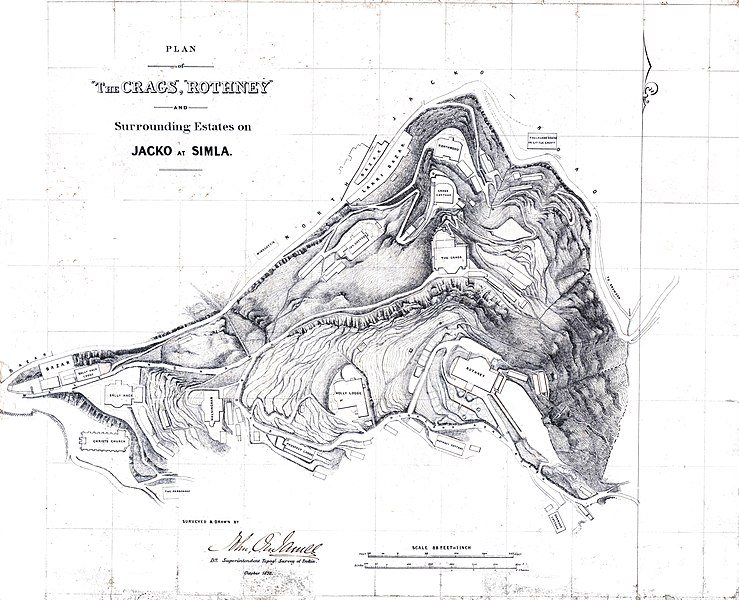
Simla - Plan of the "Crags", "Rothney" and surrounding estates on Jacko at Simla. Scale 1" to 8 feet. Surveyed and drawn by J.O.N. James. 1872. MS. F.10/7 |
|||||||||
| நாள் | ||||||||||
| மூலம் | National Archives of India. Historical Maps. Folio No 10. Sheet 7.- originally by Topographical Survey of India, John James | |||||||||
| படைப்பாளி |
John James, Deputy Superintendent, Topographical Survey of India |
|||||||||
| அனுமதி (இக்கோப்பை மீண்டும் பயன்படுத்துதல்) |
|
|||||||||
| Geotemporal data | ||||||||||
| Bounding box |
|
|||||||||
| Georeferencing | ||||||||||
கோப்பின் வரலாறு
குறித்த நேரத்தில் இருந்த படிமத்தைப் பார்க்க அந்நேரத்தின் மீது சொடுக்கவும்.
| நாள்/நேரம் | நகம் அளவு சிறுபடம் | அளவுகள் | பயனர் | கருத்து | |
|---|---|---|---|---|---|
| தற்போதைய | 08:19, 27 மார்ச்சு 2021 | | 7,590 × 6,160 (19.32 MB) | Shyamal | better image |
| 15:49, 11 ஆகத்து 2015 |  | 2,196 × 1,880 (1.47 MB) | Shyamal | {{Information |Description=Rothney Castle in Shimla, survey map |Source=National Archives of India. Historical Maps. Folio No 10. Sheet 7.- originally by Topographical Survey of India, John James |Date=1872 |Author=John James, Deputy Superintendent, To... |
கோப்பு பயன்பாடு
பின்வரும் பக்க இணைப்புகள் இப் படிமத்துக்கு இணைக்கபட்டுள்ளது(ளன):
கோப்பின் முழுமையான பயன்பாடு
கீழ்கண்ட மற்ற விக்கிகள் இந்த கோப்பை பயன்படுத்துகின்றன:
- en.wikipedia.org-திட்டத்தில் இதன் பயன்பாடு
- pt.wikipedia.org-திட்டத்தில் இதன் பயன்பாடு