படிமம்:SevenYearsWar.png

இந்த முன்னோட்டத்தின் அளவு: 800 × 370 படப்புள்ளிகள் . மற்ற பிரிதிறன்கள்: 320 × 148 படப்புள்ளிகள் | 640 × 296 படப்புள்ளிகள் | 1,357 × 628 படப்புள்ளிகள் .
மூலக்கோப்பு (1,357 × 628 படவணுக்கள், கோப்பின் அளவு: 41 KB, MIME வகை: image/png)
| இது விக்கிமீடியா பொதுக்கோப்பகத்தில் இருக்கும் ஒரு கோப்பாகும். இக்கோப்பைக் குறித்து அங்கே காணப்படும் படிம விளக்கப் பக்கத்தை இங்கே கீழே காணலாம்.
|

|
This military map image could be re-created using vector graphics as an SVG file. This has several advantages; see Commons:Media for cleanup for more information. If an SVG form of this image is available, please upload it and afterwards replace this template with
{{vector version available|new image name}}.
It is recommended to name the SVG file “SevenYearsWar.svg”—then the template Vector version available (or Vva) does not need the new image name parameter. |
சுருக்கம்
| விளக்கம் |
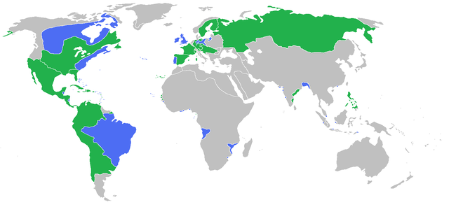
English: Locator map of the competing sides of the Seven Years War before outset of the war (mid-1750s). Blue: Great Britain, Portugal with more. Green: France, Spain with more. Great Britain, Prussia, Portugal, with allies
France, Spain, Austria, Russia, Sweden with allies Français : Carte montrant les forces en présence lors de la guerre de Sept Ans (milieu des années 1750).
Grande Bretagne, Prusse, Portugal, leurs alliés et dépendances
France, Espagne, Autriche, Russie, Suède, leurs alliés et dépendances (Partially based on Atlas of World History (2007) - There was also a treaty in 1783, Imperialism and Revolutions, map) |
| நாள் | |
| மூலம் | சொந்த முயற்சி |
| ஆசிரியர் | Gabagool |
அனுமதி
இந்த ஆக்கத்தின் காப்புரிமையாளரான நான் இதனைப் பின்வரும் உரிமத்தின் கீழ் வெளியிடுகின்றேன்:
This file is licensed under the Creative Commons Attribution 3.0 Unported license.
- நீங்கள் சுதந்திரமாக:
- பகிர்ந்து கொள்ள – வேலையை நகலெடுக்க, விநியோகிக்க மற்றும் அனுப்ப
- மீண்டும் கலக்க – வேலைக்கு பழகிக்கொள்ள.
- கீழ்க்காணும் விதிகளுக்கு ஏற்ப,
- பண்புக்கூறுகள் – நீங்கள் பொருத்தமான உரிமையை வழங்க வேண்டும், உரிமத்திற்கான இணைப்பை வழங்க வேண்டும் மற்றும் மாற்றங்கள் செய்யப்பட்டிருந்தால் குறிப்பிட வேண்டும். நீங்கள் ஏற்புடைய எந்த முறையிலும் அவ்வாறு செய்யலாம், ஆனால் எந்த வகையிலும் உரிமதாரர் உங்களை அல்லது உங்கள் பயன்பாட்டிற்கு ஒப்புதல் அளிக்கும் படி பரிந்துரைக்க கூடாது.
கோப்பின் வரலாறு
குறித்த நேரத்தில் இருந்த படிமத்தைப் பார்க்க அந்நேரத்தின் மீது சொடுக்கவும்.
| நாள்/நேரம் | நகம் அளவு சிறுபடம் | அளவுகள் | பயனர் | கருத்து | |
|---|---|---|---|---|---|
| தற்போதைய | 15:54, 23 சூன் 2009 | | 1,357 × 628 (41 KB) | Gabagool | corrected India more appropriatly |
| 13:59, 11 சூன் 2009 |  | 1,357 × 628 (41 KB) | Gabagool | some fixes | |
| 11:16, 11 சூன் 2009 |  | 1,357 × 628 (41 KB) | Gabagool | more details in Germany | |
| 22:20, 6 சூன் 2009 |  | 1,357 × 628 (41 KB) | Gabagool | {{Information |Description={{en|1=Locator map of the competing sides of the Seven Years War before outset of the war (early 1750s).<br> Blue: Great Britain, Portugal with more. Green: France, Spain with more. Light green: French largest expansion in India |
கோப்பு பயன்பாடு
பின்வரும் பக்க இணைப்புகள் இப் படிமத்துக்கு இணைக்கபட்டுள்ளது(ளன):
கோப்பின் முழுமையான பயன்பாடு
கீழ்கண்ட மற்ற விக்கிகள் இந்த கோப்பை பயன்படுத்துகின்றன:
- af.wikipedia.org-திட்டத்தில் இதன் பயன்பாடு
- als.wikipedia.org-திட்டத்தில் இதன் பயன்பாடு
- an.wikipedia.org-திட்டத்தில் இதன் பயன்பாடு
- ar.wikipedia.org-திட்டத்தில் இதன் பயன்பாடு
- arz.wikipedia.org-திட்டத்தில் இதன் பயன்பாடு
- ast.wikipedia.org-திட்டத்தில் இதன் பயன்பாடு
- az.wikipedia.org-திட்டத்தில் இதன் பயன்பாடு
- ba.wikipedia.org-திட்டத்தில் இதன் பயன்பாடு
- bg.wikipedia.org-திட்டத்தில் இதன் பயன்பாடு
- bn.wikipedia.org-திட்டத்தில் இதன் பயன்பாடு
- br.wikipedia.org-திட்டத்தில் இதன் பயன்பாடு
- bs.wikipedia.org-திட்டத்தில் இதன் பயன்பாடு
- ca.wikipedia.org-திட்டத்தில் இதன் பயன்பாடு
- cs.wikipedia.org-திட்டத்தில் இதன் பயன்பாடு
- da.wikipedia.org-திட்டத்தில் இதன் பயன்பாடு
- de.wikipedia.org-திட்டத்தில் இதன் பயன்பாடு
- dsb.wikipedia.org-திட்டத்தில் இதன் பயன்பாடு
- en.wikipedia.org-திட்டத்தில் இதன் பயன்பாடு
- eo.wikipedia.org-திட்டத்தில் இதன் பயன்பாடு
- es.wikipedia.org-திட்டத்தில் இதன் பயன்பாடு
- fa.wikipedia.org-திட்டத்தில் இதன் பயன்பாடு
- fi.wikipedia.org-திட்டத்தில் இதன் பயன்பாடு
- fr.wikipedia.org-திட்டத்தில் இதன் பயன்பாடு
- ga.wikipedia.org-திட்டத்தில் இதன் பயன்பாடு
- he.wikipedia.org-திட்டத்தில் இதன் பயன்பாடு
- hi.wikipedia.org-திட்டத்தில் இதன் பயன்பாடு
- hsb.wikipedia.org-திட்டத்தில் இதன் பயன்பாடு
- is.wikipedia.org-திட்டத்தில் இதன் பயன்பாடு
- it.wikipedia.org-திட்டத்தில் இதன் பயன்பாடு
- ja.wikipedia.org-திட்டத்தில் இதன் பயன்பாடு
- ko.wikipedia.org-திட்டத்தில் இதன் பயன்பாடு
- lt.wikipedia.org-திட்டத்தில் இதன் பயன்பாடு
- lv.wikipedia.org-திட்டத்தில் இதன் பயன்பாடு
சிறப்பு பக்கம்-மொத்த பயன்பாடு - இதன் மூலம் இந்த கோப்பின் மொத்த பயன்பாட்டை அறிய முடியும்