படிமம்:Sint Maarten-CIA WFB Map.png
இதைவிட அளவில் பெரிய படிமம் இல்லை.
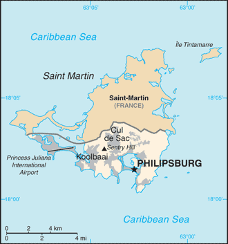
Sint_Maarten-CIA_WFB_Map.png (330 × 353 படவணுக்கள், கோப்பின் அளவு: 14 KB, MIME வகை: image/png)
| இது விக்கிமீடியா பொதுக்கோப்பகத்தில் இருக்கும் ஒரு கோப்பாகும். இக்கோப்பைக் குறித்து அங்கே காணப்படும் படிம விளக்கப் பக்கத்தை இங்கே கீழே காணலாம்.
|

|
This locator map image could be re-created using vector graphics as an SVG file. This has several advantages; see Commons:Media for cleanup for more information. If an SVG form of this image is available, please upload it and afterwards replace this template with
{{vector version available|new image name}}.
It is recommended to name the SVG file “Sint Maarten-CIA WFB Map.svg”—then the template Vector version available (or Vva) does not need the new image name parameter. |
| விளக்கம் | Map of Sint Maarten from the 2010-10-22 revision of the World Factbook |
| நாள் | |
| மூலம் | World Factbook website |
| ஆசிரியர் | Directorate of Intelligence, CIA |
இந்தப்படிமம் அல்லது வரைப்படம் ஐக்கிய அமெரிக்காவின் நடுவப் புலனாய்வு நிறுவனத்தினால்(CIA) வெளியிடப்படும் உலக உணமைகள் நூலில்(World Factbook) இருந்து நேரடியாக அல்லது மாற்றங்களுடன் எடுக்கப்பட்டதாகும். ஐக்கிய அமெரிக்காவின் சட்டத்தின் படி உலக உணமைகள் நூலின் உள்ளடக்கங்கள் யாவும் பொது உரிமையாகும்.
|
 |
கோப்பின் வரலாறு
குறித்த நேரத்தில் இருந்த படிமத்தைப் பார்க்க அந்நேரத்தின் மீது சொடுக்கவும்.
| நாள்/நேரம் | நகம் அளவு சிறுபடம் | அளவுகள் | பயனர் | கருத்து | |
|---|---|---|---|---|---|
| தற்போதைய | 11:32, 23 அக்டோபர் 2010 | | 330 × 353 (14 KB) | Hoshie | {{Information |Description= Map of {{w|Sint Maarten}} from the 2010-10-22 revision of the World Factbook |Source= [https://www.cia.gov/library/publications/the-world-factbook/maps/maptemplate_sk.html World Factbook website] |Date= 2010-10-22 |Author= Dire |
கோப்பு பயன்பாடு
பின்வரும் பக்க இணைப்புகள் இப் படிமத்துக்கு இணைக்கபட்டுள்ளது(ளன):
கோப்பின் முழுமையான பயன்பாடு
கீழ்கண்ட மற்ற விக்கிகள் இந்த கோப்பை பயன்படுத்துகின்றன:
- af.wikipedia.org-திட்டத்தில் இதன் பயன்பாடு
- bn.wikipedia.org-திட்டத்தில் இதன் பயன்பாடு
- ceb.wikipedia.org-திட்டத்தில் இதன் பயன்பாடு
- el.wikipedia.org-திட்டத்தில் இதன் பயன்பாடு
- en.wikipedia.org-திட்டத்தில் இதன் பயன்பாடு
- fa.wikipedia.org-திட்டத்தில் இதன் பயன்பாடு
- fr.wikipedia.org-திட்டத்தில் இதன் பயன்பாடு
- gcr.wikipedia.org-திட்டத்தில் இதன் பயன்பாடு
- gom.wikipedia.org-திட்டத்தில் இதன் பயன்பாடு
- hi.wikipedia.org-திட்டத்தில் இதன் பயன்பாடு
- hu.wikipedia.org-திட்டத்தில் இதன் பயன்பாடு
- ia.wikipedia.org-திட்டத்தில் இதன் பயன்பாடு
- id.wikipedia.org-திட்டத்தில் இதன் பயன்பாடு
- incubator.wikimedia.org-திட்டத்தில் இதன் பயன்பாடு
- it.wikipedia.org-திட்டத்தில் இதன் பயன்பாடு
- ja.wikipedia.org-திட்டத்தில் இதன் பயன்பாடு
- lad.wikipedia.org-திட்டத்தில் இதன் பயன்பாடு
- lb.wikipedia.org-திட்டத்தில் இதன் பயன்பாடு
- mk.wikipedia.org-திட்டத்தில் இதன் பயன்பாடு
- ml.wikipedia.org-திட்டத்தில் இதன் பயன்பாடு
- nl.wikipedia.org-திட்டத்தில் இதன் பயன்பாடு
- pa.wikipedia.org-திட்டத்தில் இதன் பயன்பாடு
- pl.wikipedia.org-திட்டத்தில் இதன் பயன்பாடு
- ru.wikipedia.org-திட்டத்தில் இதன் பயன்பாடு
- sc.wikipedia.org-திட்டத்தில் இதன் பயன்பாடு
- shn.wikipedia.org-திட்டத்தில் இதன் பயன்பாடு
- simple.wikipedia.org-திட்டத்தில் இதன் பயன்பாடு
- su.wikipedia.org-திட்டத்தில் இதன் பயன்பாடு
- to.wikipedia.org-திட்டத்தில் இதன் பயன்பாடு
- tr.wikipedia.org-திட்டத்தில் இதன் பயன்பாடு
- tt.wikipedia.org-திட்டத்தில் இதன் பயன்பாடு
- uk.wikipedia.org-திட்டத்தில் இதன் பயன்பாடு
- ur.wikipedia.org-திட்டத்தில் இதன் பயன்பாடு
- vec.wikipedia.org-திட்டத்தில் இதன் பயன்பாடு
- www.wikidata.org-திட்டத்தில் இதன் பயன்பாடு
- zh-yue.wikipedia.org-திட்டத்தில் இதன் பயன்பாடு
- zh.wikipedia.org-திட்டத்தில் இதன் பயன்பாடு