படிமம்:South Indian territories.svg

Size of this PNG preview of this SVG file: 540 × 599 படப்புள்ளிகள். மற்ற பிரிதிறன்கள்: 216 × 240 படப்புள்ளிகள் | 432 × 480 படப்புள்ளிகள் | 692 × 768 படப்புள்ளிகள் | 922 × 1,024 படப்புள்ளிகள் | 1,845 × 2,048 படப்புள்ளிகள் | 672 × 746 படப்புள்ளிகள் .
மூலக்கோப்பு (SVG கோப்பு, பெயரளவில் 672 × 746 பிக்சல்கள், கோப்பு அளவு: 306 KB)
| இது விக்கிமீடியா பொதுக்கோப்பகத்தில் இருக்கும் ஒரு கோப்பாகும். இக்கோப்பைக் குறித்து அங்கே காணப்படும் படிம விளக்கப் பக்கத்தை இங்கே கீழே காணலாம்.
|
சுருக்கம்
| விளக்கம் | |
| நாள் |
7 சனவரி 2008 (original upload date) |
| மூலம் |
Own work based on: Hyderabad state 1909.jpg, Bombay Prov south 1909.jpg and Plate 34. Sect. XIII- Madras, Mysore and Goa maps from Constable 1893 Hand Atlas.jpg
|
| ஆசிரியர் | AreJay |
| அனுமதி (இக்கோப்பை மீண்டும் பயன்படுத்துதல்) |
GFDL, CC-Attrib |
| ஒத்தக்கோப்பு |
Derivative works of this file: |
அனுமதி
இந்த ஆக்கத்தின் காப்புரிமையாளரான AreJay at ஆங்கிலம் விக்கிப்பீடியா எனும் நான் இதனைப் பின்வரும் உரிமத்தின் கீழ் வெளியிடுகின்றேன்:

|
GNU Free Documentation License விதிமுறைகளின் கீழ் இந்த ஆவணத்தை நகலெடுக்க, விநியோகிக்க மற்றும்/அல்லது மாற்றுவதற்கு அனுமதி வழங்கப்பட்டுள்ளது, Free Software Foundation;ஆல் வெளியிடப்பட்ட பதிப்பு 1.2 அல்லது அதற்குப் பிந்தைய பதிப்பு, மாற்றமில்லாத பிரிவுகள், முன் அட்டை உரைகள் மற்றும் பின் அட்டை உரைகள் இல்லாமல் வெளியிடப்பட்டது. GNU Free Documentation License என்ற தலைப்பில் உரிமத்தின் நகல் சேர்க்கப்பட்டுள்ளது. |
This file is licensed under the Creative Commons Attribution 3.0 Unported license.
பண்புக்கூறுகள்: AreJay at ஆங்கிலம் விக்கிப்பீடியா
- நீங்கள் சுதந்திரமாக:
- பகிர்ந்து கொள்ள – வேலையை நகலெடுக்க, விநியோகிக்க மற்றும் அனுப்ப
- மீண்டும் கலக்க – வேலைக்கு பழகிக்கொள்ள.
- கீழ்க்காணும் விதிகளுக்கு ஏற்ப,
- பண்புக்கூறுகள் – நீங்கள் பொருத்தமான உரிமையை வழங்க வேண்டும், உரிமத்திற்கான இணைப்பை வழங்க வேண்டும் மற்றும் மாற்றங்கள் செய்யப்பட்டிருந்தால் குறிப்பிட வேண்டும். நீங்கள் ஏற்புடைய எந்த முறையிலும் அவ்வாறு செய்யலாம், ஆனால் எந்த வகையிலும் உரிமதாரர் உங்களை அல்லது உங்கள் பயன்பாட்டிற்கு ஒப்புதல் அளிக்கும் படி பரிந்துரைக்க கூடாது.
நீர் உமக்கு விருப்பமான உரிமத்தை தேர்ந்தெடுக்கலாம்.
Original upload log
Transferred from en.wikipedia to Commons by Kelly using CommonsHelper.
The original description page was here. All following user names refer to en.wikipedia.
- 2008-04-11 04:19 AreJay 693×748×0 (724956 bytes) '
- 2008-01-09 03:46 AreJay 693×747×0 (599498 bytes) '
- 2008-01-09 03:45 AreJay 693×747×0 (600270 bytes) '
- 2008-01-09 03:43 AreJay 693×747×0 (600126 bytes) '
- 2008-01-09 03:36 AreJay 693×747×0 (600077 bytes) '
- 2008-01-09 03:21 AreJay 693×801×0 (603408 bytes) changes
- 2008-01-08 01:02 AreJay 690×726×0 (615193 bytes) cleanup
- 2008-01-07 18:22 AreJay 690×726×0 (615142 bytes) corrected spelling error
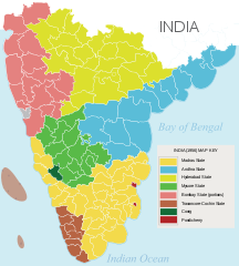
- 2008-01-07 02:35 AreJay 690×726×0 (615141 bytes) {{Information |Description= [[South India]]n states prior to the ''[[States Reorganisation Act]]'' (1956) |Source=self-made |Date= Jan 6, 2008 |Location= Atlanta, GA, USA |Author= [[User:AreJay|]] |Permission= GFDL, CC-Attrib |other_versions={{DerivativeVersions|South Indian territories 2009 de.svg}} }}
கோப்பின் வரலாறு
குறித்த நேரத்தில் இருந்த படிமத்தைப் பார்க்க அந்நேரத்தின் மீது சொடுக்கவும்.
| நாள்/நேரம் | நகம் அளவு சிறுபடம் | அளவுகள் | பயனர் | கருத்து | |
|---|---|---|---|---|---|
| தற்போதைய | 23:37, 23 நவம்பர் 2014 | | 672 × 746 (306 KB) | Ras67 | black frame and Illustrator data removed |
| 01:35, 13 சூன் 2008 |  | 693 × 748 (708 KB) | File Upload Bot (Magnus Manske) | {{BotMoveToCommons|en.wikipedia}} {{Information |Description={{en|en:South Indian states prior to the ''en:States Reorganisation Act'' (1956)<br/> == Source data and maps == 1. Nizam's Territories: http://mahbubia.com/images/Map%20of%20Hyderab |
கோப்பு பயன்பாடு
பின்வரும் 5 பக்கங்கள் இணைப்பு இப் படிமத்துக்கு இணைக்கபட்டுள்ளது(ளன):
கோப்பின் முழுமையான பயன்பாடு
கீழ்கண்ட மற்ற விக்கிகள் இந்த கோப்பை பயன்படுத்துகின்றன:
- ar.wikipedia.org-திட்டத்தில் இதன் பயன்பாடு
- bn.wikipedia.org-திட்டத்தில் இதன் பயன்பாடு
- ca.wikipedia.org-திட்டத்தில் இதன் பயன்பாடு
- en.wikipedia.org-திட்டத்தில் இதன் பயன்பாடு
- es.wikipedia.org-திட்டத்தில் இதன் பயன்பாடு
- eu.wikipedia.org-திட்டத்தில் இதன் பயன்பாடு
- fa.wikipedia.org-திட்டத்தில் இதன் பயன்பாடு
- fr.wikipedia.org-திட்டத்தில் இதன் பயன்பாடு
- he.wikipedia.org-திட்டத்தில் இதன் பயன்பாடு
- hi.wikipedia.org-திட்டத்தில் இதன் பயன்பாடு
- id.wikipedia.org-திட்டத்தில் இதன் பயன்பாடு
- kn.wikipedia.org-திட்டத்தில் இதன் பயன்பாடு
- ml.wikipedia.org-திட்டத்தில் இதன் பயன்பாடு
- mr.wikipedia.org-திட்டத்தில் இதன் பயன்பாடு
- ms.wikipedia.org-திட்டத்தில் இதன் பயன்பாடு
- ne.wikipedia.org-திட்டத்தில் இதன் பயன்பாடு
- ru.wikipedia.org-திட்டத்தில் இதன் பயன்பாடு
- te.wikipedia.org-திட்டத்தில் இதன் பயன்பாடு
- tg.wikipedia.org-திட்டத்தில் இதன் பயன்பாடு
- vi.wikipedia.org-திட்டத்தில் இதன் பயன்பாடு
- www.wikidata.org-திட்டத்தில் இதன் பயன்பாடு