படிமம்:Tyrrhenian Sea map.png

இந்த முன்னோட்டத்தின் அளவு: 440 × 600 படப்புள்ளிகள் . மற்ற பிரிதிறன்கள்: 176 × 240 படப்புள்ளிகள் | 496 × 676 படப்புள்ளிகள் .
மூலக்கோப்பு (496 × 676 படவணுக்கள், கோப்பின் அளவு: 127 KB, MIME வகை: image/png)
| இது விக்கிமீடியா பொதுக்கோப்பகத்தில் இருக்கும் ஒரு கோப்பாகும். இக்கோப்பைக் குறித்து அங்கே காணப்படும் படிம விளக்கப் பக்கத்தை இங்கே கீழே காணலாம்.
|
சுருக்கம்
| விளக்கம் |
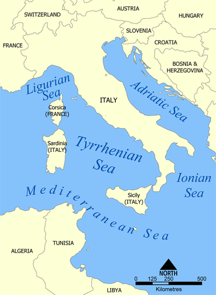
Español: Il Mar Tirreno
A map showing the location of the Tyrrhenian Sea. Created by NormanEinstein, May 19, 2005. |
| நாள் | 19 மே 2005 (original upload date) |
| மூலம் | No machine-readable source provided. Own work assumed (based on copyright claims). |
| ஆசிரியர் | No machine-readable author provided. NormanEinstein assumed (based on copyright claims). |
| ஒத்தக்கோப்பு |
|


அனுமதி
இந்த ஆக்கத்தின் காப்புரிமையாளரான நான் இதனைப் பின்வரும் உரிமத்தின் கீழ் வெளியிடுகின்றேன்:

|
GNU Free Documentation License விதிமுறைகளின் கீழ் இந்த ஆவணத்தை நகலெடுக்க, விநியோகிக்க மற்றும்/அல்லது மாற்றுவதற்கு அனுமதி வழங்கப்பட்டுள்ளது, Free Software Foundation;ஆல் வெளியிடப்பட்ட பதிப்பு 1.2 அல்லது அதற்குப் பிந்தைய பதிப்பு, மாற்றமில்லாத பிரிவுகள், முன் அட்டை உரைகள் மற்றும் பின் அட்டை உரைகள் இல்லாமல் வெளியிடப்பட்டது. GNU Free Documentation License என்ற தலைப்பில் உரிமத்தின் நகல் சேர்க்கப்பட்டுள்ளது. |
| இந்த கோப்பு Creative Commons Attribution-Share Alike 3.0 Unported உரிமத்தின் கீழ் உள்ளது. | ||
| ||
| This licensing tag was added to this file as part of the GFDL licensing update. |
நீர் உமக்கு விருப்பமான உரிமத்தை தேர்ந்தெடுக்கலாம்.

|
This map image could be re-created using vector graphics as an SVG file. This has several advantages; see Commons:Media for cleanup for more information. If an SVG form of this image is available, please upload it and afterwards replace this template with
{{vector version available|new image name}}.
It is recommended to name the SVG file “Tyrrhenian Sea map.svg”—then the template Vector version available (or Vva) does not need the new image name parameter. |
derivative works
Derivative works of this file: Tyrrhenian Sea map ku.png Derivative works of this file: Tyrrhenian Sea map hr.svg
கோப்பின் வரலாறு
குறித்த நேரத்தில் இருந்த படிமத்தைப் பார்க்க அந்நேரத்தின் மீது சொடுக்கவும்.
| நாள்/நேரம் | நகம் அளவு சிறுபடம் | அளவுகள் | பயனர் | கருத்து | |
|---|---|---|---|---|---|
| தற்போதைய | 20:25, 27 பெப்பிரவரி 2012 | | 496 × 676 (127 KB) | Ras67 | cropped, opt |
| 20:23, 19 மே 2005 |  | 500 × 680 (190 KB) | NormanEinstein | A map showing the location of the Tyrrhenian Sea. Created by NormanEinstein, May 19, 2005. {{PD-self}} |
கோப்பு பயன்பாடு
பின்வரும் பக்க இணைப்புகள் இப் படிமத்துக்கு இணைக்கபட்டுள்ளது(ளன):
கோப்பின் முழுமையான பயன்பாடு
கீழ்கண்ட மற்ற விக்கிகள் இந்த கோப்பை பயன்படுத்துகின்றன:
- af.wikipedia.org-திட்டத்தில் இதன் பயன்பாடு
- ary.wikipedia.org-திட்டத்தில் இதன் பயன்பாடு
- azb.wikipedia.org-திட்டத்தில் இதன் பயன்பாடு
- ba.wikipedia.org-திட்டத்தில் இதன் பயன்பாடு
- be-tarask.wikipedia.org-திட்டத்தில் இதன் பயன்பாடு
- be.wikipedia.org-திட்டத்தில் இதன் பயன்பாடு
- bh.wikipedia.org-திட்டத்தில் இதன் பயன்பாடு
- bn.wikipedia.org-திட்டத்தில் இதன் பயன்பாடு
- bs.wikipedia.org-திட்டத்தில் இதன் பயன்பாடு
- da.wikipedia.org-திட்டத்தில் இதன் பயன்பாடு
- de.wikipedia.org-திட்டத்தில் இதன் பயன்பாடு
- de.wiktionary.org-திட்டத்தில் இதன் பயன்பாடு
- dsb.wikipedia.org-திட்டத்தில் இதன் பயன்பாடு
- el.wikipedia.org-திட்டத்தில் இதன் பயன்பாடு
- en.wikipedia.org-திட்டத்தில் இதன் பயன்பாடு
- en.wikiversity.org-திட்டத்தில் இதன் பயன்பாடு
- en.wiktionary.org-திட்டத்தில் இதன் பயன்பாடு
- eo.wikipedia.org-திட்டத்தில் இதன் பயன்பாடு
- es.wikipedia.org-திட்டத்தில் இதன் பயன்பாடு
- es.wiktionary.org-திட்டத்தில் இதன் பயன்பாடு
- fa.wikipedia.org-திட்டத்தில் இதன் பயன்பாடு
- fi.wikipedia.org-திட்டத்தில் இதன் பயன்பாடு
- gl.wikipedia.org-திட்டத்தில் இதன் பயன்பாடு
- hsb.wikipedia.org-திட்டத்தில் இதன் பயன்பாடு
- hyw.wikipedia.org-திட்டத்தில் இதன் பயன்பாடு
- id.wikipedia.org-திட்டத்தில் இதன் பயன்பாடு
- ilo.wikipedia.org-திட்டத்தில் இதன் பயன்பாடு
- is.wikipedia.org-திட்டத்தில் இதன் பயன்பாடு
- ja.wikipedia.org-திட்டத்தில் இதன் பயன்பாடு
- ka.wikipedia.org-திட்டத்தில் இதன் பயன்பாடு
- kk.wikipedia.org-திட்டத்தில் இதன் பயன்பாடு
- ko.wikipedia.org-திட்டத்தில் இதன் பயன்பாடு
- la.wikipedia.org-திட்டத்தில் இதன் பயன்பாடு
- lt.wikipedia.org-திட்டத்தில் இதன் பயன்பாடு
- ml.wikipedia.org-திட்டத்தில் இதன் பயன்பாடு
- mn.wikipedia.org-திட்டத்தில் இதன் பயன்பாடு
- mr.wikipedia.org-திட்டத்தில் இதன் பயன்பாடு
- ms.wikipedia.org-திட்டத்தில் இதன் பயன்பாடு
- nap.wikipedia.org-திட்டத்தில் இதன் பயன்பாடு
- nn.wikipedia.org-திட்டத்தில் இதன் பயன்பாடு
- no.wikipedia.org-திட்டத்தில் இதன் பயன்பாடு
- pl.wiktionary.org-திட்டத்தில் இதன் பயன்பாடு
சிறப்பு பக்கம்-மொத்த பயன்பாடு - இதன் மூலம் இந்த கோப்பின் மொத்த பயன்பாட்டை அறிய முடியும்