படிமம்:US Virgin Islands admin divisions.png
இந்த முன்னோட்டத்தின் அளவு: 800 × 486 படப்புள்ளிகள் . மற்ற பிரிதிறன்கள்: 320 × 194 படப்புள்ளிகள் | 640 × 389 படப்புள்ளிகள் | 1,022 × 621 படப்புள்ளிகள் .
மூலக்கோப்பு (1,022 × 621 படவணுக்கள், கோப்பின் அளவு: 33 KB, MIME வகை: image/png)
| இது விக்கிமீடியா பொதுக்கோப்பகத்தில் இருக்கும் ஒரு கோப்பாகும். இக்கோப்பைக் குறித்து அங்கே காணப்படும் படிம விளக்கப் பக்கத்தை இங்கே கீழே காணலாம்.
|

|
This map has been uploaded by Electionworld from en.wikipedia.org to enable the |
சுருக்கம்
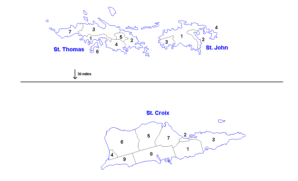
Administrative divisions of the U.S. Virgin Islands. Created by Rarelibra 16:11, 31 March 2006 (UTC) for public domain use. Created using MapInfo Professional v7.5 and vairous mapping resources.
| Districts | Saint Thomas | Saint John | Saint Croix |
|---|---|---|---|
| Sub-districts |
|
|
|
அனுமதி
| I, the copyright holder of this work, release this work into the public domain. This applies worldwide. சில நாடுகளில் இது சாத்தியமில்லாது போகலாம். அவ்வாறாயின் : I grant anyone the right to use this work for any purpose, without any conditions, unless such conditions are required by law. |
கோப்பின் வரலாறு
குறித்த நேரத்தில் இருந்த படிமத்தைப் பார்க்க அந்நேரத்தின் மீது சொடுக்கவும்.
| நாள்/நேரம் | நகம் அளவு சிறுபடம் | அளவுகள் | பயனர் | கருத்து | |
|---|---|---|---|---|---|
| தற்போதைய | 13:57, 19 மார்ச்சு 2014 | | 1,022 × 621 (33 KB) | Ahnoneemoos | removing border |
| 13:55, 19 மார்ச்சு 2014 |  | 1,022 × 621 (33 KB) | Ahnoneemoos | removing border | |
| 20:31, 27 நவம்பர் 2006 |  | 1,025 × 624 (15 KB) | Electionworld | {{ew|en|Rarelibra}} == Summary == Administrative divisions (districts and sub-districts) of the U.S. Virgin Islands. Created by Rarelibra 16:11, 31 March 2006 (UTC) for public domain use. Created using MapInfo Professional v7.5 and |
கோப்பு பயன்பாடு
பின்வரும் பக்க இணைப்புகள் இப் படிமத்துக்கு இணைக்கபட்டுள்ளது(ளன):
கோப்பின் முழுமையான பயன்பாடு
கீழ்கண்ட மற்ற விக்கிகள் இந்த கோப்பை பயன்படுத்துகின்றன:
- ast.wikipedia.org-திட்டத்தில் இதன் பயன்பாடு
- en.wikipedia.org-திட்டத்தில் இதன் பயன்பாடு
- eu.wikipedia.org-திட்டத்தில் இதன் பயன்பாடு
- gl.wikipedia.org-திட்டத்தில் இதன் பயன்பாடு
- li.wikipedia.org-திட்டத்தில் இதன் பயன்பாடு
- mk.wikipedia.org-திட்டத்தில் இதன் பயன்பாடு
- ml.wikipedia.org-திட்டத்தில் இதன் பயன்பாடு
- nn.wikipedia.org-திட்டத்தில் இதன் பயன்பாடு
- no.wikipedia.org-திட்டத்தில் இதன் பயன்பாடு
- os.wikipedia.org-திட்டத்தில் இதன் பயன்பாடு
- sr.wikipedia.org-திட்டத்தில் இதன் பயன்பாடு
- uk.wikipedia.org-திட்டத்தில் இதன் பயன்பாடு
- vi.wikipedia.org-திட்டத்தில் இதன் பயன்பாடு
- www.wikidata.org-திட்டத்தில் இதன் பயன்பாடு