மூலக்கோப்பு (2,953 × 1,704 படவணுக்கள், கோப்பின் அளவு: 997 KB, MIME வகை: image/png)

இது விக்கிமீடியா பொதுக்கோப்பகத்தில் இருக்கும் ஒரு கோப்பாகும். இக்கோப்பைக் குறித்து அங்கே காணப்படும் படிம விளக்கப் பக்கத்தை இங்கே கீழே காணலாம்.
பொதுக்கோப்பகம் ஒரு கட்டற்ற கோப்புகளின் சேமிப்பகமாகும். நீங்களும் உதவலாம்.

சுருக்கம்

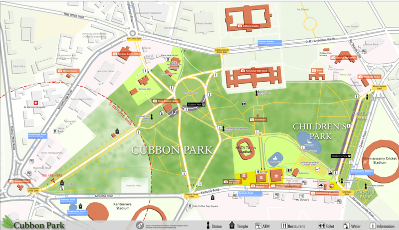
விளக்கம் Pedestrian Map for Cubbon park, Bangalore which was created as part of a class project at NID where we developed a system of navigation and wayfinding for visitors to the park. The ground survey was done by students and the data was collected using walking papers. All the data was then added to the openstreetmap database and then exported and processed in Adobe Illustrator for the final output.
நாள்
மூலம் OpenstreetMap, own work
ஆசிரியர் user:Planemad
Description
This map was created from OpenStreetMap project data, collected by the community. This map may be incomplete, and may contain errors. Don't rely solely on it for navigation.
நாள் (see file history)
மூலம் openstreetmap.org
படைப்பாளி
OpenStreetMap contributors
அனுமதி
(இக்கோப்பை மீண்டும் பயன்படுத்துதல்)
OpenStreetMap data and maps are licensed under the Creative Commons Attribution-ShareAlike 2.0 license (CC-BY-SA 2.0).
w:ta:கிரியேட்டிவ் காமன்ஸ்
பண்புக்கூறுகள் அதே மாதிரி பகிர்
This file is licensed under the Creative Commons Attribution-Share Alike 2.0 Generic license.
நீங்கள் சுதந்திரமாக:
  • பகிர்ந்து கொள்ள – வேலையை நகலெடுக்க, விநியோகிக்க மற்றும் அனுப்ப
  • மீண்டும் கலக்க – வேலைக்கு பழகிக்கொள்ள.
கீழ்க்காணும் விதிகளுக்கு ஏற்ப,
  • பண்புக்கூறுகள் – நீங்கள் பொருத்தமான உரிமையை வழங்க வேண்டும், உரிமத்திற்கான இணைப்பை வழங்க வேண்டும் மற்றும் மாற்றங்கள் செய்யப்பட்டிருந்தால் குறிப்பிட வேண்டும். நீங்கள் ஏற்புடைய எந்த முறையிலும் அவ்வாறு செய்யலாம், ஆனால் எந்த வகையிலும் உரிமதாரர் உங்களை அல்லது உங்கள் பயன்பாட்டிற்கு ஒப்புதல் அளிக்கும் படி பரிந்துரைக்க கூடாது.
  • அதே மாதிரி பகிர் – நீங்கள் ரீமிக்ஸ் செய்தாலோ, உருமாற்றம் செய்தாலோ அல்லது பொருளை உருவாக்கினாலோ, உங்கள் பங்களிப்புகளை அல்லது இணக்கமான உரிமம் கீழ் அசலாக விநியோகிக்க வேண்டும்.
Georeferencing Georeference the map in Wikimaps Warper If inappropriate please set warp_status = skip to hide.


அனுமதி

NATIONAL INSTITUTE OF DESIGN
Bangalore Campus

This is a work of a student or faculty from the National Institute of Design (India), 2024

CC-by-sa Arun Ganesh, National Institute of Design Bangalore
  • all works are licensed under Creative Commons Share Alike 3.0 license and must be used with the mentioned credit line.
  • all subsequent derivative works must be licensed under Creative Commons Share Alike 3.0
  • in case of a custom license, please contact the author or the image uploader.
  • for online use, a link back to this page must be provided
w:ta:கிரியேட்டிவ் காமன்ஸ்
பண்புக்கூறுகள் அதே மாதிரி பகிர்
இந்த கோப்பு Creative Commons Attribution-Share Alike 3.0 Unported உரிமத்தின் கீழ் உள்ளது.
நீங்கள் சுதந்திரமாக:
  • பகிர்ந்து கொள்ள – வேலையை நகலெடுக்க, விநியோகிக்க மற்றும் அனுப்ப
  • மீண்டும் கலக்க – வேலைக்கு பழகிக்கொள்ள.
கீழ்க்காணும் விதிகளுக்கு ஏற்ப,
  • பண்புக்கூறுகள் – நீங்கள் பொருத்தமான உரிமையை வழங்க வேண்டும், உரிமத்திற்கான இணைப்பை வழங்க வேண்டும் மற்றும் மாற்றங்கள் செய்யப்பட்டிருந்தால் குறிப்பிட வேண்டும். நீங்கள் ஏற்புடைய எந்த முறையிலும் அவ்வாறு செய்யலாம், ஆனால் எந்த வகையிலும் உரிமதாரர் உங்களை அல்லது உங்கள் பயன்பாட்டிற்கு ஒப்புதல் அளிக்கும் படி பரிந்துரைக்க கூடாது.
  • அதே மாதிரி பகிர் – நீங்கள் ரீமிக்ஸ் செய்தாலோ, உருமாற்றம் செய்தாலோ அல்லது பொருளை உருவாக்கினாலோ, உங்கள் பங்களிப்புகளை அல்லது இணக்கமான உரிமம் கீழ் அசலாக விநியோகிக்க வேண்டும்.

Captions

Add a one-line explanation of what this file represents

copyright status ஆங்கிலம்

copyrighted ஆங்கிலம்

29 ஏப்பிரல் 2010

checksum ஆங்கிலம்

e94cd40bfe8cf006895a482f9e0fb3a01fa58f9a

data size ஆங்கிலம்

10,21,136 பைட்டு

1,704 படவணு

2,953 படவணு

கோப்பின் வரலாறு

குறித்த நேரத்தில் இருந்த படிமத்தைப் பார்க்க அந்நேரத்தின் மீது சொடுக்கவும்.

நாள்/நேரம்நகம் அளவு சிறுபடம்அளவுகள்பயனர்கருத்து
தற்போதைய08:26, 2 சனவரி 201108:26, 2 சனவரி 2011 இலிருந்த பதிப்புக்கான சிறு தோற்றம்2,953 × 1,704 (997 KB)Planemadupdate, higher res
08:57, 24 சூலை 201008:57, 24 சூலை 2010 இலிருந்த பதிப்புக்கான சிறு தோற்றம்1,000 × 555 (192 KB)File Upload Bot (Magnus Manske){{Information |Description=Pedestrian Map for Cubbon park, bangaore which was created as part of a class project at NID where we developed a system of navigation and wayfinding for visitors to the park. I had a major role to play with the data collection

பின்வரும் பக்க இணைப்புகள் இப் படிமத்துக்கு இணைக்கபட்டுள்ளது(ளன):

கோப்பின் முழுமையான பயன்பாடு

கீழ்கண்ட மற்ற விக்கிகள் இந்த கோப்பை பயன்படுத்துகின்றன:

  • de.wikipedia.org-திட்டத்தில் இதன் பயன்பாடு
  • en.wikipedia.org-திட்டத்தில் இதன் பயன்பாடு
"https://ta.wikipedia.org/wiki/படிமம்:Cubbon_Park_OSM_Map.png" இலிருந்து மீள்விக்கப்பட்டது