படிமம்:Dissolution of Austria-Hungary.png
இந்த முன்னோட்டத்தின் அளவு: 800 × 473 படப்புள்ளிகள் . மற்ற பிரிதிறன்கள்: 320 × 189 படப்புள்ளிகள் | 640 × 378 படப்புள்ளிகள் | 1,024 × 605 படப்புள்ளிகள் | 1,641 × 970 படப்புள்ளிகள் .
மூலக்கோப்பு (1,641 × 970 படவணுக்கள், கோப்பின் அளவு: 182 KB, MIME வகை: image/png)
| இது விக்கிமீடியா பொதுக்கோப்பகத்தில் இருக்கும் ஒரு கோப்பாகும். இக்கோப்பைக் குறித்து அங்கே காணப்படும் படிம விளக்கப் பக்கத்தை இங்கே கீழே காணலாம்.
|

|
This map image could be re-created using vector graphics as an SVG file. This has several advantages; see Commons:Media for cleanup for more information. If an SVG form of this image is available, please upload it and afterwards replace this template with
{{vector version available|new image name}}.
It is recommended to name the SVG file “Dissolution of Austria-Hungary.svg”—then the template Vector version available (or Vva) does not need the new image name parameter. |
| விளக்கம் |
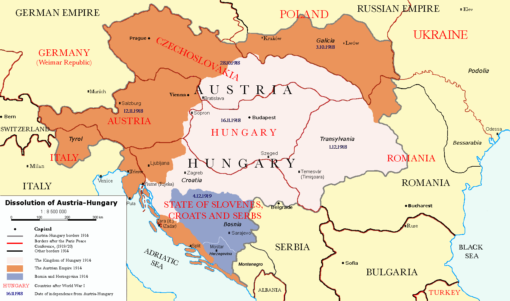
Čeština: Rozdělení Rakouska-Uherska po první světové válce, podle Pařížských předměstských smluv (Versailles s Německem, Saint-Germain-en-Laye s Rakouskem, Neuilly-sur-Seine s Bulharskem, Trianon s Maďarskem, Sèvres s Tureckem), dojednaných na Pařížské mírové konferenci (1919). Deutsch: Das Ende Österreich-Ungarns nach den Pariser Vorortverträgen. English: The end of Austria-Hungary after the Paris Treaty. Border of Austria-Hungary in 1914 Borders in 1914 Borders in 1920 Austrian Empire in 1914 Kingdom of Hungary in 1914 Bosnia and Herzegovina in 1914 |
| நாள் | (UTC) |
| மூலம் | |
| ஆசிரியர் |
|
| ஒத்தக்கோப்பு | العربيَّة |
| இது ஒரு திருத்தப்பட்ட படிமமாகும், அதாவது இதன் மூல வடிவத்திலிருந்து கணினி மூலம் இதில் மாற்றங்கள் செய்யப்பட்டுள்ளது. திருத்தங்கள்: translated to english. மூலக்கோப்பை இங்கு காணலாம்: Österreich-Ungarns Ende.png. திருத்தங்களைச் செய்தவர் P. S. Burton.
|
இந்த ஆக்கத்தின் காப்புரிமையாளரான நான் இதனைப் பின்வரும் உரிமத்தின் கீழ் வெளியிடுகின்றேன்:
| இந்த கோப்பு Creative Commons Attribution-Share Alike 3.0 Unported உரிமத்தின் கீழ் உள்ளது. | ||
| ||
| This licensing tag was added to this file as part of the GFDL licensing update. |

|
GNU Free Documentation License விதிமுறைகளின் கீழ் இந்த ஆவணத்தை நகலெடுக்க, விநியோகிக்க மற்றும்/அல்லது மாற்றுவதற்கு அனுமதி வழங்கப்பட்டுள்ளது, Free Software Foundation;ஆல் வெளியிடப்பட்ட பதிப்பு 1.2 அல்லது அதற்குப் பிந்தைய பதிப்பு, மாற்றமில்லாத பிரிவுகள், முன் அட்டை உரைகள் மற்றும் பின் அட்டை உரைகள் இல்லாமல் வெளியிடப்பட்டது. GNU Free Documentation License என்ற தலைப்பில் உரிமத்தின் நகல் சேர்க்கப்பட்டுள்ளது. |
நீர் உமக்கு விருப்பமான உரிமத்தை தேர்ந்தெடுக்கலாம்.
Original upload log
This image is a derivative work of the following images:
- File:Österreich-Ungarns_Ende.png licensed with Cc-by-sa-3.0-migrated, GFDL
- 2007-07-16T11:59:46Z Nihad Hamzic 1568x970 (81916 Bytes) The original image seems to had been saved as JPEG, and that some previous uploader had simply directly converted it to PNG. I have greatly optimised its size by removing JPEG artifacts, reducing color domain, etc.
- 2006-01-23T20:47:06Z AlphaCentauri 1568x970 (924912 Bytes) kleine Änderungen
- 2005-09-23T14:27:32Z AlphaCentauri 1568x970 (924912 Bytes) Laibach and Triest
- 2005-09-17T03:29:55Z Berkut 1568x970 (355556 Bytes) better file compression
- 2005-09-16T09:39:55Z Kallgan 1568x970 (438065 Bytes) Das Ende Österreich-Ungarns nach dem Pariser Vorortverträgen. Selbsterstellte Karte. {{Bild-GFDL}} (Borders between Romania and Bulgaria in Dobrogea modified)(Source: Goode's World Atlas, Rand McNally & Company, 1932 & 19
- 2005-07-04T13:39:25Z AlphaCentauri 1568x970 (924912 Bytes) verbessert
- 2005-04-28T19:29:14Z AlphaCentauri 1568x970 (924912 Bytes) so, nochmals verbessert
- 2005-04-12T18:45:25Z AlphaCentauri 1568x970 (924912 Bytes) nochmals verbessert
- 2005-04-12T15:06:42Z AlphaCentauri 1568x970 (924912 Bytes)
- 2005-04-12T14:47:08Z AlphaCentauri 1568x970 (924912 Bytes) verbesserte Version
- 2005-01-05T20:59:50Z AlphaCentauri 1568x970 (924912 Bytes) verbesserte Version
- 2004-12-29T10:14:48Z AlphaCentauri 1568x970 (924912 Bytes) Das Ende Österreich-Ungarns (Karte)
Uploaded with derivativeFX
கோப்பின் வரலாறு
குறித்த நேரத்தில் இருந்த படிமத்தைப் பார்க்க அந்நேரத்தின் மீது சொடுக்கவும்.
| நாள்/நேரம் | நகம் அளவு சிறுபடம் | அளவுகள் | பயனர் | கருத்து | |
|---|---|---|---|---|---|
| தற்போதைய | 17:57, 26 திசம்பர் 2021 | | 1,641 × 970 (182 KB) | Claude Zygiel | Cosmetic and correct romanian-ukrainian border since April 9, 1918 |
| 16:27, 6 திசம்பர் 2020 |  | 1,568 × 970 (175 KB) | Crash48 | before 1919, the Greek-Bulgarian border was far to the southwest | |
| 18:08, 3 திசம்பர் 2020 |  | 1,568 × 970 (175 KB) | Crash48 | Lwów didn't become Lviv until 1939 | |
| 16:37, 2 திசம்பர் 2020 |  | 1,568 × 970 (148 KB) | Crash48 | Romanian-Ukrainian border was way off; fixed according to File:Romania1901.JPG | |
| 15:20, 10 மார்ச்சு 2020 |  | 1,568 × 970 (229 KB) | Kufl | Odessa was never part of the Romania at that time | |
| 15:58, 10 அக்டோபர் 2013 |  | 1,568 × 970 (163 KB) | Lvivske | Incorrectly states that Ukraine was the Russian SFSR (Russia is not seen on the map), the area of Ukraine was the Ukraine post-WW1 and later following another war, the Ukrainian Soviet Socialist Republic, and joined ... | |
| 21:36, 24 நவம்பர் 2010 |  | 1,568 × 970 (164 KB) | P. S. Burton | Ungarn ->Hungary etc. | |
| 21:46, 23 நவம்பர் 2010 |  | 1,568 × 970 (163 KB) | P. S. Burton | Zara -> Zara (Zadar) | |
| 21:41, 23 நவம்பர் 2010 |  | 1,568 × 970 (163 KB) | P. S. Burton | Black Sea ->BLACK SEA | |
| 21:39, 23 நவம்பர் 2010 |  | 1,568 × 970 (163 KB) | P. S. Burton | {{Information |Description={{cs|Rozdělení Rakouska-Uherska po první světové válce, podle Pařížských předměstských smluv ([[:cs:Versailles|Ver |
கோப்பு பயன்பாடு
பின்வரும் பக்க இணைப்புகள் இப் படிமத்துக்கு இணைக்கபட்டுள்ளது(ளன):
கோப்பின் முழுமையான பயன்பாடு
கீழ்கண்ட மற்ற விக்கிகள் இந்த கோப்பை பயன்படுத்துகின்றன:
- ar.wikipedia.org-திட்டத்தில் இதன் பயன்பாடு
- azb.wikipedia.org-திட்டத்தில் இதன் பயன்பாடு
- ba.wikipedia.org-திட்டத்தில் இதன் பயன்பாடு
- ca.wikipedia.org-திட்டத்தில் இதன் பயன்பாடு
- de.wikipedia.org-திட்டத்தில் இதன் பயன்பாடு
- el.wikipedia.org-திட்டத்தில் இதன் பயன்பாடு
- en.wikipedia.org-திட்டத்தில் இதன் பயன்பாடு
- Austria-Hungary
- Nation state
- Dalmatia
- Aftermath of World War I
- Treaty of Saint-Germain-en-Laye (1919)
- World War I
- Anschluss
- Key events of the 20th century
- Wikipedia:Graphics Lab/Map workshop/Archive/Dec 2010
- Green Cadres
- Dissolution of Austria-Hungary
- Austria victim theory
- User:Falcaorib
- User:Lord Milner/Lord Milner Timeline
- User:Lord Milner/sandbox/Lord Milner's Life Timeline
- Draft:Timeline of Alfred Milner
- fr.wikipedia.org-திட்டத்தில் இதன் பயன்பாடு
- he.wikipedia.org-திட்டத்தில் இதன் பயன்பாடு
- hr.wikipedia.org-திட்டத்தில் இதன் பயன்பாடு
- hy.wikipedia.org-திட்டத்தில் இதன் பயன்பாடு
- id.wikipedia.org-திட்டத்தில் இதன் பயன்பாடு
- io.wikipedia.org-திட்டத்தில் இதன் பயன்பாடு
- it.wikipedia.org-திட்டத்தில் இதன் பயன்பாடு
- lmo.wikipedia.org-திட்டத்தில் இதன் பயன்பாடு
- lt.wikipedia.org-திட்டத்தில் இதன் பயன்பாடு
- no.wikipedia.org-திட்டத்தில் இதன் பயன்பாடு
- pnb.wikipedia.org-திட்டத்தில் இதன் பயன்பாடு
- pt.wikipedia.org-திட்டத்தில் இதன் பயன்பாடு
- ro.wikipedia.org-திட்டத்தில் இதன் பயன்பாடு
- sh.wikipedia.org-திட்டத்தில் இதன் பயன்பாடு
- sv.wikipedia.org-திட்டத்தில் இதன் பயன்பாடு
- th.wikipedia.org-திட்டத்தில் இதன் பயன்பாடு
சிறப்பு பக்கம்-மொத்த பயன்பாடு - இதன் மூலம் இந்த கோப்பின் மொத்த பயன்பாட்டை அறிய முடியும்