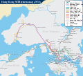
படிமம்:Hong Kong Railway Route Map en.svg

Size of this PNG preview of this SVG file: 655 × 599 படப்புள்ளிகள். மற்ற பிரிதிறன்கள்: 262 × 240 படப்புள்ளிகள் | 525 × 480 படப்புள்ளிகள் | 839 × 768 படப்புள்ளிகள் | 1,119 × 1,024 படப்புள்ளிகள் | 2,238 × 2,048 படப்புள்ளிகள் | 1,557 × 1,425 படப்புள்ளிகள் .
மூலக்கோப்பு (SVG கோப்பு, பெயரளவில் 1,557 × 1,425 பிக்சல்கள், கோப்பு அளவு: 75 KB)
கோப்பின் வரலாறு
குறித்த நேரத்தில் இருந்த படிமத்தைப் பார்க்க அந்நேரத்தின் மீது சொடுக்கவும்.
| நாள்/நேரம் | நகம் அளவு சிறுபடம் | அளவுகள் | பயனர் | கருத்து | |
|---|---|---|---|---|---|
| தற்போதைய | 14:56, 6 செப்டெம்பர் 2022 |  | 1,557 × 1,425 (75 KB) | Lyvrus | File uploaded using svgtranslate tool (https://svgtranslate.toolforge.org/). Added translation for ru. |
| 13:05, 14 மே 2022 |  | 1,557 × 1,425 (74 KB) | Jc86035 | East Rail Line cross-harbour extension | |
| 00:54, 6 சூலை 2021 |  | 1,557 × 1,425 (74 KB) | Sameboat | 屯馬綫。請勿使用文字編輯器以外的軟件儲存本SVG檔案導致代碼破損!!! | |
| 15:26, 3 சூன் 2020 |  | 1,050 × 1,024 (208 KB) | Painjet | fix | |
| 14:09, 3 சூன் 2020 |  | 1,038 × 950 (105 KB) | Painjet | Update Tuen Ma line Phase 1 | |
| 00:19, 15 சனவரி 2020 |  | 1,038 × 950 (75 KB) | MSG17 | File uploaded using svgtranslate tool (https://tools.wmflabs.org/svgtranslate/). Added translation for ru. | |
| 18:48, 14 சனவரி 2020 |  | 1,038 × 950 (60 KB) | MSG17 | File uploaded using svgtranslate tool (https://tools.wmflabs.org/svgtranslate/). Added translation for ta. | |
| 17:00, 14 சனவரி 2020 |  | 1,038 × 950 (56 KB) | MSG17 | File uploaded using svgtranslate tool (https://tools.wmflabs.org/svgtranslate/). Added translation for ta. | |
| 16:56, 14 சனவரி 2020 |  | 1,038 × 950 (55 KB) | MSG17 | File uploaded using svgtranslate tool (https://tools.wmflabs.org/svgtranslate/). Added translation for ta. | |
| 15:05, 15 சூலை 2018 |  | 1,038 × 950 (38 KB) | Sameboat | doctype |
கோப்பு பயன்பாடு
பின்வரும் 2 பக்கங்கள் இணைப்பு இப் படிமத்துக்கு இணைக்கபட்டுள்ளது(ளன):
கோப்பின் முழுமையான பயன்பாடு
கீழ்கண்ட மற்ற விக்கிகள் இந்த கோப்பை பயன்படுத்துகின்றன:
- ang.wikipedia.org-திட்டத்தில் இதன் பயன்பாடு
- ca.wikipedia.org-திட்டத்தில் இதன் பயன்பாடு
- de.wikipedia.org-திட்டத்தில் இதன் பயன்பாடு
- en.wikipedia.org-திட்டத்தில் இதன் பயன்பாடு
- en.wikivoyage.org-திட்டத்தில் இதன் பயன்பாடு
- eo.wikipedia.org-திட்டத்தில் இதன் பயன்பாடு
- es.wikipedia.org-திட்டத்தில் இதன் பயன்பாடு
- eu.wikipedia.org-திட்டத்தில் இதன் பயன்பாடு
- fa.wikipedia.org-திட்டத்தில் இதன் பயன்பாடு
- fi.wikipedia.org-திட்டத்தில் இதன் பயன்பாடு
- fr.wikipedia.org-திட்டத்தில் இதன் பயன்பாடு
- fr.wikivoyage.org-திட்டத்தில் இதன் பயன்பாடு
- ga.wikipedia.org-திட்டத்தில் இதன் பயன்பாடு
- gl.wikipedia.org-திட்டத்தில் இதன் பயன்பாடு
- he.wikipedia.org-திட்டத்தில் இதன் பயன்பாடு
- he.wikivoyage.org-திட்டத்தில் இதன் பயன்பாடு
- hu.wikipedia.org-திட்டத்தில் இதன் பயன்பாடு
- id.wikipedia.org-திட்டத்தில் இதன் பயன்பாடு
- it.wikipedia.org-திட்டத்தில் இதன் பயன்பாடு
- it.wikivoyage.org-திட்டத்தில் இதன் பயன்பாடு
- ja.wikipedia.org-திட்டத்தில் இதன் பயன்பாடு
சிறப்பு பக்கம்-மொத்த பயன்பாடு - இதன் மூலம் இந்த கோப்பின் மொத்த பயன்பாட்டை அறிய முடியும்

