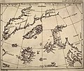
படிமம்:Map by nicolo zeno 1558.jpg

இந்த முன்னோட்டத்தின் அளவு: 716 × 600 படப்புள்ளிகள் . மற்ற பிரிதிறன்கள்: 287 × 240 படப்புள்ளிகள் | 573 × 480 படப்புள்ளிகள் | 917 × 768 படப்புள்ளிகள் | 1,024 × 858 படப்புள்ளிகள் .
மூலக்கோப்பு (1,024 × 858 படவணுக்கள், கோப்பின் அளவு: 299 KB, MIME வகை: image/jpeg)
கோப்பின் வரலாறு
குறித்த நேரத்தில் இருந்த படிமத்தைப் பார்க்க அந்நேரத்தின் மீது சொடுக்கவும்.
| நாள்/நேரம் | நகம் அளவு சிறுபடம் | அளவுகள் | பயனர் | கருத்து | |
|---|---|---|---|---|---|
| தற்போதைய | 19:08, 22 செப்டெம்பர் 2020 |  | 1,024 × 858 (299 KB) | Hohum | Cleanup |
| 00:27, 11 மே 2007 |  | 1,024 × 858 (167 KB) | Petri Krohn | Reverted to earlier revision | |
| 14:37, 12 மே 2005 |  | 1,015 × 852 (289 KB) | Luestling~commonswiki | ||
| 00:18, 18 ஏப்பிரல் 2005 |  | 1,024 × 858 (167 KB) | Simplicius | Map by Nicolo Zeno, 1558, published by Henrich Peter von Eggers 1793. {{pd-old}} |
கோப்பு பயன்பாடு
பின்வரும் பக்க இணைப்புகள் இப் படிமத்துக்கு இணைக்கபட்டுள்ளது(ளன):
கோப்பின் முழுமையான பயன்பாடு
கீழ்கண்ட மற்ற விக்கிகள் இந்த கோப்பை பயன்படுத்துகின்றன:
- ar.wikipedia.org-திட்டத்தில் இதன் பயன்பாடு
- bn.wikipedia.org-திட்டத்தில் இதன் பயன்பாடு
- bs.wikipedia.org-திட்டத்தில் இதன் பயன்பாடு
- ca.wikipedia.org-திட்டத்தில் இதன் பயன்பாடு
- cs.wikipedia.org-திட்டத்தில் இதன் பயன்பாடு
- da.wikipedia.org-திட்டத்தில் இதன் பயன்பாடு
- de.wikipedia.org-திட்டத்தில் இதன் பயன்பாடு
- de.wiktionary.org-திட்டத்தில் இதன் பயன்பாடு
- en.wikipedia.org-திட்டத்தில் இதன் பயன்பாடு
- eo.wikipedia.org-திட்டத்தில் இதன் பயன்பாடு
- es.wikipedia.org-திட்டத்தில் இதன் பயன்பாடு
- fa.wikipedia.org-திட்டத்தில் இதன் பயன்பாடு
- fi.wikipedia.org-திட்டத்தில் இதன் பயன்பாடு
- fo.wikipedia.org-திட்டத்தில் இதன் பயன்பாடு
- frp.wikipedia.org-திட்டத்தில் இதன் பயன்பாடு
- fr.wikipedia.org-திட்டத்தில் இதன் பயன்பாடு
- fy.wikipedia.org-திட்டத்தில் இதன் பயன்பாடு
- he.wikipedia.org-திட்டத்தில் இதன் பயன்பாடு
- hi.wikipedia.org-திட்டத்தில் இதன் பயன்பாடு
- id.wikipedia.org-திட்டத்தில் இதன் பயன்பாடு
- it.wikipedia.org-திட்டத்தில் இதன் பயன்பாடு
சிறப்பு பக்கம்-மொத்த பயன்பாடு - இதன் மூலம் இந்த கோப்பின் மொத்த பயன்பாட்டை அறிய முடியும்