படிமம்:Nazi Germany.png

இந்த முன்னோட்டத்தின் அளவு: 772 × 600 படப்புள்ளிகள் . மற்ற பிரிதிறன்கள்: 309 × 240 படப்புள்ளிகள் | 618 × 480 படப்புள்ளிகள் | 989 × 768 படப்புள்ளிகள் | 1,200 × 932 படப்புள்ளிகள் .
மூலக்கோப்பு (1,200 × 932 படவணுக்கள், கோப்பின் அளவு: 263 KB, MIME வகை: image/png)
| இது விக்கிமீடியா பொதுக்கோப்பகத்தில் இருக்கும் ஒரு கோப்பாகும். இக்கோப்பைக் குறித்து அங்கே காணப்படும் படிம விளக்கப் பக்கத்தை இங்கே கீழே காணலாம்.
|
Template loop detected: Template:Autotranslate <includeonly></includeonly>
சுருக்கம்
| விளக்கம் |
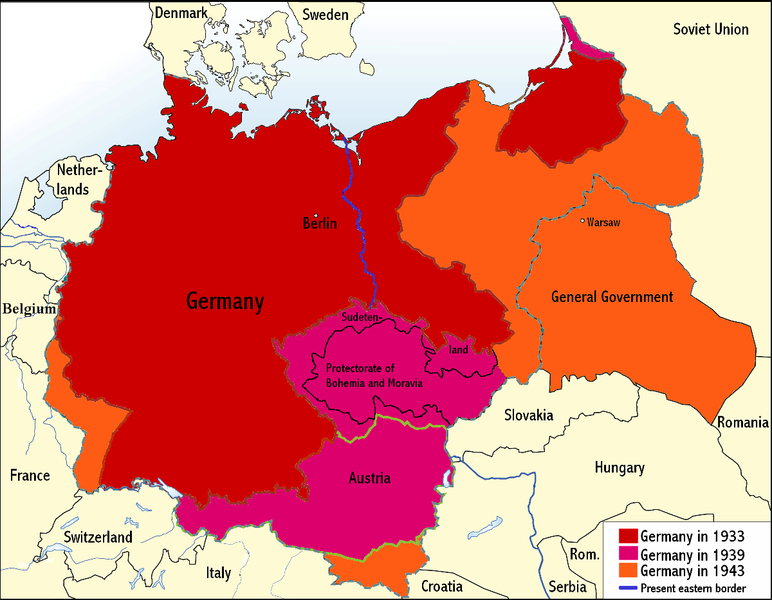
English: An overview map of Nazi Germany to 1943. |
||||||||
| நாள் | |||||||||
| மூலம் | Transferred from the English Wikipedia. Original file is/was here. (Original upload log available below.) | ||||||||
| ஆசிரியர் | Wikinist | ||||||||
| அனுமதி (இக்கோப்பை மீண்டும் பயன்படுத்துதல்) |
|
||||||||
| ஒத்தக்கோப்பு |
Derivative works of this file: Nazi Germany-it.svg |


Original upload log
All the following user names refer to the English Wikipedia.
| Date/Time | Dimensions | User | Comment |
|---|---|---|---|
| 00:03, 24 June 2008 | 1,200×932 (275 KB) |
Wikinist | (Belgia -> Belgium) |
| 00:52, 30 April 2008 | 1,200×932 (286 KB) |
R-41 | (Removed swastika from map. The title "Germany" is moved up to the centre of Germany on the map now.) |
| 21:37, 29 April 2008 | 1,200×932 (291 KB) |
Wikinist | (== Description== {{Information |Description=An overview map of Nazi Germany, based on another map[http://en.wikipedia.org/wiki/Image:GDR.png] by [[:de:Benutzer:kgberger|kgberger]]. Placenames replaced with English ones, resolution decreased, a lot of info) |
கோப்பின் வரலாறு
குறித்த நேரத்தில் இருந்த படிமத்தைப் பார்க்க அந்நேரத்தின் மீது சொடுக்கவும்.
| நாள்/நேரம் | நகம் அளவு சிறுபடம் | அளவுகள் | பயனர் | கருத்து | |
|---|---|---|---|---|---|
| தற்போதைய | 23:35, 6 சூன் 2009 | | 1,200 × 932 (263 KB) | MaggotMaster | Reverted to version as of 22:18, 21 May 2009 |
| 11:57, 4 சூன் 2009 |  | 1,200 × 932 (234 KB) | Fz22~commonswiki | {{Information |Description= |Source= |Date= |Author= |Permission= |other_versions= }} | |
| 22:18, 21 மே 2009 |  | 1,200 × 932 (263 KB) | Hohum | Reduced garish colour intensity. | |
| 09:30, 19 சனவரி 2009 |  | 1,200 × 932 (207 KB) | Brianski | clean up the legend | |
| 20:20, 8 அக்டோபர் 2008 |  | 1,200 × 932 (275 KB) | File Upload Bot (Magnus Manske) | {{BotMoveToCommons|en.wikipedia}} {{Information |Description={{en|An overview map of Nazi Germany, based on another map (en::Image:GDR.png) by kgberger. Placenames replaced with English ones, resolution decreased, a lot |
கோப்பு பயன்பாடு
இப் படிமத்துக்கு இணைக்கப்பட்டுள்ள பக்கங்கள் எதுவும் இல்லை.
கோப்பின் முழுமையான பயன்பாடு
கீழ்கண்ட மற்ற விக்கிகள் இந்த கோப்பை பயன்படுத்துகின்றன:
- la.wikipedia.org-திட்டத்தில் இதன் பயன்பாடு
- pt.wikipedia.org-திட்டத்தில் இதன் பயன்பாடு