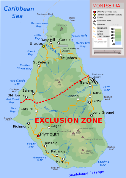
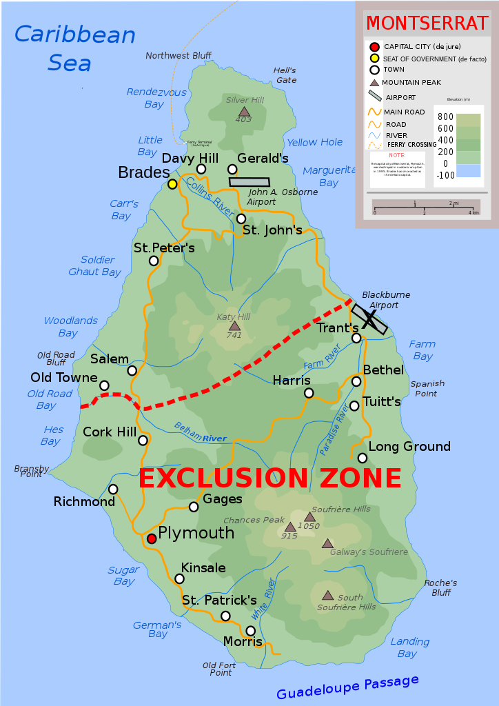
படிமம்:Topographic-map-of-Montserrat-en.svg

Size of this PNG preview of this SVG file: 424 × 600 படப்புள்ளிகள். மற்ற பிரிதிறன்கள்: 170 × 240 படப்புள்ளிகள் | 339 × 480 படப்புள்ளிகள் | 543 × 768 படப்புள்ளிகள் | 724 × 1,024 படப்புள்ளிகள் | 1,448 × 2,048 படப்புள்ளிகள் | 744 × 1,052 படப்புள்ளிகள் .
மூலக்கோப்பு (SVG கோப்பு, பெயரளவில் 744 × 1,052 பிக்சல்கள், கோப்பு அளவு: 183 KB)
| இது விக்கிமீடியா பொதுக்கோப்பகத்தில் இருக்கும் ஒரு கோப்பாகும். இக்கோப்பைக் குறித்து அங்கே காணப்படும் படிம விளக்கப் பக்கத்தை இங்கே கீழே காணலாம்.
|
| விளக்கம் | Topographic map of Montserrat in English |
| நாள் | |
| மூலம் | சொந்த முயற்சி |
| ஆசிரியர் | Ivan25 |
| ஒத்தக்கோப்பு |
[]
Derivative works of this file: |
| SVG genesis |


| I, the copyright holder of this work, release this work into the public domain. This applies worldwide. சில நாடுகளில் இது சாத்தியமில்லாது போகலாம். அவ்வாறாயின் : I grant anyone the right to use this work for any purpose, without any conditions, unless such conditions are required by law. |
கோப்பின் வரலாறு
குறித்த நேரத்தில் இருந்த படிமத்தைப் பார்க்க அந்நேரத்தின் மீது சொடுக்கவும்.
| நாள்/நேரம் | நகம் அளவு சிறுபடம் | அளவுகள் | பயனர் | கருத்து | |
|---|---|---|---|---|---|
| தற்போதைய | 09:00, 11 செப்டெம்பர் 2022 | | 744 × 1,052 (183 KB) | KajenCAT | File uploaded using svgtranslate tool (https://svgtranslate.toolforge.org/). Added translation for ca. |
| 19:46, 10 செப்டெம்பர் 2022 |  | 744 × 1,052 (178 KB) | KajenCAT | File uploaded using svgtranslate tool (https://svgtranslate.toolforge.org/). Added translation for ca. | |
| 19:46, 10 செப்டெம்பர் 2022 |  | 744 × 1,052 (178 KB) | KajenCAT | File uploaded using svgtranslate tool (https://svgtranslate.toolforge.org/). Added translation for ca. | |
| 19:45, 10 செப்டெம்பர் 2022 |  | 744 × 1,052 (177 KB) | KajenCAT | File uploaded using svgtranslate tool (https://svgtranslate.toolforge.org/). Added translation for ca. | |
| 19:42, 30 ஆகத்து 2022 |  | 744 × 1,052 (163 KB) | HapHaxion | fix missing note | |
| 19:37, 30 ஆகத்து 2022 |  | 744 × 1,052 (162 KB) | HapHaxion | reduce file size | |
| 12:08, 6 ஏப்பிரல் 2017 |  | 744 × 1,052 (264 KB) | RaviC | + Ferry | |
| 19:49, 13 சூன் 2011 |  | 744 × 1,052 (260 KB) | Kmusser | additions copied from German version | |
| 15:51, 19 ஏப்பிரல் 2011 |  | 744 × 1,052 (250 KB) | Grandiose | Fix scale, which was clearly incorrect. | |
| 14:39, 16 சூலை 2010 |  | 744 × 1,052 (250 KB) | Ivan25 | further changes: added new capital, legend changed, water color equalized. |
கோப்பு பயன்பாடு
பின்வரும் பக்க இணைப்புகள் இப் படிமத்துக்கு இணைக்கபட்டுள்ளது(ளன):
கோப்பின் முழுமையான பயன்பாடு
கீழ்கண்ட மற்ற விக்கிகள் இந்த கோப்பை பயன்படுத்துகின்றன:
- ca.wikipedia.org-திட்டத்தில் இதன் பயன்பாடு
- cs.wikipedia.org-திட்டத்தில் இதன் பயன்பாடு
- da.wikipedia.org-திட்டத்தில் இதன் பயன்பாடு
- de.wikipedia.org-திட்டத்தில் இதன் பயன்பாடு
- en.wikipedia.org-திட்டத்தில் இதன் பயன்பாடு
- fa.wikipedia.org-திட்டத்தில் இதன் பயன்பாடு
- fr.wikipedia.org-திட்டத்தில் இதன் பயன்பாடு
- ga.wikipedia.org-திட்டத்தில் இதன் பயன்பாடு
- gl.wikipedia.org-திட்டத்தில் இதன் பயன்பாடு
- id.wikipedia.org-திட்டத்தில் இதன் பயன்பாடு
- li.wikipedia.org-திட்டத்தில் இதன் பயன்பாடு
- lt.wikipedia.org-திட்டத்தில் இதன் பயன்பாடு
- ml.wikipedia.org-திட்டத்தில் இதன் பயன்பாடு
- mt.wikipedia.org-திட்டத்தில் இதன் பயன்பாடு
- nl.wikipedia.org-திட்டத்தில் இதன் பயன்பாடு
- nn.wikipedia.org-திட்டத்தில் இதன் பயன்பாடு
- no.wikipedia.org-திட்டத்தில் இதன் பயன்பாடு
- pap.wikipedia.org-திட்டத்தில் இதன் பயன்பாடு
- pa.wikipedia.org-திட்டத்தில் இதன் பயன்பாடு
- pcd.wikipedia.org-திட்டத்தில் இதன் பயன்பாடு
- shn.wikipedia.org-திட்டத்தில் இதன் பயன்பாடு
- sq.wikipedia.org-திட்டத்தில் இதன் பயன்பாடு
- su.wikipedia.org-திட்டத்தில் இதன் பயன்பாடு
- tr.wikipedia.org-திட்டத்தில் இதன் பயன்பாடு
- tt.wikipedia.org-திட்டத்தில் இதன் பயன்பாடு
- uk.wikipedia.org-திட்டத்தில் இதன் பயன்பாடு
- vi.wikipedia.org-திட்டத்தில் இதன் பயன்பாடு
- www.wikidata.org-திட்டத்தில் இதன் பயன்பாடு
- yo.wikipedia.org-திட்டத்தில் இதன் பயன்பாடு
- zh.wikipedia.org-திட்டத்தில் இதன் பயன்பாடு