படிமம்:Zabul districts.png

இந்த முன்னோட்டத்தின் அளவு: 789 × 600 படப்புள்ளிகள் . மற்ற பிரிதிறன்கள்: 316 × 240 படப்புள்ளிகள் | 632 × 480 படப்புள்ளிகள் | 1,000 × 760 படப்புள்ளிகள் .
மூலக்கோப்பு (1,000 × 760 படவணுக்கள், கோப்பின் அளவு: 19 KB, MIME வகை: image/png)
| இது விக்கிமீடியா பொதுக்கோப்பகத்தில் இருக்கும் ஒரு கோப்பாகும். இக்கோப்பைக் குறித்து அங்கே காணப்படும் படிம விளக்கப் பக்கத்தை இங்கே கீழே காணலாம்.
|

|
This map image could be re-created using vector graphics as an SVG file. This has several advantages; see Commons:Media for cleanup for more information. If an SVG form of this image is available, please upload it and afterwards replace this template with
{{vector version available|new image name}}.
It is recommended to name the SVG file “Zabul districts.svg”—then the template Vector version available (or Vva) does not need the new image name parameter. |
சுருக்கம்
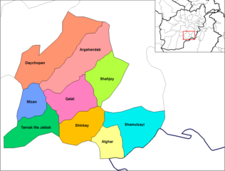
English: Map of the districts of Zabol province of Afghanistan. Created by Rarelibra 19:34, 29 March 2007 (UTC) for public domain use, using MapInfo Professional v8.5 and various mapping resources.
அனுமதி
| This work has been released into the public domain by its author, Rarelibra. This applies worldwide. சில நாடுகளில் இது சாத்தியமில்லாது போகலாம். அவ்வாறாயின் : |
Original upload log
| date/time | username | resolution | size | edit summary | |
|---|---|---|---|---|---|
| 19:34, 29 March 2007 | User:Rarelibra | <a href="http://upload.wikimedia.org/wikipedia/commons/b/bc/Zabol_districts.png"><img alt="Thumbnail for version as of 19:34, 29 March 2007" src="http://upload.wikimedia.org/wikipedia/commons/thumb/b/bc/Zabol_districts.png/120px-Zabol_districts.png" width="120" height="93" border="0" /></a> | 1,056×816 | 29 KB | Map of the districts of Zabol province of Afghanistan. Created by ~~~~ for public domain use, using MapInfo Professional v8.5 and various mapping resources. |
கோப்பின் வரலாறு
குறித்த நேரத்தில் இருந்த படிமத்தைப் பார்க்க அந்நேரத்தின் மீது சொடுக்கவும்.
| நாள்/நேரம் | நகம் அளவு சிறுபடம் | அளவுகள் | பயனர் | கருத்து | |
|---|---|---|---|---|---|
| தற்போதைய | 19:14, 14 பெப்பிரவரி 2024 | | 1,000 × 760 (19 KB) | User-duck | Cropped 5 % horizontally, 7 % vertically using CropTool with lossless mode. |
| 21:43, 12 மார்ச்சு 2009 |  | 1,056 × 816 (29 KB) | BetacommandBot | move approved by: User:Lokal Profil This image was moved from File:Zabol districts.png == Summary == Map of the districts of Zabol province of Afghanistan. Created by Rarelibra 19:34, 29 March 2007 (UTC) for public domain use |
கோப்பு பயன்பாடு
பின்வரும் பக்க இணைப்புகள் இப் படிமத்துக்கு இணைக்கபட்டுள்ளது(ளன):
கோப்பின் முழுமையான பயன்பாடு
கீழ்கண்ட மற்ற விக்கிகள் இந்த கோப்பை பயன்படுத்துகின்றன:
- ar.wikipedia.org-திட்டத்தில் இதன் பயன்பாடு
- ca.wikipedia.org-திட்டத்தில் இதன் பயன்பாடு
- da.wikipedia.org-திட்டத்தில் இதன் பயன்பாடு
- de.wikipedia.org-திட்டத்தில் இதன் பயன்பாடு
- en.wikipedia.org-திட்டத்தில் இதன் பயன்பாடு
- eo.wikipedia.org-திட்டத்தில் இதன் பயன்பாடு
- es.wikipedia.org-திட்டத்தில் இதன் பயன்பாடு
- fi.wikipedia.org-திட்டத்தில் இதன் பயன்பாடு
- fr.wikipedia.org-திட்டத்தில் இதன் பயன்பாடு
- he.wikipedia.org-திட்டத்தில் இதன் பயன்பாடு
- incubator.wikimedia.org-திட்டத்தில் இதன் பயன்பாடு
- it.wikipedia.org-திட்டத்தில் இதன் பயன்பாடு
- lt.wikipedia.org-திட்டத்தில் இதன் பயன்பாடு
- mn.wikipedia.org-திட்டத்தில் இதன் பயன்பாடு
- ms.wikipedia.org-திட்டத்தில் இதன் பயன்பாடு
- nl.wikipedia.org-திட்டத்தில் இதன் பயன்பாடு
- no.wikipedia.org-திட்டத்தில் இதன் பயன்பாடு
- pl.wikipedia.org-திட்டத்தில் இதன் பயன்பாடு
- pnb.wikipedia.org-திட்டத்தில் இதன் பயன்பாடு
- ps.wikipedia.org-திட்டத்தில் இதன் பயன்பாடு
- pt.wikipedia.org-திட்டத்தில் இதன் பயன்பாடு
- ru.wikipedia.org-திட்டத்தில் இதன் பயன்பாடு
- simple.wikipedia.org-திட்டத்தில் இதன் பயன்பாடு
- sk.wikipedia.org-திட்டத்தில் இதன் பயன்பாடு
- tr.wikipedia.org-திட்டத்தில் இதன் பயன்பாடு
- ur.wikipedia.org-திட்டத்தில் இதன் பயன்பாடு
- uz.wikipedia.org-திட்டத்தில் இதன் பயன்பாடு