படிமம்:IGI1908Beluchistan2.jpg

இந்த முன்னோட்டத்தின் அளவு: 723 × 599 படப்புள்ளிகள் . மற்ற பிரிதிறன்கள்: 290 × 240 படப்புள்ளிகள் | 579 × 480 படப்புள்ளிகள் | 926 × 768 படப்புள்ளிகள் | 1,200 × 995 படப்புள்ளிகள் .
மூலக்கோப்பு (1,200 × 995 படவணுக்கள், கோப்பின் அளவு: 372 KB, MIME வகை: image/jpeg)
| இது விக்கிமீடியா பொதுக்கோப்பகத்தில் இருக்கும் ஒரு கோப்பாகும். இக்கோப்பைக் குறித்து அங்கே காணப்படும் படிம விளக்கப் பக்கத்தை இங்கே கீழே காணலாம்.
|
சுருக்கம்
| Description |
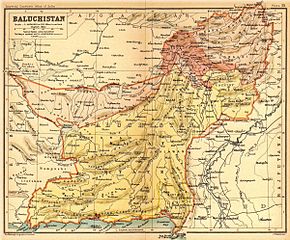
English: Map of Beluchistan |
|||||||||
| நாள் | ||||||||||
| மூலம் | Imperial Gazetteer of India, volume 26, Atlas, Oxford University Press. 1908. Scanned from personal copy, reduced, and uploaded by Fowler&fowler«Talk» 22:36, 8 March 2009 (UTC) | |||||||||
| படைப்பாளி |
J. G. Bartholomew and Co., Edinburgh |
|||||||||
| Geotemporal data | ||||||||||
| Bounding box |
|
|||||||||
| Georeferencing | ||||||||||
அனுமதி
The author died in 1920, so this work is in the public domain in its country of origin and other countries and areas where the copyright term is the author's life plus 100 years or fewer. | |
| This file has been identified as being free of known restrictions under copyright law, including all related and neighboring rights. | |
Original upload log
The original description page was here. All following user names refer to en.wikipedia.
- 2010-04-18 16:18 Beao 1200×995× (380628 bytes)
- 2009-03-08 22:36 Fowler&fowler 1200×995× (345178 bytes) {{Information |Description=Map of Beluchistan from ''Imperial Gazetteer of India'', volume 26, Atlas, Oxford University Press. 1908. Scanned from personal copy, reduced, and uploaded by ~~~~ |Source=''Imperial Gazetteer of India'', volume 26, Atlas, Oxf
கோப்பின் வரலாறு
குறித்த நேரத்தில் இருந்த படிமத்தைப் பார்க்க அந்நேரத்தின் மீது சொடுக்கவும்.
| நாள்/நேரம் | நகம் அளவு சிறுபடம் | அளவுகள் | பயனர் | கருத்து | |
|---|---|---|---|---|---|
| தற்போதைய | 21:36, 19 நவம்பர் 2011 | | 1,200 × 995 (372 KB) | OgreBot | (BOT): Reverting to most recent version before archival |
| 21:35, 19 நவம்பர் 2011 |  | 1,200 × 995 (337 KB) | OgreBot | (BOT): Uploading old version of file from en.wikipedia; originally uploaded on 2009-03-08 22:36:49 by Fowler&fowler | |
| 11:29, 2 மார்ச்சு 2011 |  | 1,200 × 995 (372 KB) | MALLUS | {{Information |Description=Map of Beluchistan from ''Imperial Gazetteer of India'', volume 26, Atlas, Oxford University Press. 1908. Scanned from personal copy, reduced, and uploaded by [[User:Fowler&fowler|<font color="#B8860B">Fowler&fowler</f |
கோப்பு பயன்பாடு
பின்வரும் பக்க இணைப்புகள் இப் படிமத்துக்கு இணைக்கபட்டுள்ளது(ளன):
கோப்பின் முழுமையான பயன்பாடு
கீழ்கண்ட மற்ற விக்கிகள் இந்த கோப்பை பயன்படுத்துகின்றன:
- bn.wikipedia.org-திட்டத்தில் இதன் பயன்பாடு
- ca.wikipedia.org-திட்டத்தில் இதன் பயன்பாடு
- it.wikipedia.org-திட்டத்தில் இதன் பயன்பாடு
- no.wikipedia.org-திட்டத்தில் இதன் பயன்பாடு
- pt.wikipedia.org-திட்டத்தில் இதன் பயன்பாடு
- te.wikipedia.org-திட்டத்தில் இதன் பயன்பாடு