படிமம்:IslamicConquestsIroon.png
இந்த முன்னோட்டத்தின் அளவு: 675 × 599 படப்புள்ளிகள் . மற்ற பிரிதிறன்கள்: 270 × 240 படப்புள்ளிகள் | 541 × 480 படப்புள்ளிகள் | 1,006 × 893 படப்புள்ளிகள் .
மூலக்கோப்பு (1,006 × 893 படவணுக்கள், கோப்பின் அளவு: 105 KB, MIME வகை: image/png)
| இது விக்கிமீடியா பொதுக்கோப்பகத்தில் இருக்கும் ஒரு கோப்பாகும். இக்கோப்பைக் குறித்து அங்கே காணப்படும் படிம விளக்கப் பக்கத்தை இங்கே கீழே காணலாம்.
|

|
This historical map image could be re-created using vector graphics as an SVG file. This has several advantages; see Commons:Media for cleanup for more information. If an SVG form of this image is available, please upload it and afterwards replace this template with
{{vector version available|new image name}}.
It is recommended to name the SVG file “IslamicConquestsIroon.svg”—then the template Vector version available (or Vva) does not need the new image name parameter. |
| விளக்கம் |
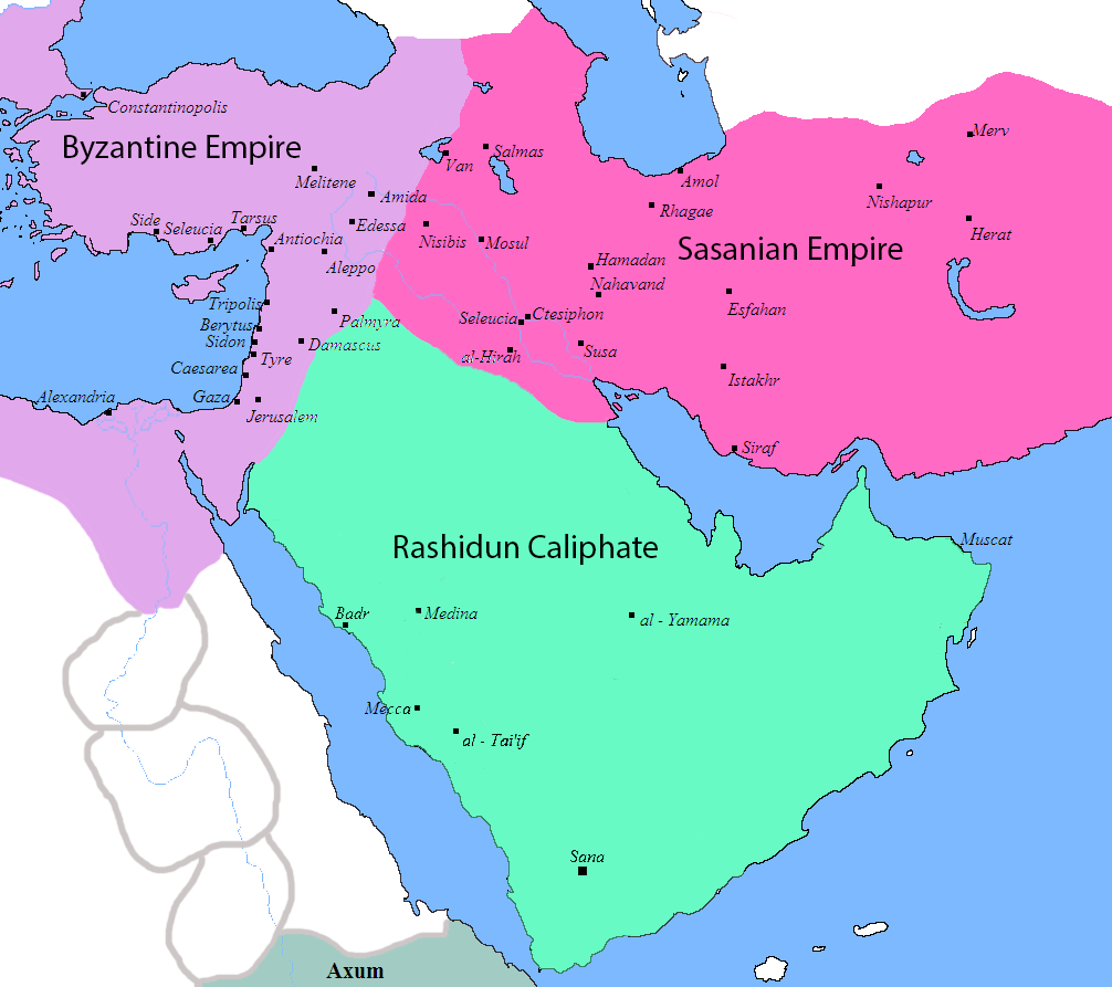
English: Map of the Sassanid, Byzantine and Muslim borders. |
| மூலம் | File:Pre_Islamic_Arabia.PNG |
| ஆசிரியர் | Javierfv1212 and edited by HistoryofIran. |
| ஒத்தக்கோப்பு |
[]
|


This file is in the public domain because File:Pre_Islamic_Arabia.PNG
|
கோப்பின் வரலாறு
குறித்த நேரத்தில் இருந்த படிமத்தைப் பார்க்க அந்நேரத்தின் மீது சொடுக்கவும்.
| நாள்/நேரம் | நகம் அளவு சிறுபடம் | அளவுகள் | பயனர் | கருத்து | |
|---|---|---|---|---|---|
| தற்போதைய | 10:13, 18 செப்டெம்பர் 2019 | | 1,006 × 893 (105 KB) | HistoryofIran | rv, thats not how it works |
| 04:51, 18 செப்டெம்பர் 2019 |  | 1,006 × 893 (103 KB) | Сахалин21 | Under Hormizd IV, Persia won the Perso-Turkic War and conquered Samarqand and the Transoxiania. | |
| 04:50, 18 செப்டெம்பர் 2019 |  | 1,006 × 893 (105 KB) | Сахалин21 | Reverted to version as of 01:15, 3 August 2019 (UTC) | |
| 04:45, 18 செப்டெம்பர் 2019 |  | 1,006 × 893 (103 KB) | Сахалин21 | Reverted to version as of 19:13, 14 November 2017 (UTC) | |
| 01:15, 3 ஆகத்து 2019 |  | 1,006 × 893 (105 KB) | HistoryofIran | rv, no, they weren't at all | |
| 18:38, 1 ஆகத்து 2019 |  | 1,006 × 893 (105 KB) | Mehrdad 12 | The eastern borders were conquered during the reign of Queen Purandokht. | |
| 18:34, 1 ஆகத்து 2019 |  | 1,006 × 893 (106 KB) | Mehrdad 12 | I corrected the eastern borders. The Great Khorasan and Khwarizmi Desert were considered imperial. | |
| 02:51, 12 பெப்பிரவரி 2019 |  | 1,006 × 893 (105 KB) | HistoryofIran | Made the map somewhat more accurate, probably more to come. | |
| 19:13, 14 நவம்பர் 2017 |  | 1,006 × 893 (103 KB) | HistoryofIran | rv, the Sasanian Empire didnt control that much | |
| 11:02, 12 நவம்பர் 2017 |  | 1,006 × 893 (128 KB) | Mehrdad 12 | {{NAMESPACE}}{{PAGENAME}}[[]][[:File:]]]] |
கோப்பு பயன்பாடு
பின்வரும் பக்க இணைப்புகள் இப் படிமத்துக்கு இணைக்கபட்டுள்ளது(ளன):
கோப்பின் முழுமையான பயன்பாடு
கீழ்கண்ட மற்ற விக்கிகள் இந்த கோப்பை பயன்படுத்துகின்றன:
- bg.wikipedia.org-திட்டத்தில் இதன் பயன்பாடு
- bn.wikipedia.org-திட்டத்தில் இதன் பயன்பாடு
- bn.wikiquote.org-திட்டத்தில் இதன் பயன்பாடு
- bs.wikipedia.org-திட்டத்தில் இதன் பயன்பாடு
- cs.wikipedia.org-திட்டத்தில் இதன் பயன்பாடு
- da.wikipedia.org-திட்டத்தில் இதன் பயன்பாடு
- de.wikipedia.org-திட்டத்தில் இதன் பயன்பாடு
- diq.wikipedia.org-திட்டத்தில் இதன் பயன்பாடு
- en.wikipedia.org-திட்டத்தில் இதன் பயன்பாடு
- fa.wikipedia.org-திட்டத்தில் இதன் பயன்பாடு
- fa.wikibooks.org-திட்டத்தில் இதன் பயன்பாடு
- fi.wikipedia.org-திட்டத்தில் இதன் பயன்பாடு
- fr.wikipedia.org-திட்டத்தில் இதன் பயன்பாடு
- he.wikipedia.org-திட்டத்தில் இதன் பயன்பாடு
- hr.wikipedia.org-திட்டத்தில் இதன் பயன்பாடு
- hy.wikipedia.org-திட்டத்தில் இதன் பயன்பாடு
- hyw.wikipedia.org-திட்டத்தில் இதன் பயன்பாடு
- ka.wikipedia.org-திட்டத்தில் இதன் பயன்பாடு
- ko.wikipedia.org-திட்டத்தில் இதன் பயன்பாடு
- ru.wikipedia.org-திட்டத்தில் இதன் பயன்பாடு
- sr.wikipedia.org-திட்டத்தில் இதன் பயன்பாடு
- sv.wikipedia.org-திட்டத்தில் இதன் பயன்பாடு
- th.wikipedia.org-திட்டத்தில் இதன் பயன்பாடு
- tr.wikipedia.org-திட்டத்தில் இதன் பயன்பாடு
- uk.wikipedia.org-திட்டத்தில் இதன் பயன்பாடு
- uz.wikipedia.org-திட்டத்தில் இதன் பயன்பாடு
- zh.wikipedia.org-திட்டத்தில் இதன் பயன்பாடு