படிமம்:Orbitalaltitudes.jpg
இந்த முன்னோட்டத்தின் அளவு: 799 × 294 படப்புள்ளிகள் . மற்ற பிரிதிறன்கள்: 320 × 118 படப்புள்ளிகள் | 640 × 236 படப்புள்ளிகள் | 1,024 × 377 படப்புள்ளிகள் | 1,280 × 471 படப்புள்ளிகள் | 4,500 × 1,656 படப்புள்ளிகள் .
மூலக்கோப்பு (4,500 × 1,656 படவணுக்கள், கோப்பின் அளவு: 884 KB, MIME வகை: image/jpeg)
| இது விக்கிமீடியா பொதுக்கோப்பகத்தில் இருக்கும் ஒரு கோப்பாகும். இக்கோப்பைக் குறித்து அங்கே காணப்படும் படிம விளக்கப் பக்கத்தை இங்கே கீழே காணலாம்.
|
சுருக்கம்
| விளக்கம் |
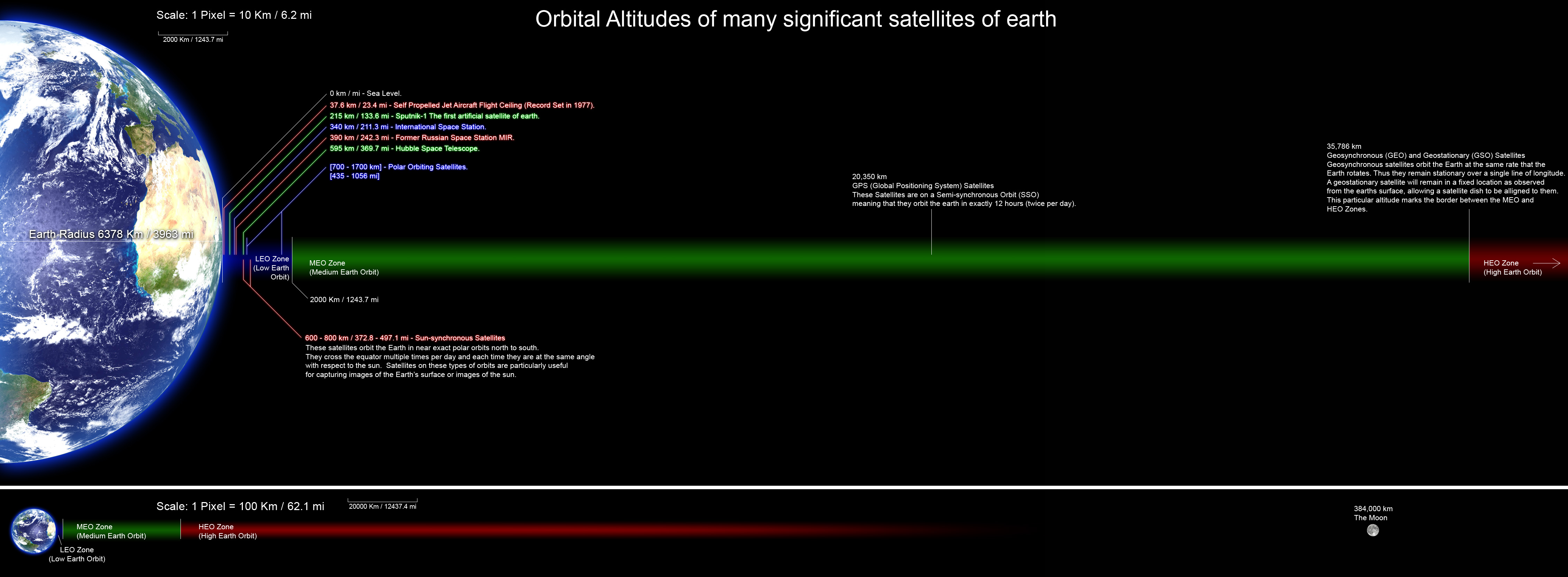
English: A perfectly scaled diagram showing the orbital altitudes of several significant satellites of earth. all planets and orbital distances are drawn to scale and the altitude data was collected from many Wikipedia articles and various other sites. |
| நாள் | |
| மூலம் | சொந்த முயற்சி |
| ஆசிரியர் | Rrakanishu |
Template loop detected: Template:Autotranslate <includeonly></includeonly>
அனுமதி
இந்த ஆக்கத்தின் காப்புரிமையாளரான நான் இதனைப் பின்வரும் உரிமத்தின் கீழ் வெளியிடுகின்றேன்:

|
GNU Free Documentation License விதிமுறைகளின் கீழ் இந்த ஆவணத்தை நகலெடுக்க, விநியோகிக்க மற்றும்/அல்லது மாற்றுவதற்கு அனுமதி வழங்கப்பட்டுள்ளது, Free Software Foundation;ஆல் வெளியிடப்பட்ட பதிப்பு 1.2 அல்லது அதற்குப் பிந்தைய பதிப்பு, மாற்றமில்லாத பிரிவுகள், முன் அட்டை உரைகள் மற்றும் பின் அட்டை உரைகள் இல்லாமல் வெளியிடப்பட்டது. GNU Free Documentation License என்ற தலைப்பில் உரிமத்தின் நகல் சேர்க்கப்பட்டுள்ளது. |
This file is licensed under the Creative Commons Attribution-Share Alike 4.0 International, 3.0 Unported, 2.5 Generic, 2.0 Generic and 1.0 Generic license.
- நீங்கள் சுதந்திரமாக:
- பகிர்ந்து கொள்ள – வேலையை நகலெடுக்க, விநியோகிக்க மற்றும் அனுப்ப
- மீண்டும் கலக்க – வேலைக்கு பழகிக்கொள்ள.
- கீழ்க்காணும் விதிகளுக்கு ஏற்ப,
- பண்புக்கூறுகள் – நீங்கள் பொருத்தமான உரிமையை வழங்க வேண்டும், உரிமத்திற்கான இணைப்பை வழங்க வேண்டும் மற்றும் மாற்றங்கள் செய்யப்பட்டிருந்தால் குறிப்பிட வேண்டும். நீங்கள் ஏற்புடைய எந்த முறையிலும் அவ்வாறு செய்யலாம், ஆனால் எந்த வகையிலும் உரிமதாரர் உங்களை அல்லது உங்கள் பயன்பாட்டிற்கு ஒப்புதல் அளிக்கும் படி பரிந்துரைக்க கூடாது.
- அதே மாதிரி பகிர் – நீங்கள் ரீமிக்ஸ் செய்தாலோ, உருமாற்றம் செய்தாலோ அல்லது பொருளை உருவாக்கினாலோ, உங்கள் பங்களிப்புகளை அல்லது இணக்கமான உரிமம் கீழ் அசலாக விநியோகிக்க வேண்டும்.
நீர் உமக்கு விருப்பமான உரிமத்தை தேர்ந்தெடுக்கலாம்.
கோப்பின் வரலாறு
குறித்த நேரத்தில் இருந்த படிமத்தைப் பார்க்க அந்நேரத்தின் மீது சொடுக்கவும்.
| நாள்/நேரம் | நகம் அளவு சிறுபடம் | அளவுகள் | பயனர் | கருத்து | |
|---|---|---|---|---|---|
| தற்போதைய | 12:13, 25 ஆகத்து 2011 | 4,500 × 1,656 (884 KB) | Rrakanishu | Corrected Typo's | |
| 18:15, 24 ஆகத்து 2011 | 4,500 × 1,656 (884 KB) | Rrakanishu | Added a visual scale to both sections Color coded the items in LEO zone so that its easier to follow the lines. Added some more information. | ||
| 08:38, 12 ஆகத்து 2010 | 4,500 × 1,656 (1.02 MB) | IdLoveOne~commonswiki | better contrast on Earth 3 | ||
| 06:46, 12 ஆகத்து 2010 | 4,500 × 1,656 (1.02 MB) | IdLoveOne~commonswiki | Added conversions and fixed "longitude" | ||
| 19:25, 9 சூன் 2008 | 4,500 × 1,656 (530 KB) | Rrakanishu | {{Information |Description={{en|1=Perfect scaled diagram showing the orbital altitudes of several significant satellites of earth. all planets and orbital distances are drawn to scale and the altitude data was collected from many wikipedia articles and va | ||
| 19:17, 9 சூன் 2008 | 4,500 × 1,656 (507 KB) | Rrakanishu | {{Information |Description={{en|1=Perfect scaled diagram showing the orbital altitudes of several significant satellites of earth. all planets and orbital distances are drawn to scale and the altitude data was collected from many wikipedia articles and v |
கோப்பு பயன்பாடு
பின்வரும் 2 பக்கங்கள் இணைப்பு இப் படிமத்துக்கு இணைக்கபட்டுள்ளது(ளன):
கோப்பின் முழுமையான பயன்பாடு
கீழ்கண்ட மற்ற விக்கிகள் இந்த கோப்பை பயன்படுத்துகின்றன:
- ar.wikipedia.org-திட்டத்தில் இதன் பயன்பாடு
- bn.wikipedia.org-திட்டத்தில் இதன் பயன்பாடு
- ca.wikipedia.org-திட்டத்தில் இதன் பயன்பாடு
- en.wikipedia.org-திட்டத்தில் இதன் பயன்பாடு
- Medium Earth orbit
- Wikipedia:Valued picture candidates/File:Orbitalaltitudes.jpg
- Wikipedia:Valued picture candidates/August-2010
- Human presence in space
- User talk:IdLoveOne/Archive 1
- Wikipedia:Featured picture candidates/Orbital Altitudes
- Wikipedia:Featured picture candidates/September-2011
- Talk:Satellite/Archive 1
- Space Development Agency
- es.wikipedia.org-திட்டத்தில் இதன் பயன்பாடு
- et.wikipedia.org-திட்டத்தில் இதன் பயன்பாடு
- fa.wikipedia.org-திட்டத்தில் இதன் பயன்பாடு
- gu.wikipedia.org-திட்டத்தில் இதன் பயன்பாடு
- he.wikipedia.org-திட்டத்தில் இதன் பயன்பாடு
- hi.wikipedia.org-திட்டத்தில் இதன் பயன்பாடு
- hy.wikipedia.org-திட்டத்தில் இதன் பயன்பாடு
- id.wikipedia.org-திட்டத்தில் இதன் பயன்பாடு
- it.wikipedia.org-திட்டத்தில் இதன் பயன்பாடு
- ja.wikipedia.org-திட்டத்தில் இதன் பயன்பாடு
- kk.wikipedia.org-திட்டத்தில் இதன் பயன்பாடு
- lt.wikipedia.org-திட்டத்தில் இதன் பயன்பாடு
- mk.wikipedia.org-திட்டத்தில் இதன் பயன்பாடு
- ml.wikipedia.org-திட்டத்தில் இதன் பயன்பாடு
- ms.wikipedia.org-திட்டத்தில் இதன் பயன்பாடு
- ne.wikipedia.org-திட்டத்தில் இதன் பயன்பாடு
- pt.wikipedia.org-திட்டத்தில் இதன் பயன்பாடு
- ro.wikibooks.org-திட்டத்தில் இதன் பயன்பாடு
- ru.wikipedia.org-திட்டத்தில் இதன் பயன்பாடு
- sh.wikipedia.org-திட்டத்தில் இதன் பயன்பாடு
- sl.wikipedia.org-திட்டத்தில் இதன் பயன்பாடு
- sr.wikipedia.org-திட்டத்தில் இதன் பயன்பாடு
- te.wikipedia.org-திட்டத்தில் இதன் பயன்பாடு
சிறப்பு பக்கம்-மொத்த பயன்பாடு - இதன் மூலம் இந்த கோப்பின் மொத்த பயன்பாட்டை அறிய முடியும்