படிமம்:Road network CPEC.jpg
இந்த முன்னோட்டத்தின் அளவு: 799 × 600 படப்புள்ளிகள் . மற்ற பிரிதிறன்கள்: 320 × 240 படப்புள்ளிகள் | 640 × 480 படப்புள்ளிகள் | 962 × 722 படப்புள்ளிகள் .
மூலக்கோப்பு (962 × 722 படவணுக்கள், கோப்பின் அளவு: 137 KB, MIME வகை: image/jpeg)
| இது விக்கிமீடியா பொதுக்கோப்பகத்தில் இருக்கும் ஒரு கோப்பாகும். இக்கோப்பைக் குறித்து அங்கே காணப்படும் படிம விளக்கப் பக்கத்தை இங்கே கீழே காணலாம்.
|
சுருக்கம்
| விளக்கம் |
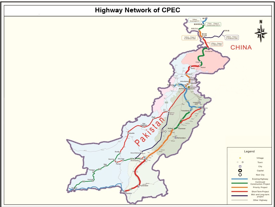
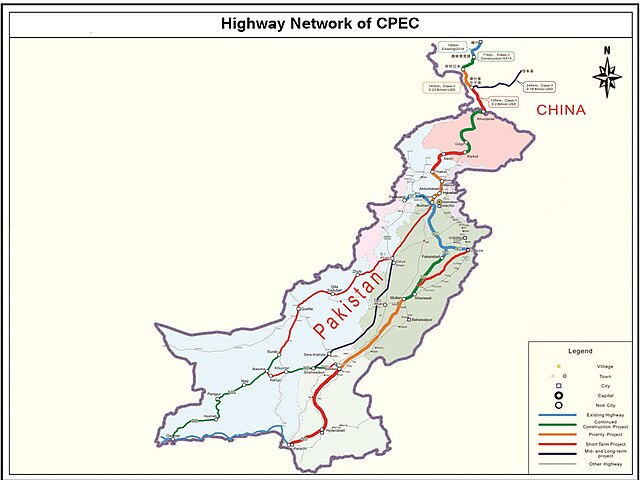
English: It describes Eastern Western and Central alignment of CPEC |
| நாள் | |
| மூலம் | http://www.pc.gov.pk/wp-content/uploads/2016/01/Highway-Network-of-cpac-new.jpg |
| ஆசிரியர் | Government of Pakistan |
This file is in the public domain because Planning commision of Pakistan
|
கோப்பின் வரலாறு
குறித்த நேரத்தில் இருந்த படிமத்தைப் பார்க்க அந்நேரத்தின் மீது சொடுக்கவும்.
| நாள்/நேரம் | நகம் அளவு சிறுபடம் | அளவுகள் | பயனர் | கருத்து | |
|---|---|---|---|---|---|
| தற்போதைய | 00:19, 28 செப்டெம்பர் 2023 | | 962 × 722 (137 KB) | Eggrollll | Reverted to version as of 17:10, 4 December 2020 (UTC) |
| 17:11, 4 திசம்பர் 2020 |  | 962 × 722 (125 KB) | Pathfinder454 | Map published by user Badri2017 is forged / edited without copyrights obtained from Government of Pakistan. Original file published by user Baltistani478 is the actual map depicting road networks of CPEC as published at official website http://cpec.gov.pk/map-single/1 Therefore File Reverted to version as of 16:49, 23 May 2016 (UTC) | |
| 17:10, 4 திசம்பர் 2020 |  | 962 × 722 (137 KB) | Pathfinder454 | Reverted to version as of 10:15, 19 July 2017 (UTC) Map published by user Badri2017 is forged / edited without copyrights obtained from Government of Pakistan. Original file published by user Baltistani478 is the actual map depicting road networks of CPEC as published at official website http://cpec.gov.pk/map-single/1 Therefore File Reverted to version as of 16:49, 23 May 2016 (UTC | |
| 17:01, 4 திசம்பர் 2020 |  | 962 × 722 (125 KB) | Pathfinder454 | Map published by user Badri2017 is forged / edited without copyrights obtained from Government of Pakistan. Original file published by user Baltistani478 is the actual map depicting road networks of CPEC as published at official website http://cpec.gov.pk/map-single/1 Therefore File Reverted to version as of 16:49, 23 May 2016 (UTC) | |
| 10:15, 19 சூலை 2017 |  | 962 × 722 (137 KB) | Badri2017 | Neutral Map, Indian administered Kashmir is neither part of CPEC nor Pak territory | |
| 16:49, 23 மே 2016 |  | 962 × 722 (125 KB) | Baltistani478 | {{subst:Upload marker added by en.wp UW}} {{Information |Description = {{en|It describes Eastern Western and Central alignment of CPEC}} |Source = http://www.pc.gov.pk/wp-content/uploads/2016/01/Highway-Network-of-cpac-new.jpg |Date = January 2016 |Aut... |
கோப்பு பயன்பாடு
பின்வரும் பக்க இணைப்புகள் இப் படிமத்துக்கு இணைக்கபட்டுள்ளது(ளன):
கோப்பின் முழுமையான பயன்பாடு
கீழ்கண்ட மற்ற விக்கிகள் இந்த கோப்பை பயன்படுத்துகின்றன:
- ar.wikipedia.org-திட்டத்தில் இதன் பயன்பாடு
- bn.wikipedia.org-திட்டத்தில் இதன் பயன்பாடு
- ca.wikipedia.org-திட்டத்தில் இதன் பயன்பாடு
- en.wikipedia.org-திட்டத்தில் இதன் பயன்பாடு
- eo.wikinews.org-திட்டத்தில் இதன் பயன்பாடு
- hi.wikipedia.org-திட்டத்தில் இதன் பயன்பாடு
- mr.wikipedia.org-திட்டத்தில் இதன் பயன்பாடு
- pa.wikipedia.org-திட்டத்தில் இதன் பயன்பாடு
- pnb.wikipedia.org-திட்டத்தில் இதன் பயன்பாடு
- sat.wikipedia.org-திட்டத்தில் இதன் பயன்பாடு
- sd.wikipedia.org-திட்டத்தில் இதன் பயன்பாடு
- zh.wikipedia.org-திட்டத்தில் இதன் பயன்பாடு