மேகதூது நடவடிக்கை
(மேகதூது நடிவடிக்கை இலிருந்து வழிமாற்றப்பட்டது)
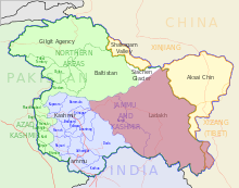
மேகதூது நடவடிக்கை (Operation Meghdoot), பாகிஸ்தான் ஆக்கிரமிப்பில் இருந்த சியாச்சின் கொடுமுடியைக் கைப்பற்ற, 13 ஏப்ரல் 1984 அன்று இந்திய இராணுவத்தால் எடுக்கப்பட்ட இராணுவ நடவடிக்கை ஆகும்.[8][9] இந்நடவடிக்கை சியாச்சின் பிணக்கின் ஒரு பகுதியாகும். இந்நடவடிக்கையால் காரகோரம் மலைத்தொடரில் 6,400 மீட்டர்கள் (21,000 அடி) உயரத்தில் உள்ள சியாச்சின் கொடுமுடி கைப்பற்றப்பட்டு இந்தியாவின் லடாக் பிரதேசத்துடன் இணைக்கப்பட்டது.
| மேகதூது நடவடிக்கை | |||||||||
|---|---|---|---|---|---|---|---|---|---|
 ஜம்மு காஷ்மீரில் வெள்ளை நிறத்தில் சியாச்சின்னின் அமைவிடம் |
|||||||||
|
|||||||||
| பிரிவினர் | |||||||||
| தளபதிகள், தலைவர்கள் | |||||||||
| லெப்டினண்ட் ஜெனரல் பிரேம் நாத் ஹூன் மேஜர் ஆர். எஸ். சாந்து கேப்டன் சஞ்சய் குல்கர்னி கேப்டன் பி. வி. யாதவ் | லெப்டினண்ட் ஜெனரல் சாகீத் அலி அக்பர் கான் பிரிகேடியர் ஜெனரல் பெர்வேஸ் முஷாரஃப் |
||||||||
| பலம் | |||||||||
| 3,000+[5] | 3,000 | ||||||||
| இழப்புகள் | |||||||||
| தெரியவில்லை | தெரியவில்லை[6][7] | ||||||||
இதனையும் காண்க
தொகுமேற்கோள்கள்
தொகு- ↑ See http://www.bharat-rakshak.com/ARMY/history/siachen/290-confrontation.html பரணிடப்பட்டது 2016-09-17 at the வந்தவழி இயந்திரம் for a detailed description of Indian forces taking control of Bilafond La in 1987. and pages 19-20 plus the map on p. 21 at http://www.sandia.gov/cooperative-monitoring-center/_assets/documents/sand20075670.pdf , Pakistani control over the heights just to the west, near "Naveed Top" east of Chumik Glacier, contrary to the oft-copied misstatement in the old error-plagued summary at http://www.globalsecurity.org/military/world/war/siachen.htm
- ↑ Noorani, A.G. (10 March 2006). "For the first time, the leaders of India and Pakistan seem close to finding a solution to the Kashmir problem.". for a detailed, current map. http://www.frontlineonnet.com/fl2304/stories/20060310001704400.htm.
- ↑ "Indians have been able to hold on to the tactical advantage of the high ground. Most of India's many outposts are west of the (Siachen) Glacier along the Saltoro Range. Bearak, Barry (23 May 1999). "THE COLDEST WAR; Frozen in Fury on the Roof of the World". The New York Times. https://query.nytimes.com/gst/fullpage.html?res=9807EFDA1431F930A15756C0A96F958260&sec=&spon=&&scp=1&sq=%22May%2023,%201999%22%20%22Roof%20of%20the%20World%22&st=cse.
- ↑ In an academic study with detailed maps and satellite images, co-authored by brigadiers from both the Pakistani and Indian military, pages 16 and 27: "Since 1984, the Indian army has been in physical possession of most of the heights on the Saltoro Range west of the Siachen Glacier, while the Pakistan army has held posts at lower elevations of western slopes of the spurs emanating from the Saltoro ridgeline. The Indian army has secured its position on the ridgeline." Hakeem, Asad; Gurmeet Kanwal; Michael Vannoni; Gaurav Rajen (1 செப்டெம்பர் 2007). "Demilitarization of the Siachen Conflict Zone" (PDF). Sandia Report. Sandia National Laboratories, Albuquerque, NM, USA. Archived from the original (PDF) on 17 ஏப்பிரல் 2012. பார்க்கப்பட்ட நாள் 20 பெப்பிரவரி 2009.
- ↑ "War at the Top of the World". Time.com. 7 November 2005 இம் மூலத்தில் இருந்து 12 ஏப்ரல் 2012 அன்று. பரணிடப்பட்டது.. https://web.archive.org/web/20120412045808/http://www.time.com/time/magazine/article/0,9171,1079528-1,00.html.
- ↑ Kumar Pandey, Hemant; Raj Singh, Manish (1 August 2017). INDIA'S MAJOR MILITARY & RESCUE OPERATIONS. Horizon Books. p. 141. பன்னாட்டுத் தரப்புத்தக எண் 9789386369390.
Camps were soon converted into permanent post by both countries. The number of casualties on both sides during this operation is not known.
- ↑ "HIGH TIME TO SETTLE SIACHEN". The Citizen India. 28 பெப்பிரவரி 2016. Archived from the original on 21 ஆகத்து 2019.
- ↑ Operation Meghdoot
- ↑ Operation Meghdoot