வார்ப்புரு:Infobox earthquake
Usage
தொகு{{Infobox earthquake
| name =
| image = <!-- file name only -->
| alt =
| caption =
| map = <!-- file name only -->
| map_alt =
| map_caption =
| map2 = <!-- manual map or use {{Location map}} -->
| date = <!-- {{Start date|YYYY|MM|DD}} -->
| time =
| duration =
| magnitude = <!-- N.N ([[உந்தத்திறன் ஒப்பளவு|M<sub>w</sub>]]) -->
| depth = <!-- {{convert|NNN|km|mi|0|abbr=on}} -->
| location = <!-- {{coord|XXXXX|region:XX_type:event|display=inline,title}} -->
| fault =
| type =
| affected =
| damages = <!-- cost/extent of property damage -->
| intensity =
| pga = <!-- NN''[[Peak ground acceleration|g]]'' -->
| tsunami =
| landslide =
| foreshocks =
| aftershocks =
| casualties =
| engvar = <!-- follow article: =en-UK will show 'Epicentre' -->
}}
Examples
தொகு Piles of rubble, one week after the shock | |
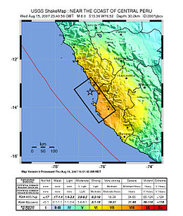
 Map of the Peru coastline, showing location and strength of quake. Star marks நிலநடுக்க மையம். | |
| நாள் | ஆகத்து 15, 2007 |
|---|---|
| தொடக்க நேரம் | 23:40:57 ஒருங்கிணைந்த அனைத்துலக நேரம் |
| நிலநடுக்க அளவு | 8.0 (Mw) |
| ஆழம் | 39 km (24 mi) |
| நிலநடுக்க மையம் | 13°21′14″S 76°30′32″W / 13.354°S 76.509°W |
| உரசுமுனை | Nazca-South American plate |
| பாதிக்கப்பட்ட பகுதிகள் | Ica Region (Pisco, Ica and Chincha Alta) and Lima Region (San Vicente de Cañete) |
| ஆழிப்பேரலை | flooded part of Lima's Costa Verde highway, and much of Pisco's shore |
| உயிரிழப்புகள் | 519 confirmed dead, 1,366 injured |
{{Infobox earthquake
 | name        = 2007 Peru earthquake
 | image       = 40 - Tremblement de terre - Août 2007.JPG
 | alt         = Picture showing earthquake damage.
 | caption     = Piles of rubble, one week after the shock
 | map         = Peru Quake Aug 15-2007.jpg
 | map_alt     = Map of the Peru coastline, showing location and strength of quake.
 | map_caption = Map of the Peru coastline, showing location and strength of quake. Star marks [[நிலநடுக்க மையம்]].
 | date        = {{Start date|2007|8|15}}
 | time        = 23:40:57 [[ஒருங்கிணைந்த அனைத்துலக நேரம்]]
 | magnitude   = 8.0 ([[உந்தத்திறன் ஒப்பளவு|M<sub>w</sub>]])
 | depth       = {{convert|39|km|mi|abbr=on}}
 | location    = {{coord|13.354|S|76.509|W|region:PE_type:event|display=inline,title}}
 | fault       = [[Nazca Plate|Nazca]]-[[South American Plate|South American plate]]
 | affected    = [[Ica Region]] ([[Pisco, Peru|Pisco]], [[Ica (city)|Ica]] and [[Chincha Alta]]) and [[Lima Region]] ([[San Vicente de Cañete]])
 | tsunami     = flooded part of Lima's Costa Verde highway, and much of Pisco's shore
 | casualties  = 519 confirmed dead, 1,366 injured
}}