படிமம்:PIA17470 Titan northern hemisphere.jpg
மூலக்கோப்பு (2,120 × 1,600 படவணுக்கள், கோப்பின் அளவு: 1.02 MB, MIME வகை: image/jpeg)
| இது விக்கிமீடியா பொதுக்கோப்பகத்தில் இருக்கும் ஒரு கோப்பாகும். இக்கோப்பைக் குறித்து அங்கே காணப்படும் படிம விளக்கப் பக்கத்தை இங்கே கீழே காணலாம்.
|
சுருக்கம்
| விளக்கம் |
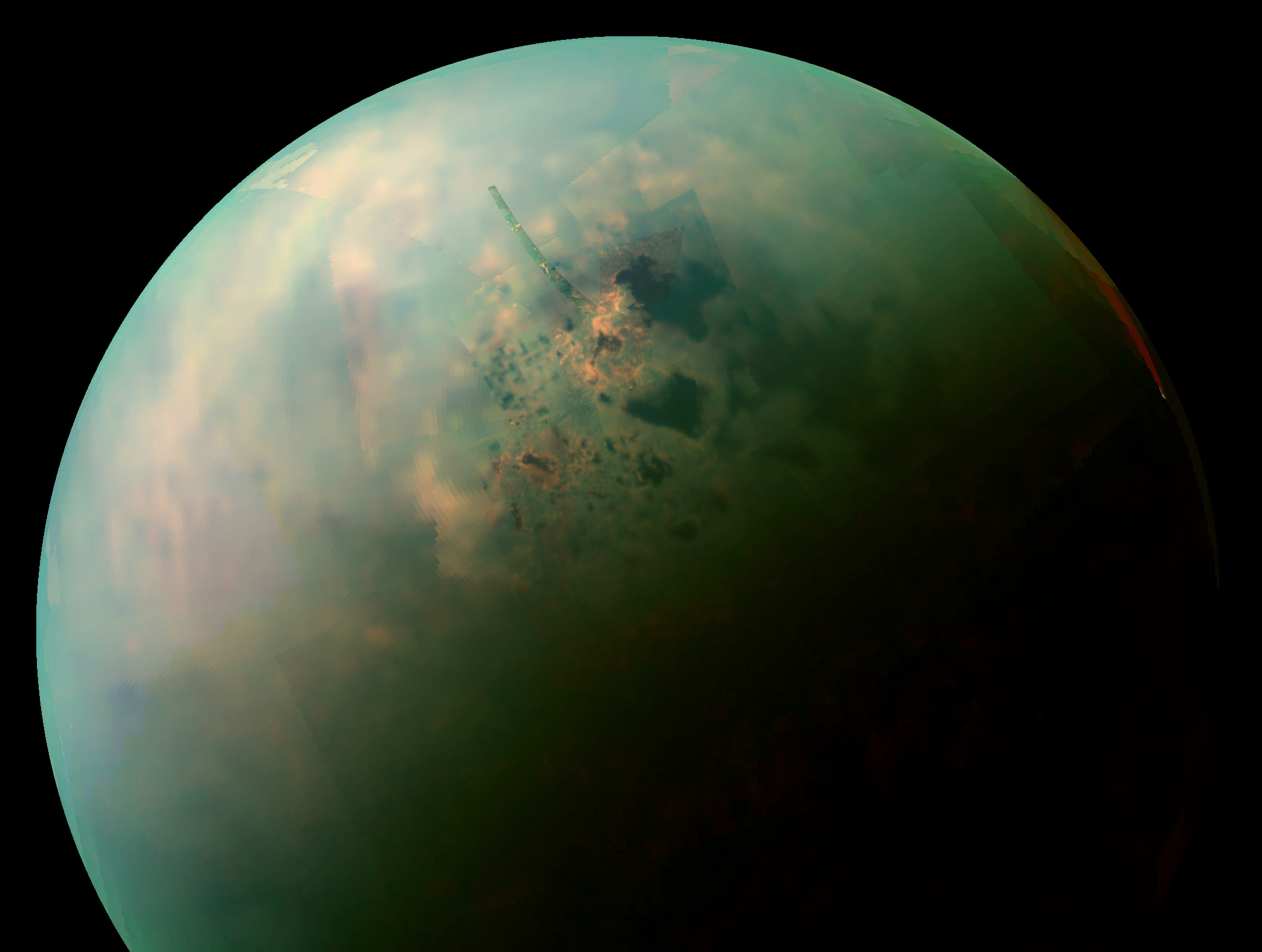
English: This false-color mosaic, made from infrared data collected by NASA's Cassini spacecraft, reveals the differences in the composition of surface materials around hydrocarbon lakes at Titan, Saturn's largest moon. Titan is the only other place in the solar system that we know has stable liquid on its surface, though its lakes are made of liquid ethane and methane rather than liquid water. While there is one large lake and a few smaller ones near Titan's south pole, almost all of Titan's lakes appear near the moon's north pole.
Scientists mapped near-infrared colors onto the visible color spectrum. Red in this image was assigned a wavelength of 5 microns (10 times longer than visible light), green 2.0 microns (four times longer than visible light), and blue 1.3 microns (2.6 times longer than visible light). The orange areas are thought to be evaporite -- the Titan equivalent of salt flats on Earth. The evaporated material is thought to be organic chemicals originally from Titan's haze particles that once dissolved in liquid methane. They appear orange in this image against the greenish backdrop of Titan's typical bedrock of water ice. In this mosaic, Kraken Mare, which is Titan's largest sea and covers about the same area as Earth's Caspian Sea and Lake Superior combined, can be seen spreading out with many tendrils on the upper right,. The big dark zone up and left of Kraken is Ligeia Mare, the second largest sea. Below Ligeia, shaped similar to a sports fan's foam finger that points just up from left, is Punga Mare, the third Titan Sea. Numerous other smaller lakes dot the area. Titan's north pole is located in the geographic location just above the end of the "finger" of Punga Mare. An annotated version of this image, with a high-resolution strip highlighted, is also available. In this version, the north pole is marked with a red cross and other smaller lakes are also labeled. The data shown here were obtained by Cassini's visual and infrared mapping spectrometer during a close flyby of Titan on Sept. 12, 2013. Until now, the spectrometer has only been able to capture distant, oblique or partial views of this area until now. The Sept. 12, 2013 flyby provided better viewing geometry. And sunlight has begun to pierce the winter darkness that shrouded Titan's north pole at Cassini's arrival in the Saturn system nine years ago. A thick cap of haze that once hung over the north pole has also dissipated as northern summer approaches. And, thankfully, Titan's beautiful, almost cloudless, rain-free weather continued during this flyby. The resolution varies across this composite view depending on when each cube of data was acquired, but the best surface sampling is 2 miles (3 kilometers) per pixel. Views of this area by other Cassini instruments include PIA17471, PIA17472, PIA17473 and PIA14584 from the imaging science subsystem; and PIA10008 and PIA17031 from the radar mapper. An earlier VIMS view can be seen at PIA16845. The Cassini-Huygens mission is a cooperative project of NASA, the European Space Agency and the Italian Space Agency. The Jet Propulsion Laboratory, a division of the California Institute of Technology in Pasadena, manages the Cassini-Huygens mission for NASA\'s Science Mission Directorate, Washington, D.C. The imaging team consists of scientists from the US, England, France, and Germany. The visual and infrared mapping spectrometer team is based at the University of Arizona. The imaging operations center and team lead (Dr. C. Porco) are based at the Space Science Institute in Boulder, Colo. For more information about the Cassini-Huygens mission, visit http://saturn.jpl.nasa.gov and the Cassini imaging team home page, http://ciclops.org. The original NASA image has been cropped, and borders were added. Some of the features in this image have been annotated in Wikimedia Commons. |
| நாள் | |
| மூலம் | http://www.ciclops.org/view/7733/Titans-Northern-Lakes-Salt-Flats |
| ஆசிரியர் | NASA / JPL-Caltech / Space Science Institute |
அனுமதி
| This file is in the public domain in the United States because it was solely created by NASA. NASA copyright policy states that "NASA material is not protected by copyright unless noted". (See Template:PD-USGov, NASA copyright policy page or JPL Image Use Policy.) | ||
 |
Warnings:
|
| Annotations | This image is annotated: View the annotations at Commons |
கோப்பின் வரலாறு
குறித்த நேரத்தில் இருந்த படிமத்தைப் பார்க்க அந்நேரத்தின் மீது சொடுக்கவும்.
| நாள்/நேரம் | நகம் அளவு சிறுபடம் | அளவுகள் | பயனர் | கருத்து | |
|---|---|---|---|---|---|
| தற்போதைய | 04:31, 26 அக்டோபர் 2013 | | 2,120 × 1,600 (1.02 MB) | WolfmanSF | User created page with UploadWizard |
கோப்பு பயன்பாடு
பின்வரும் 3 பக்கங்கள் இணைப்பு இப் படிமத்துக்கு இணைக்கபட்டுள்ளது(ளன):
கோப்பின் முழுமையான பயன்பாடு
கீழ்கண்ட மற்ற விக்கிகள் இந்த கோப்பை பயன்படுத்துகின்றன:
- ar.wikipedia.org-திட்டத்தில் இதன் பயன்பாடு
- bn.wikipedia.org-திட்டத்தில் இதன் பயன்பாடு
- en.wikipedia.org-திட்டத்தில் இதன் பயன்பாடு
- fa.wikipedia.org-திட்டத்தில் இதன் பயன்பாடு
- id.wikipedia.org-திட்டத்தில் இதன் பயன்பாடு
- it.wikipedia.org-திட்டத்தில் இதன் பயன்பாடு
- pl.wikipedia.org-திட்டத்தில் இதன் பயன்பாடு
- zh.wikipedia.org-திட்டத்தில் இதன் பயன்பாடு