கில்பர்ட்டு தீவுக்கூட்டம்
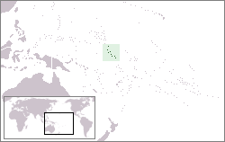
கில்பர்ட்டு தீவுக்கூட்டம் (Gilbert Islands[2] முந்தையப் பெயர்: Kingsmill அல்லது King's-Mill Islands[3]) என்பன வரிசையாக உள்ள பதினாறு பவளத் தீவுகள் ஆகும். இவை அமைதிப் பெருங்கடல் பரப்பில் பப்புவா நியூ கினிக்கும், ஹவாய் தீவுக்கும் இடையேயான சரிபாதி தூரத்தில் அமைந்துள்ளது. கிரிபட்டி நாட்டின் முக்கிய நிலப்பகுதியாகும். தீவுப்பெயரான "Gilberts" என்பது உள்ளூர் (Gilbertese language) மொழியைக் குறிக்கிறது. .[2] இத்தீவுக்கூட்டமானது, வடகில்பர்டு தீவுகள், தென்கில்பர்டு தீவுகள் என இரண்டு பெருங்கூட்டமாகப் பிரிக்கப்பட்டுள்ளது. இந்த இரு பிரிவுகளுக்கும் இடையில் நிலநடுக் கோடு உள்ளது. பன்னாட்டு நீரியியல் கழகம் (International Hydrographic Organization. (IHO)) ஒட்டு மொத்த கில்பர்டு தீவுக்கூட்டமும், அமைதிப் பெருங்கடல் தெற்குப் பகுதியாகவே குறிப்பிடுகிறது.[4] வடகில்பர்டு தீவுகளில் நிருவாக அமைப்புகள் அதிகமுள்ளன.[5] வடக்கு, தெற்கு தீவுக்கூட்டங்களுக்கு இடையில் இருக்கும் நடுப்பகுதி கலாச்சார முக்கியத்துவமுள்ள பகுதிகள் அதிகம் உள்ளன.[6] இத்தீவுகளில் 84% பேர் படித்தவர்கள். ரோமன் கத்தோலிக்க கிறித்தவர்கள் 35% உள்ளனர்.
Colony of Gilbert Islands | |||||||||
|---|---|---|---|---|---|---|---|---|---|
| 1976–1979 | |||||||||
| நாட்டுப்பண்: "God Save the Queen" | |||||||||
 | |||||||||
| தலைநகரம் | South Tarawa | ||||||||
| பேசப்படும் மொழிகள் | ஆங்கிலம், Gilbertese | ||||||||
| அரசாங்கம் | Colony of the ஐக்கிய இராச்சியம் | ||||||||
| Monarch | |||||||||
• 1976–1979 | ஐக்கிய இராச்சியத்தின் இரண்டாம் எலிசபெத் | ||||||||
| Governor of the Gilbert and Ellice Islands | |||||||||
• 1976–1978 | John Hilary Smith | ||||||||
• 1978–1979 | Reginald James Wallace | ||||||||
| வரலாறு | |||||||||
• Colony | 1 January[1] 1976 | ||||||||
• முடிவு | 12 சூலை 1979 | ||||||||
| மக்கள் தொகை | |||||||||
• 1978 | 56,213 | ||||||||
| நாணயம் | அவுஸ்திரேலிய டொலர் | ||||||||
| |||||||||
| தற்போதைய பகுதிகள் | கிரிபட்டி | ||||||||
மேற்கோள்கள்
தொகு- ↑ W. David McIntyre. "The Partition of the Gilbert and Ellice Islands" (PDF). Island Studies Journal, Vol. 7, No. 1, 2012. pp. 135–146. Archived from the original (PDF) on 2 December 2017. பார்க்கப்பட்ட நாள் 18 மார்ச்சு 2024.
- ↑ 2.0 2.1 Reilly Ridgell. Pacific Nations and Territories: The Islands of Micronesia, Melanesia, and Polynesia. 3rd. Ed. Honolulu: Bess Press, 1995. p. 95.
- ↑ Very often, this name applied only to the southern islands of the archipelago, the northern half being designated as the Scarborough Islands. Merriam-Webster's Geographical Dictionary. Springfield, Massachusetts: Merriam Webster, 1997. p. 594
- ↑ "Limits of Oceans and Seas, 3rd edition" (PDF). International Hydrographic Organization. 1953. பார்க்கப்பட்ட நாள் 28 December 2020.
- ↑ Stevenson, Robert Louis (1987) [1896]. In the South Seas, Part V, Chapter 1. Chatto & Windus; republished by The Hogarth Press.
- ↑ Grimble, Arthur (1981). A Pattern of Islands. Penguin Travel Library. Penguin Books. பன்னாட்டுத் தரப்புத்தக எண் 978-0-14-009517-3.
வெளியிணைப்புகள்
தொகு- பொதுவகத்தில் Gilbert Islands தொடர்பாக ஊடகக் கோப்புகள் உள்ளன.
- The Battle for Tarawa, Appendix G
- "Gilbert Islands". பிரித்தானிக்கா கலைக்களஞ்சியம் (11th). (1911).

